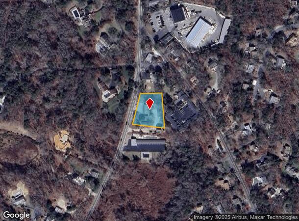
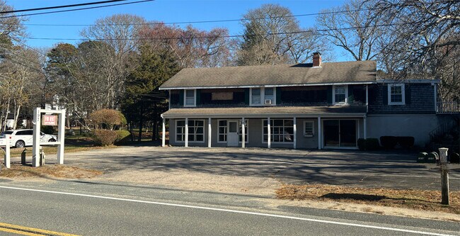
Property Record
197 Main St, Dennis, MA 02638

NEARBY LISTINGS FOR SALE OR LEASE
-
-
View all Dennis listings for lease on LoopNet.com
Property Detail
197 Main St
DENN-000072-000000-000001
Barnstable
Commercialofficeresidentialmixeduse
Massachusetts
X
0.70 AC
25001C0577J
Cape Cod
2025
Other Market Areas
2025
Barnstable Town, MA
011300
DEMOGRAPHICS near 197 Main St
1 mile
3 mile
5 mile
2024 Total Population
3,012
17,582
36,479
2029 Population
3,108
17,965
37,482
Pop Growth 2024-2029
+ 3.19%
+ 2.18%
+ 2.75%
Average Age
58
54
52
2024 Total Households
1,530
8,293
16,968
HH Growth 2024-2029
+ 2.81%
+ 1.77%
+ 2.48%
Median Household Inc
$103,571
$90,654
$83,986
Avg Household Size
1.90
2.00
2.10
2024 Avg HH Vehicles
2.00
2.00
2.00
Median Home Value
$491,702
$470,285
$464,578
Median Year Built
1979
1976
1974
Nearby Places
Map Layers
Map Styles
 Street
 Aerial
Transit
 Traffic
 Biking
Places
Listings with unknown addresses are not visible on the map
- Restaurants
- Banks
- Shops
- Fitness
- Groceries
PUBLIC TRANSPORTATION
COMMUTER RAIL
Drive
Walk
Distance
13 min
7.1 mi
AIRPORT
Nantucket Memorial
Drive
Walk
Distance
Nantucket Memorial
163 min
40.9 mi
Martha's Vineyard
Drive
Walk
Distance
Martha's Vineyard
116 min
45.4 mi
Freight Ports
Port of New Bedford Harbor
Drive
Walk
Distance
Port of New Bedford Harbor
76 min
53.8 mi
SALE & LEASE HISTORY
LISTING DATE
SALE/LEASE

Dec 02, 2024
For Lease
Nearby Properties
Address
Land Use
TOTAL SIZE
Lot Size
Zoning
Address
Land Use
TOTAL SIZE
Lot Size
Zoning
11,698 SF
34.50 AC
Address
Land Use
TOTAL SIZE
Lot Size
Zoning
12.72 AC
R-60
Address
Land Use
TOTAL SIZE
Lot Size
Zoning
1,228 SF
10.54 AC
Address
Land Use
TOTAL SIZE
Lot Size
Zoning
222,477 SF
41.60 AC
Address
Land Use
TOTAL SIZE
Lot Size
Zoning
5,693 SF
5 AC
Address
Land Use
TOTAL SIZE
Lot Size
Zoning
34.40 AC
Address
Land Use
TOTAL SIZE
Lot Size
Zoning
5.11 AC
R-60
Address
Land Use
TOTAL SIZE
Lot Size
Zoning
2,560 SF
100.38 AC
Address
Land Use
TOTAL SIZE
Lot Size
Zoning
2.93 AC
R-60
Address
Land Use
TOTAL SIZE
Lot Size
Zoning
10,841 SF
1.69 AC
Address
Land Use
TOTAL SIZE
Lot Size
Zoning
6,784 SF
1.31 AC
Address
Land Use
TOTAL SIZE
Lot Size
Zoning
4,912 SF
6.70 AC
R-60
Address
Land Use
TOTAL SIZE
Lot Size
Zoning
320 SF
9.01 AC
Address
Land Use
TOTAL SIZE
Lot Size
Zoning
7,522 SF
1.93 AC
R-60
Address
Land Use
TOTAL SIZE
Lot Size
Zoning
5.42 AC
Address
Land Use
TOTAL SIZE
Lot Size
Zoning
5,689 SF
1.21 AC
Address
Land Use
TOTAL SIZE
Lot Size
Zoning
6,092 SF
0.97 AC
Address
Land Use
TOTAL SIZE
Lot Size
Zoning
2,955 SF
23.93 AC
R-60
Address
Land Use
TOTAL SIZE
Lot Size
Zoning
4,084 SF
6.96 AC
R-60
Address
Land Use
TOTAL SIZE
Lot Size
Zoning
163.08 AC
Address
Land Use
TOTAL SIZE
Lot Size
Zoning
38,518 SF
5.09 AC
Address
Land Use
TOTAL SIZE
Lot Size
Zoning
3,573 SF
2.38 AC
R-40
Address
Land Use
TOTAL SIZE
Lot Size
Zoning
5,194 SF
0.57 AC
Address
Land Use
TOTAL SIZE
Lot Size
Zoning
59,756 SF
9.56 AC
Address
Land Use
TOTAL SIZE
Lot Size
Zoning
18.49 AC
Address
Land Use
TOTAL SIZE
Lot Size
Zoning
5,010 SF
1.32 AC
Address
Land Use
TOTAL SIZE
Lot Size
Zoning
3,185 SF
6.53 AC
R-60
Address
Land Use
TOTAL SIZE
Lot Size
Zoning
6.12 AC
R-60
Address
Land Use
TOTAL SIZE
Lot Size
Zoning
44,504 SF
5.33 AC
Address
Land Use
TOTAL SIZE
Lot Size
Zoning
The World's #1 Commercial Real Estate Marketplace
Connect with us
© 2026 CoStar Group
The information above has been obtained from sources believed reliable. While we do not doubt its accuracy we have not verified it and make no guarantee, warranty or representation about it. It is your responsibility to independently confirm its accuracy and completeness. Any projections, opinions, assumptions, or estimates used are for example only and do not represent the current or future performance of the property. The value of this transaction to you depends on tax and other factors which should be evaluated by your tax, financial, and legal advisors. You and your advisors should conduct a careful, independent investigation of the property to determine to your satisfaction the suitability of the property for your needs.