Property Record
197 S Redmond Rd, Jacksonville, AR 72076
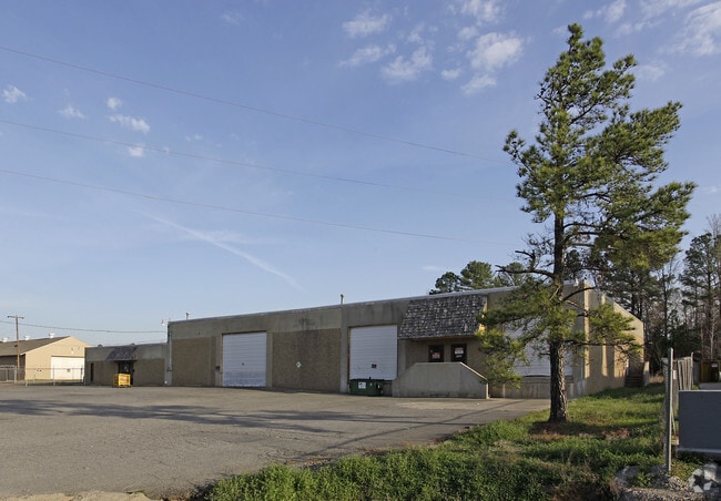

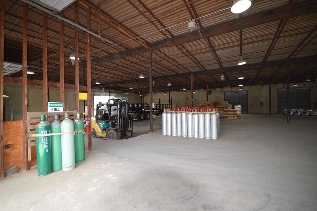
This Property Is For Sale
Current Lease Availabilities
NEARBY LISTINGS FOR SALE OR LEASE
Property Detail
197 S Redmond Rd
22J-018-00-034-00
PT E1/2 NE BEG NW COR NE NW N85*39E1385.58 S3*20W860.78 S48*09E446.50 TO POB N81*53E63.90 TO C CV TO L ON R/W MOP RR S35*E627.22 S55*40E305.53 TO INTERS R/W & NLY R/W REDMOND RD N74*08W ON R/W 831.92 N16*48E77 TO SLY R/W RD S80*27 E33.90
Officebuilding
Pulaski
AE
Arkansas
05119C0357H
1.87 AC
2025
Outlying Pulaski County
2025
Little Rock/N Little Rock
003605
Little Rock-North Little Rock-Conway, AR
1,350 SF
DEMOGRAPHICS near 197 S Redmond Rd
1 Mile
3 Mile
5 Mile
2024 Total Population
3,107
27,936
52,758
2029 Population
3,096
27,919
52,760
Pop Growth 2024-2029
(0.35%)
(0.06%)
0.00%
Average Age
37
37
38
2024 Total Households
1,284
11,001
21,092
HH Growth 2024-2029
(0.31%)
(0.11%)
(0.05%)
Median Household Inc
$44,230
$42,864
$50,386
Avg Household Size
2.30
2.40
2.40
2024 Avg HH Vehicles
2.00
2.00
2.00
Median Home Value
$141,575
$146,959
$166,093
Median Year Built
1982
1979
1983
Nearby Places
Map Layers
Map Styles
 Street
 Aerial
- Restaurants
- Banks
- Shops
- Fitness
- Groceries
PUBLIC TRANSPORTATION
AIRPORT
Bill and Hillary Clinton Ntl/Adams Field
DRIVE
WALK
Distance
Bill and Hillary Clinton Ntl/Adams Field
20 min
14.9 mi
Nearby Properties
Address
Land Use
TOTAL SIZE
Lot Size
Zoning
Address
Land Use
TOTAL SIZE
Lot Size
Zoning
78,183 SF
2.77 AC
Address
Land Use
TOTAL SIZE
Lot Size
Zoning
338,000 SF
22.81 AC
Address
Land Use
TOTAL SIZE
Lot Size
Zoning
116,987 SF
39.02 AC
Address
Land Use
TOTAL SIZE
Lot Size
Zoning
6,099.88 AC
Address
Land Use
TOTAL SIZE
Lot Size
Zoning
130,195 SF
10.11 AC
Address
Land Use
TOTAL SIZE
Lot Size
Zoning
92,654 SF
50.12 AC
Address
Land Use
TOTAL SIZE
Lot Size
Zoning
10 SF
10.14 AC
Address
Land Use
TOTAL SIZE
Lot Size
Zoning
5,850 SF
21.81 AC
Address
Land Use
TOTAL SIZE
Lot Size
Zoning
55,127 SF
11.26 AC
Address
Land Use
TOTAL SIZE
Lot Size
Zoning
76,936 SF
48.38 AC
Address
Land Use
TOTAL SIZE
Lot Size
Zoning
137,320 SF
14.27 AC
Address
Land Use
TOTAL SIZE
Lot Size
Zoning
60,232 SF
12.88 AC
Address
Land Use
TOTAL SIZE
Lot Size
Zoning
45,006 SF
6.33 AC
Address
Land Use
TOTAL SIZE
Lot Size
Zoning
37,333 SF
6.43 AC
Address
Land Use
TOTAL SIZE
Lot Size
Zoning
58,120 SF
8.58 AC
Address
Land Use
TOTAL SIZE
Lot Size
Zoning
71,861 SF
5.91 AC
Address
Land Use
TOTAL SIZE
Lot Size
Zoning
36,642 SF
3.99 AC
Address
Land Use
TOTAL SIZE
Lot Size
Zoning
86,675 SF
4.73 AC
Address
Land Use
TOTAL SIZE
Lot Size
Zoning
68,246 SF
10.71 AC
Address
Land Use
TOTAL SIZE
Lot Size
Zoning
19,514 SF
54.85 AC
Address
Land Use
TOTAL SIZE
Lot Size
Zoning
71,046 SF
9.18 AC
Address
Land Use
TOTAL SIZE
Lot Size
Zoning
33,668 SF
2.67 AC
Address
Land Use
TOTAL SIZE
Lot Size
Zoning
34,988 SF
9.14 AC
Address
Land Use
TOTAL SIZE
Lot Size
Zoning
6,576 SF
122.66 AC
Address
Land Use
TOTAL SIZE
Lot Size
Zoning
14,005 SF
5.45 AC
Address
Land Use
TOTAL SIZE
Lot Size
Zoning
1,426 SF
3.28 AC
Address
Land Use
TOTAL SIZE
Lot Size
Zoning
43,630 SF
12.38 AC
Address
Land Use
TOTAL SIZE
Lot Size
Zoning
7,853 SF
6.12 AC
Address
Land Use
TOTAL SIZE
Lot Size
Zoning
8,944 SF
10.64 AC
Address
Land Use
TOTAL SIZE
Lot Size
Zoning
37,258 SF
6.49 AC
The World's #1 Commercial Real Estate Marketplace
Connect with us
© 2025 CoStar Group
The information above has been obtained from sources believed reliable. While we do not doubt its accuracy we have not verified it and make no guarantee, warranty or representation about it. It is your responsibility to independently confirm its accuracy and completeness. Any projections, opinions, assumptions, or estimates used are for example only and do not represent the current or future performance of the property. The value of this transaction to you depends on tax and other factors which should be evaluated by your tax, financial, and legal advisors. You and your advisors should conduct a careful, independent investigation of the property to determine to your satisfaction the suitability of the property for your needs.