Property Record
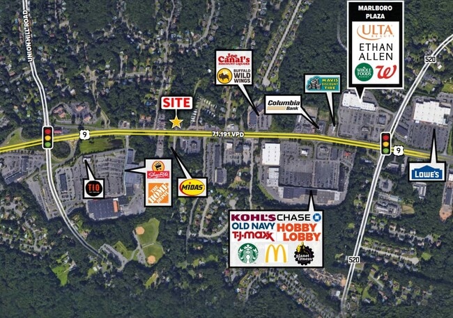
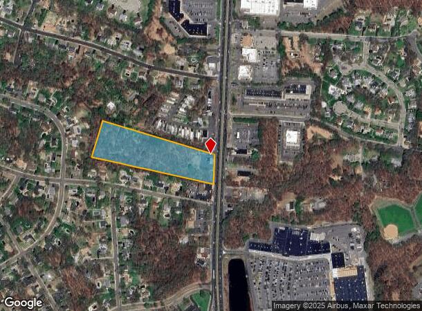
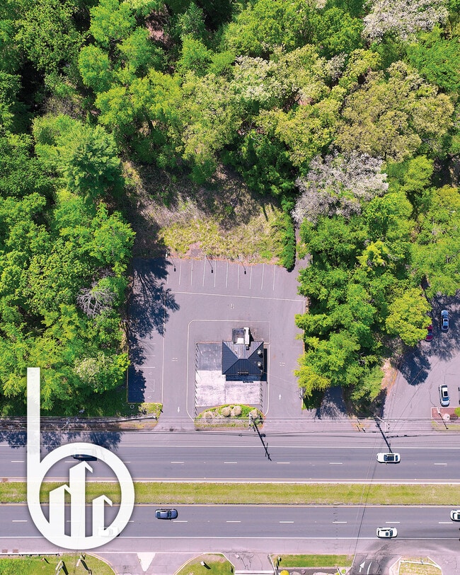
197 Us Highway 9, Englishtown, NJ 07726
Current Lease Availabilities
NEARBY LISTINGS FOR SALE OR LEASE
Property Detail
197 Us Highway 9
30-00275-0000-00053
Monmouth
Storebuilding
New Jersey
AE
53
34023C0281F
7.30 AC
2024
Western Monmouth
2025
Northern New Jersey
810102
New York-Jersey City-White Plains, NY-NJ
520 SF
DEMOGRAPHICS near 197 Us Highway 9
1 Mile
3 Mile
5 Mile
2024 Total Population
5,706
45,264
123,088
2029 Population
5,690
44,862
122,287
Pop Growth 2024-2029
(0.28%)
(0.89%)
(0.65%)
Average Age
46
44
43
2024 Total Households
2,231
16,002
42,896
HH Growth 2024-2029
(0.27%)
(0.90%)
(0.71%)
Median Household Inc
$108,833
$131,379
$125,759
Avg Household Size
2.50
2.70
2.80
2024 Avg HH Vehicles
2.00
2.00
2.00
Median Home Value
$539,956
$579,919
$522,631
Median Year Built
1980
1983
1982
Nearby Places
- Restaurants
- Banks
- Shops
- Fitness
- Groceries
PUBLIC TRANSPORTATION
COMMUTER RAIL
Aberdeen Matawan (North Jersey Coast Line - NJ Transit Commuter Rail (NJ Transit))
DRIVE
WALK
Distance
Aberdeen Matawan (North Jersey Coast Line - NJ Transit Commuter Rail (NJ Transit))
15 min
9.1 mi
AIRPORT
Newark Liberty International
DRIVE
WALK
Distance
Newark Liberty International
43 min
35.1 mi
Trenton Mercer
DRIVE
WALK
Distance
Trenton Mercer
54 min
35.4 mi
Freight Ports
New York Container Terminal
DRIVE
WALK
Distance
New York Container Terminal
36 min
27.3 mi
Nearby Properties
Address
Land Use
TOTAL SIZE
Lot Size
Zoning
Address
Land Use
TOTAL SIZE
Lot Size
Zoning
212,031 SF
23.97 AC
C3
Address
Land Use
TOTAL SIZE
Lot Size
Zoning
223,463 SF
41.75 AC
C-3
Address
Land Use
TOTAL SIZE
Lot Size
Zoning
12,614 SF
32.36 AC
IOR
Address
Land Use
TOTAL SIZE
Lot Size
Zoning
6.97 AC
C2
Address
Land Use
TOTAL SIZE
Lot Size
Zoning
144,977 SF
31.77 AC
C-4
Address
Land Use
TOTAL SIZE
Lot Size
Zoning
7,804 SF
12.82 AC
OG3
Address
Land Use
TOTAL SIZE
Lot Size
Zoning
8.15 AC
C2-M
Address
Land Use
TOTAL SIZE
Lot Size
Zoning
9.95 AC
Address
Land Use
TOTAL SIZE
Lot Size
Zoning
30.80 AC
CF
Address
Land Use
TOTAL SIZE
Lot Size
Zoning
7,804 SF
6.71 AC
OG1
Address
Land Use
TOTAL SIZE
Lot Size
Zoning
58,674 SF
44 SF
C-3
Address
Land Use
TOTAL SIZE
Lot Size
Zoning
58,024 SF
9.45 AC
C2
Address
Land Use
TOTAL SIZE
Lot Size
Zoning
10.86 AC
C-3
Address
Land Use
TOTAL SIZE
Lot Size
Zoning
134,850 SF
21.78 AC
C-4
Address
Land Use
TOTAL SIZE
Lot Size
Zoning
13.82 AC
R120
Address
Land Use
TOTAL SIZE
Lot Size
Zoning
98,000 SF
7.52 AC
7663
Address
Land Use
TOTAL SIZE
Lot Size
Zoning
17,342 SF
64.55 AC
ROS
Address
Land Use
TOTAL SIZE
Lot Size
Zoning
6.37 AC
C2
Address
Land Use
TOTAL SIZE
Lot Size
Zoning
21.35 AC
CF
Address
Land Use
TOTAL SIZE
Lot Size
Zoning
6.68 AC
C3
Address
Land Use
TOTAL SIZE
Lot Size
Zoning
7,702 SF
23 AC
AF
Address
Land Use
TOTAL SIZE
Lot Size
Zoning
0.90 AC
R-1
Address
Land Use
TOTAL SIZE
Lot Size
Zoning
32.37 AC
CF
Address
Land Use
TOTAL SIZE
Lot Size
Zoning
17.70 AC
PB
Address
Land Use
TOTAL SIZE
Lot Size
Zoning
10.02 AC
Address
Land Use
TOTAL SIZE
Lot Size
Zoning
7,702 SF
20.75 AC
AF
Address
Land Use
TOTAL SIZE
Lot Size
Zoning
2.62 AC
OB10
Address
Land Use
TOTAL SIZE
Lot Size
Zoning
29,200 SF
7.48 AC
C-3
Address
Land Use
TOTAL SIZE
Lot Size
Zoning
750 SF
280.39 AC
SD5
Address
Land Use
TOTAL SIZE
Lot Size
Zoning
6.60 AC
C50
The World's #1 Commercial Real Estate Marketplace
Connect with us
© 2025 CoStar Group
The information above has been obtained from sources believed reliable. While we do not doubt its accuracy we have not verified it and make no guarantee, warranty or representation about it. It is your responsibility to independently confirm its accuracy and completeness. Any projections, opinions, assumptions, or estimates used are for example only and do not represent the current or future performance of the property. The value of this transaction to you depends on tax and other factors which should be evaluated by your tax, financial, and legal advisors. You and your advisors should conduct a careful, independent investigation of the property to determine to your satisfaction the suitability of the property for your needs.