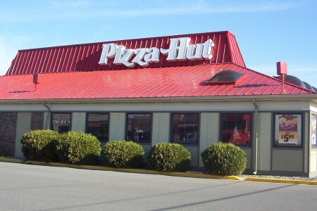
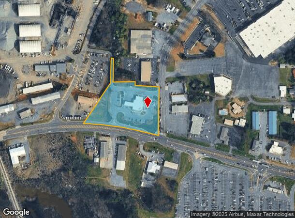
Property Record
197 Wc Bryant Pkwy, Calhoun, GA 30701
NEARBY LISTINGS FOR SALE OR LEASE
Property Detail
197 Wc Bryant Pkwy
C28-037
143X462
Financialbuilding
Gordon
X
Georgia
13015C0050H
2.19 AC
2024
Georgia Northwest
2024
Other Market Areas
970602
Calhoun, GA
5,388 SF
DEMOGRAPHICS near 197 Wc Bryant Pkwy
1 Mile
3 Mile
5 Mile
2024 Total Population
3,155
20,905
33,961
2029 Population
3,355
22,405
36,365
Pop Growth 2024-2029
+ 6.34%
+ 7.18%
+ 7.08%
Average Age
37
39
39
2024 Total Households
1,164
7,995
12,596
HH Growth 2024-2029
+ 6.01%
+ 6.93%
+ 6.88%
Median Household Inc
$41,809
$44,021
$46,826
Avg Household Size
2.60
2.50
2.60
2024 Avg HH Vehicles
2.00
2.00
2.00
Median Home Value
$160,067
$179,904
$178,718
Median Year Built
1974
1983
1987
Nearby Places
- Restaurants
- Banks
- Shops
- Fitness
- Groceries
Nearby Properties
Address
Land Use
TOTAL SIZE
Lot Size
Zoning
Address
Land Use
TOTAL SIZE
Lot Size
Zoning
5,040 SF
13.39 AC
C-2
Address
Land Use
TOTAL SIZE
Lot Size
Zoning
215,296 SF
19.94 AC
R-2
Address
Land Use
TOTAL SIZE
Lot Size
Zoning
403,152 SF
8.33 AC
Address
Land Use
TOTAL SIZE
Lot Size
Zoning
209,387 SF
42.22 AC
R-1
Address
Land Use
TOTAL SIZE
Lot Size
Zoning
18,640 SF
75.10 AC
C-2
Address
Land Use
TOTAL SIZE
Lot Size
Zoning
192,578 SF
25.47 AC
C-N
Address
Land Use
TOTAL SIZE
Lot Size
Zoning
197,500 SF
14.55 AC
IND-G
Address
Land Use
TOTAL SIZE
Lot Size
Zoning
85,560 SF
3 AC
C-2
Address
Land Use
TOTAL SIZE
Lot Size
Zoning
4,318 SF
19.26 AC
IND-G
Address
Land Use
TOTAL SIZE
Lot Size
Zoning
2,870 SF
11.02 AC
PRD
Address
Land Use
TOTAL SIZE
Lot Size
Zoning
26,922 SF
19.71 AC
C-4
Address
Land Use
TOTAL SIZE
Lot Size
Zoning
2,899 SF
12 AC
Address
Land Use
TOTAL SIZE
Lot Size
Zoning
3,360 SF
25.27 AC
RC-1
Address
Land Use
TOTAL SIZE
Lot Size
Zoning
554,897 SF
42.41 AC
IND-G
Address
Land Use
TOTAL SIZE
Lot Size
Zoning
88,000 SF
8.87 AC
IND-G
Address
Land Use
TOTAL SIZE
Lot Size
Zoning
128,740 SF
42.95 AC
IND-G
Address
Land Use
TOTAL SIZE
Lot Size
Zoning
806,290 SF
74.96 AC
IND-G
Address
Land Use
TOTAL SIZE
Lot Size
Zoning
28,481 SF
24.41 AC
R-1B
Address
Land Use
TOTAL SIZE
Lot Size
Zoning
6,956 SF
7 AC
R-2
Address
Land Use
TOTAL SIZE
Lot Size
Zoning
281,810 SF
22.74 AC
IND-G
Address
Land Use
TOTAL SIZE
Lot Size
Zoning
96,533 SF
3.53 AC
R-2
Address
Land Use
TOTAL SIZE
Lot Size
Zoning
4,357 SF
34.97 AC
R-2
Address
Land Use
TOTAL SIZE
Lot Size
Zoning
207,900 SF
13.43 AC
IND-G
Address
Land Use
TOTAL SIZE
Lot Size
Zoning
63,612 SF
8.67 AC
I1
Address
Land Use
TOTAL SIZE
Lot Size
Zoning
73,792 SF
5.38 AC
C-2
Address
Land Use
TOTAL SIZE
Lot Size
Zoning
16,424 SF
5.73 AC
MU
Address
Land Use
TOTAL SIZE
Lot Size
Zoning
17,685 SF
25.67 AC
C-2
Address
Land Use
TOTAL SIZE
Lot Size
Zoning
51.30 AC
IND-G
Address
Land Use
TOTAL SIZE
Lot Size
Zoning
67,800 SF
10.53 AC
I-1
Address
Land Use
TOTAL SIZE
Lot Size
Zoning
16,274 SF
12.25 AC
CU
The World's #1 Commercial Real Estate Marketplace
Connect with us
© 2025 CoStar Group
The information above has been obtained from sources believed reliable. While we do not doubt its accuracy we have not verified it and make no guarantee, warranty or representation about it. It is your responsibility to independently confirm its accuracy and completeness. Any projections, opinions, assumptions, or estimates used are for example only and do not represent the current or future performance of the property. The value of this transaction to you depends on tax and other factors which should be evaluated by your tax, financial, and legal advisors. You and your advisors should conduct a careful, independent investigation of the property to determine to your satisfaction the suitability of the property for your needs.