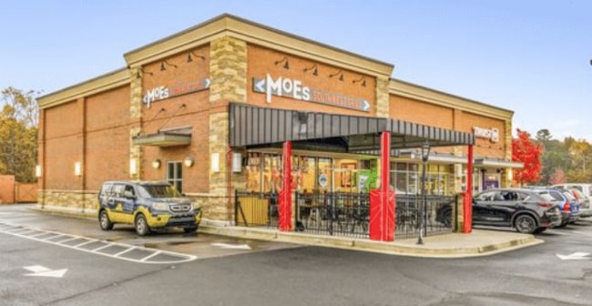
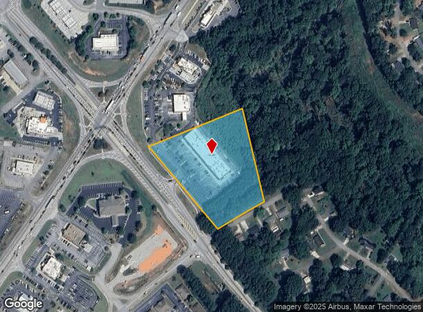
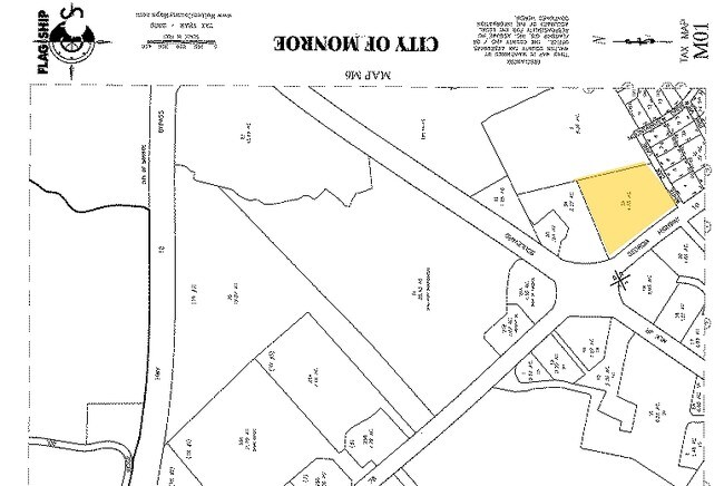
Property Record
1970 W Spring St, Monroe, GA 30655
Current Lease Availabilities
NEARBY LISTINGS FOR SALE OR LEASE
Property Detail
1970 W Spring St
M001000000003A00
09040-Sf-Monroe Business
Commercialnec
#3 4.55AC
AE
Walton
13297C0136E
Georgia
2024
4.55 AC
2025
Walton County
110400
Atlanta
18,200 SF
Atlanta-Sandy Springs-Roswell, GA
DEMOGRAPHICS near 1970 W Spring St
1 Mile
3 Mile
5 Mile
2024 Total Population
1,968
22,095
36,620
2029 Population
2,252
25,637
42,465
Pop Growth 2024-2029
+ 14.43%
+ 16.03%
+ 15.96%
Average Age
38
39
40
2024 Total Households
796
8,315
13,433
HH Growth 2024-2029
+ 14.82%
+ 16.43%
+ 16.36%
Median Household Inc
$48,653
$46,818
$60,415
Avg Household Size
2.50
2.60
2.70
2024 Avg HH Vehicles
2.00
2.00
2.00
Median Home Value
$224,138
$229,849
$249,302
Median Year Built
1983
1988
1992
Nearby Places
Map Layers
Map Styles
 Street
 Aerial
- Restaurants
- Banks
- Shops
- Fitness
- Groceries
Nearby Properties
Address
Land Use
TOTAL SIZE
Lot Size
Zoning
Address
Land Use
TOTAL SIZE
Lot Size
Zoning
117,471 SF
65.68 AC
B3
Address
Land Use
TOTAL SIZE
Lot Size
Zoning
174,303 SF
26.22 AC
PCD
Address
Land Use
TOTAL SIZE
Lot Size
Zoning
35,900 SF
44.30 AC
B3
Address
Land Use
TOTAL SIZE
Lot Size
Zoning
9,424 SF
76 AC
MIX WP2
Address
Land Use
TOTAL SIZE
Lot Size
Zoning
122,949 SF
28.37 AC
R1 P
Address
Land Use
TOTAL SIZE
Lot Size
Zoning
188,663 SF
25.40 AC
B3
Address
Land Use
TOTAL SIZE
Lot Size
Zoning
319.22 AC
B3 R1
Address
Land Use
TOTAL SIZE
Lot Size
Zoning
2,736 SF
8.96 AC
P
Address
Land Use
TOTAL SIZE
Lot Size
Zoning
96,107 SF
58.49 AC
R1
Address
Land Use
TOTAL SIZE
Lot Size
Zoning
29,161 SF
42.44 AC
B2 R1 R2
Address
Land Use
TOTAL SIZE
Lot Size
Zoning
4,319 SF
12.16 AC
PRD
Address
Land Use
TOTAL SIZE
Lot Size
Zoning
96,129 SF
32.74 AC
A1
Address
Land Use
TOTAL SIZE
Lot Size
Zoning
78,644 SF
9.90 AC
B3
Address
Land Use
TOTAL SIZE
Lot Size
Zoning
58,980 SF
8.84 AC
PCD
Address
Land Use
TOTAL SIZE
Lot Size
Zoning
39,385 SF
38.48 AC
B3
Address
Land Use
TOTAL SIZE
Lot Size
Zoning
104,716 SF
11.70 AC
B3
Address
Land Use
TOTAL SIZE
Lot Size
Zoning
2,640 SF
64.81 AC
R1A
Address
Land Use
TOTAL SIZE
Lot Size
Zoning
12,240 SF
7.16 AC
B3
Address
Land Use
TOTAL SIZE
Lot Size
Zoning
2,900 SF
30.02 AC
M1
Address
Land Use
TOTAL SIZE
Lot Size
Zoning
52,185 SF
3.64 AC
PCD
Address
Land Use
TOTAL SIZE
Lot Size
Zoning
27,300 SF
8 AC
PCD
Address
Land Use
TOTAL SIZE
Lot Size
Zoning
45,428 SF
8.11 AC
B3
Address
Land Use
TOTAL SIZE
Lot Size
Zoning
25,192 SF
20.20 AC
A2
Address
Land Use
TOTAL SIZE
Lot Size
Zoning
90,557 SF
11.46 AC
B3
Address
Land Use
TOTAL SIZE
Lot Size
Zoning
104,104 SF
17.55 AC
R1A
Address
Land Use
TOTAL SIZE
Lot Size
Zoning
37,600 SF
5.96 AC
B2
Address
Land Use
TOTAL SIZE
Lot Size
Zoning
3,321 SF
9.58 AC
M1
Address
Land Use
TOTAL SIZE
Lot Size
Zoning
3,912 SF
221.14 AC
MIX
Address
Land Use
TOTAL SIZE
Lot Size
Zoning
2,576 SF
23.95 AC
I1
Address
Land Use
TOTAL SIZE
Lot Size
Zoning
24,553 SF
5.32 AC
P
The World's #1 Commercial Real Estate Marketplace
Connect with us
© 2026 CoStar Group
The information above has been obtained from sources believed reliable. While we do not doubt its accuracy we have not verified it and make no guarantee, warranty or representation about it. It is your responsibility to independently confirm its accuracy and completeness. Any projections, opinions, assumptions, or estimates used are for example only and do not represent the current or future performance of the property. The value of this transaction to you depends on tax and other factors which should be evaluated by your tax, financial, and legal advisors. You and your advisors should conduct a careful, independent investigation of the property to determine to your satisfaction the suitability of the property for your needs.