Property Record
Tyler Island Rd, Walnut Grove, CA 95690
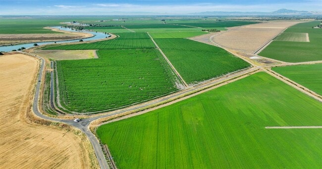
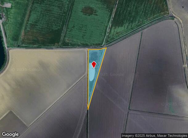
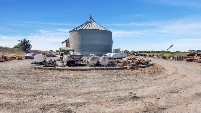
This Property Is For Sale
NEARBY LISTINGS FOR SALE OR LEASE
-
-
View all Walnut Grove listings for sale on LoopNet.com
Property Detail
Tyler Island Rd
Sacramento--Roseville--Arden-Arcade, CA
Swamp Land Surv 489
156-0030-014
POR OF SLS 964, LOC IN THE NW 1/4 OF SEC 15, T4N, R4E, MDB&M,DESC AS: BEG AT S.P.R.R. ENGR STA P-1, 1581 +22/08 ON THE C/LOF
Residentialacreage
Sacramento
AE
California
06067C0560H
5.50 AC
2024
Outer Sacramento County
2025
Sacramento
009900
DEMOGRAPHICS near Tyler Island Rd
1 Mile
3 Mile
5 Mile
2024 Total Population
0
151
2,609
2029 Population
0
136
2,431
Pop Growth 2024-2029
0.00%
(9.93%)
(6.82%)
Average Age
0
42
43
2024 Total Households
0
51
974
HH Growth 2024-2029
0.00%
(9.80%)
(6.88%)
Median Household Inc
$0
$146,249
$70,988
Avg Household Size
.00
2.90
2.60
2024 Avg HH Vehicles
.00
3.00
2.00
Median Home Value
$0
$909,090
$655,923
Median Year Built
0
1965
1970
Nearby Places
- Restaurants
- Banks
- Shops
- Fitness
- Groceries
PUBLIC TRANSPORTATION
AIRPORT
Stockton Metro
DRIVE
WALK
Distance
Stockton Metro
54 min
35.9 mi
Freight Ports
Port of Stockton
DRIVE
WALK
Distance
Port of Stockton
44 min
28.4 mi
Nearby Properties
Address
Land Use
TOTAL SIZE
Lot Size
Zoning
Address
Land Use
TOTAL SIZE
Lot Size
Zoning
9.07 AC
AG40
Address
Land Use
TOTAL SIZE
Lot Size
Zoning
2,272 SF
579.06 AC
AG40
Address
Land Use
TOTAL SIZE
Lot Size
Zoning
2,338 SF
59.20 AC
AG-40
Address
Land Use
TOTAL SIZE
Lot Size
Zoning
2,492 SF
214.26 AC
DW-S AG-80
Address
Land Use
TOTAL SIZE
Lot Size
Zoning
56,352 SF
9.66 AC
M-2 AG-80
Address
Land Use
TOTAL SIZE
Lot Size
Zoning
2,700 SF
91.93 AC
AG-20
Address
Land Use
TOTAL SIZE
Lot Size
Zoning
720.47 AC
AG-80
Address
Land Use
TOTAL SIZE
Lot Size
Zoning
423 AC
AG40
Address
Land Use
TOTAL SIZE
Lot Size
Zoning
936 SF
120.76 AC
AG-80
Address
Land Use
TOTAL SIZE
Lot Size
Zoning
4.52 AC
M-2
Address
Land Use
TOTAL SIZE
Lot Size
Zoning
89.36 AC
AG-80 DW-S
Address
Land Use
TOTAL SIZE
Lot Size
Zoning
3,146 SF
113.38 AC
AG-80 DW-S
Address
Land Use
TOTAL SIZE
Lot Size
Zoning
1,548 SF
39.45 AC
AG-20
Address
Land Use
TOTAL SIZE
Lot Size
Zoning
133.45 AC
AG-80
Address
Land Use
TOTAL SIZE
Lot Size
Zoning
512 SF
4.03 AC
AG40
Address
Land Use
TOTAL SIZE
Lot Size
Zoning
40 AC
AG-40 LC
Address
Land Use
TOTAL SIZE
Lot Size
Zoning
7,950 SF
35 AC
AG-20
Address
Land Use
TOTAL SIZE
Lot Size
Zoning
1,170 SF
546.56 AC
AG-80
Address
Land Use
TOTAL SIZE
Lot Size
Zoning
2,738 SF
143.75 AC
AG-40
Address
Land Use
TOTAL SIZE
Lot Size
Zoning
29,280 SF
5.10 AC
M-2 AG-20
Address
Land Use
TOTAL SIZE
Lot Size
Zoning
64.75 AC
AG-40
Address
Land Use
TOTAL SIZE
Lot Size
Zoning
100.15 AC
AG-80
Address
Land Use
TOTAL SIZE
Lot Size
Zoning
2,212 SF
99.34 AC
AG-80
Address
Land Use
TOTAL SIZE
Lot Size
Zoning
16,662 SF
7.96 AC
DW LC AR-5
Address
Land Use
TOTAL SIZE
Lot Size
Zoning
99.30 AC
AG-40
Address
Land Use
TOTAL SIZE
Lot Size
Zoning
2,058 SF
59.39 AC
AG-40
Address
Land Use
TOTAL SIZE
Lot Size
Zoning
2,054 SF
98.04 AC
AG-80 DW-S
Address
Land Use
TOTAL SIZE
Lot Size
Zoning
87 AC
AG-80
Address
Land Use
TOTAL SIZE
Lot Size
Zoning
2,804 SF
2 AC
AG-80
Address
Land Use
TOTAL SIZE
Lot Size
Zoning
2,644 SF
2.09 AC
DW-S AG-80
The World's #1 Commercial Real Estate Marketplace
Connect with us
© 2025 CoStar Group
The information above has been obtained from sources believed reliable. While we do not doubt its accuracy we have not verified it and make no guarantee, warranty or representation about it. It is your responsibility to independently confirm its accuracy and completeness. Any projections, opinions, assumptions, or estimates used are for example only and do not represent the current or future performance of the property. The value of this transaction to you depends on tax and other factors which should be evaluated by your tax, financial, and legal advisors. You and your advisors should conduct a careful, independent investigation of the property to determine to your satisfaction the suitability of the property for your needs.