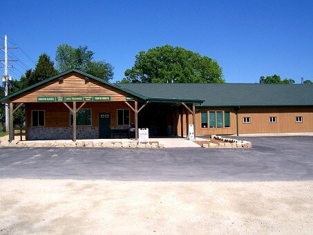
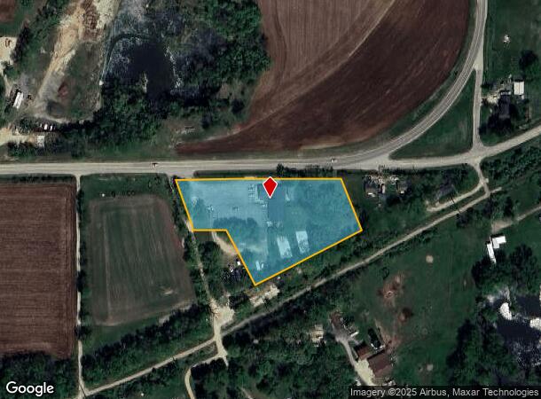
Property Record
1931 Il Route 75 E, Freeport, IL 61032

NEARBY LISTINGS FOR SALE OR LEASE
Property Detail
1931 Il Route 75 E
Freeport, IL
Wrightwood Subdivision
07-14-28-476-014
LTS 3-6 & PT LTS 7-9 WRIGHTWOOD SUB SE SE SEC 28-27-9
Commercialnec
Stephenson
X
Illinois
17177C0337D
3-9
2024
3.02 AC
2024
Illinois North Area
000700
Other Market Areas
DEMOGRAPHICS near 1931 Il Route 75 E
1 Mile
3 Mile
5 Mile
2024 Total Population
259
12,521
26,597
2029 Population
254
12,441
26,094
Pop Growth 2024-2029
(1.93%)
(0.64%)
(1.89%)
Average Age
42
39
43
2024 Total Households
113
5,209
11,634
HH Growth 2024-2029
(1.77%)
(0.71%)
(2.00%)
Median Household Inc
$42,083
$37,983
$45,363
Avg Household Size
2.30
2.30
2.20
2024 Avg HH Vehicles
2.00
1.00
1.00
Median Home Value
$98,780
$59,302
$80,279
Median Year Built
1955
1948
1958
Nearby Places
Map Layers
Map Styles
 Street
 Aerial
- Restaurants
- Banks
- Shops
- Fitness
- Groceries
PUBLIC TRANSPORTATION
AIRPORT
Chicago/Rockford International
DRIVE
WALK
Distance
Chicago/Rockford International
45 min
32.9 mi
SALE & LEASE HISTORY
LISTING DATE
SALE/LEASE

Sep 25, 2016
For Lease
Sep 23, 2016
For Sale
Nearby Properties
Address
Land Use
TOTAL SIZE
Lot Size
Zoning
Address
Land Use
TOTAL SIZE
Lot Size
Zoning
499,200 SF
36.03 AC
Address
Land Use
TOTAL SIZE
Lot Size
Zoning
128.28 AC
Address
Land Use
TOTAL SIZE
Lot Size
Zoning
Address
Land Use
TOTAL SIZE
Lot Size
Zoning
148.08 AC
Address
Land Use
TOTAL SIZE
Lot Size
Zoning
4.13 AC
Address
Land Use
TOTAL SIZE
Lot Size
Zoning
38.59 AC
Address
Land Use
TOTAL SIZE
Lot Size
Zoning
7,754 SF
0.61 AC
Address
Land Use
TOTAL SIZE
Lot Size
Zoning
28.06 AC
Address
Land Use
TOTAL SIZE
Lot Size
Zoning
1.77 AC
Address
Land Use
TOTAL SIZE
Lot Size
Zoning
19.66 AC
Address
Land Use
TOTAL SIZE
Lot Size
Zoning
15.25 AC
Address
Land Use
TOTAL SIZE
Lot Size
Zoning
9.08 AC
Address
Land Use
TOTAL SIZE
Lot Size
Zoning
2.53 AC
Address
Land Use
TOTAL SIZE
Lot Size
Zoning
27,502 SF
0.83 AC
Address
Land Use
TOTAL SIZE
Lot Size
Zoning
Address
Land Use
TOTAL SIZE
Lot Size
Zoning
Address
Land Use
TOTAL SIZE
Lot Size
Zoning
Address
Land Use
TOTAL SIZE
Lot Size
Zoning
0.38 AC
Address
Land Use
TOTAL SIZE
Lot Size
Zoning
7,000 SF
4.87 AC
Address
Land Use
TOTAL SIZE
Lot Size
Zoning
16.60 AC
Address
Land Use
TOTAL SIZE
Lot Size
Zoning
11,868 SF
0.99 AC
Address
Land Use
TOTAL SIZE
Lot Size
Zoning
19.12 AC
Address
Land Use
TOTAL SIZE
Lot Size
Zoning
1,672 SF
5.03 AC
Address
Land Use
TOTAL SIZE
Lot Size
Zoning
8,000 SF
14.36 AC
Address
Land Use
TOTAL SIZE
Lot Size
Zoning
21,840 SF
8 AC
Address
Land Use
TOTAL SIZE
Lot Size
Zoning
10,269 SF
3.44 AC
Address
Land Use
TOTAL SIZE
Lot Size
Zoning
7,272 SF
1.33 AC
Address
Land Use
TOTAL SIZE
Lot Size
Zoning
0.44 AC
Address
Land Use
TOTAL SIZE
Lot Size
Zoning
2.97 AC
Address
Land Use
TOTAL SIZE
Lot Size
Zoning
3,344 SF
187.28 AC
The World's #1 Commercial Real Estate Marketplace
Connect with us
© 2026 CoStar Group
The information above has been obtained from sources believed reliable. While we do not doubt its accuracy we have not verified it and make no guarantee, warranty or representation about it. It is your responsibility to independently confirm its accuracy and completeness. Any projections, opinions, assumptions, or estimates used are for example only and do not represent the current or future performance of the property. The value of this transaction to you depends on tax and other factors which should be evaluated by your tax, financial, and legal advisors. You and your advisors should conduct a careful, independent investigation of the property to determine to your satisfaction the suitability of the property for your needs.