Property Record
19715 E 6Th St, Tulsa, OK 74108
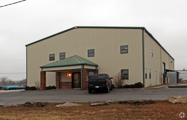

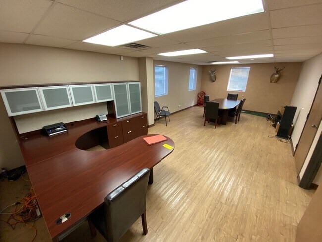

Property Detail
19715 E 6Th St
Tulsa, OK
PORT AREA INDUSTRIAL PARK LOT 12 BLK 2
730011663
Wagoner
Manufacturinglight
Oklahoma
B and X Area of moderate flood hazard, usually the area between the limits of the 100-year and 500-year floods.
12
2025
1.27 AC
2025
Wagoner County
030403
Tulsa
11,856 SF
NEARBY LISTINGS FOR SALE OR LEASE
DEMOGRAPHICS near 19715 E 6Th St
1 mile
3 mile
5 mile
2025 Total Population
3,213
13,592
57,682
2030 Population
3,417
14,486
60,750
Pop Growth 2025-2030
+ 6.35%
+ 6.58%
+ 5.32%
Average Age
38
38
37
2025 Total Households
1,260
5,010
20,795
HH Growth 2025-2030
+ 6.27%
+ 6.39%
+ 5.28%
Median Household Inc
$65,365
$76,726
$76,313
Avg Household Size
2.50
2.70
2.70
2025 Avg HH Vehicles
2.00
2.00
2.00
Median Home Value
$129,536
$214,681
$227,863
Median Year Built
1972
1988
1993
Nearby Places
Map Layers
Map Styles
 Street
 Aerial
Transit
 Traffic
 Biking
Places
Listings with unknown addresses are not visible on the map
- Restaurants
- Banks
- Shops
- Fitness
- Groceries
PUBLIC TRANSPORTATION
AIRPORT
Tulsa International
Drive
Walk
Distance
Tulsa International
20 min
13.2 mi
Freight Ports
Tulsa Port Of Catoosa
Drive
Walk
Distance
Tulsa Port Of Catoosa
13 min
6.9 mi
SALE & LEASE HISTORY
LISTING DATE
SALE/LEASE

Mar 31, 2022
For Sale
Nearby Properties
Address
Land Use
TOTAL SIZE
Lot Size
Zoning
Address
Land Use
TOTAL SIZE
Lot Size
Zoning
39,375 SF
70 AC
AG
Address
Land Use
TOTAL SIZE
Lot Size
Zoning
129,087 SF
43.40 AC
IR
Address
Land Use
TOTAL SIZE
Lot Size
Zoning
3,720 SF
158.66 AC
Address
Land Use
TOTAL SIZE
Lot Size
Zoning
2,852 SF
12.13 AC
Address
Land Use
TOTAL SIZE
Lot Size
Zoning
16,250 SF
76.36 AC
AG
Address
Land Use
TOTAL SIZE
Lot Size
Zoning
62,644 SF
12 AC
Address
Land Use
TOTAL SIZE
Lot Size
Zoning
2,842 SF
89.24 AC
AG
Address
Land Use
TOTAL SIZE
Lot Size
Zoning
153,297 SF
16.29 AC
Address
Land Use
TOTAL SIZE
Lot Size
Zoning
103,820 SF
2.50 AC
Address
Land Use
TOTAL SIZE
Lot Size
Zoning
7,584 SF
16.13 AC
AG
Address
Land Use
TOTAL SIZE
Lot Size
Zoning
Address
Land Use
TOTAL SIZE
Lot Size
Zoning
1 SF
80 AC
AG
Address
Land Use
TOTAL SIZE
Lot Size
Zoning
133,875 SF
7.68 AC
Address
Land Use
TOTAL SIZE
Lot Size
Zoning
2,210 SF
58.48 AC
AG
Address
Land Use
TOTAL SIZE
Lot Size
Zoning
87,500 SF
4.12 AC
IL
Address
Land Use
TOTAL SIZE
Lot Size
Zoning
15,925 SF
10.88 AC
AG
Address
Land Use
TOTAL SIZE
Lot Size
Zoning
14,196 SF
1.75 AC
RS1
Address
Land Use
TOTAL SIZE
Lot Size
Zoning
12,294 SF
1.57 AC
RS3
Address
Land Use
TOTAL SIZE
Lot Size
Zoning
15,523 SF
7 AC
AG
Address
Land Use
TOTAL SIZE
Lot Size
Zoning
4,279 SF
40 AC
AG
Address
Land Use
TOTAL SIZE
Lot Size
Zoning
58,610 SF
4.46 AC
Address
Land Use
TOTAL SIZE
Lot Size
Zoning
2,456 SF
2.18 AC
Address
Land Use
TOTAL SIZE
Lot Size
Zoning
68,725 SF
2.73 AC
Address
Land Use
TOTAL SIZE
Lot Size
Zoning
1,440 SF
4.84 AC
Address
Land Use
TOTAL SIZE
Lot Size
Zoning
11,115 SF
2.61 AC
RS3
Address
Land Use
TOTAL SIZE
Lot Size
Zoning
450 AC
AG
Address
Land Use
TOTAL SIZE
Lot Size
Zoning
57,268 SF
6.87 AC
Address
Land Use
TOTAL SIZE
Lot Size
Zoning
60,000 SF
11.53 AC
Address
Land Use
TOTAL SIZE
Lot Size
Zoning
6,568 SF
6.51 AC
RS1
Address
Land Use
TOTAL SIZE
Lot Size
Zoning
9,710 SF
3.91 AC
RS3
The World's #1 Commercial Real Estate Marketplace
Connect with us
© 2026 CoStar Group
The information above has been obtained from sources believed reliable. While we do not doubt its accuracy we have not verified it and make no guarantee, warranty or representation about it. It is your responsibility to independently confirm its accuracy and completeness. Any projections, opinions, assumptions, or estimates used are for example only and do not represent the current or future performance of the property. The value of this transaction to you depends on tax and other factors which should be evaluated by your tax, financial, and legal advisors. You and your advisors should conduct a careful, independent investigation of the property to determine to your satisfaction the suitability of the property for your needs.