Property Record
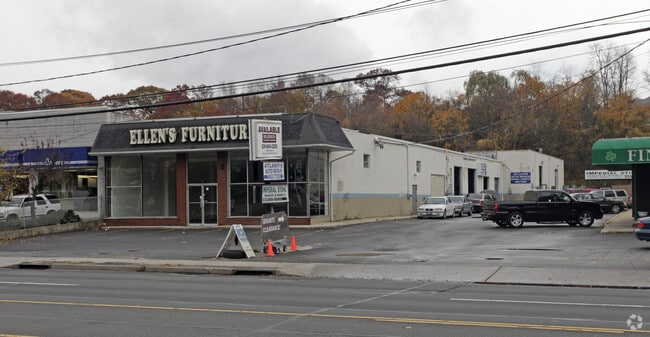
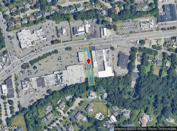
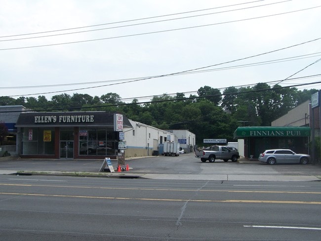
1972-1976 Jericho Tpke, East Northport, NY 11731
NEARBY LISTINGS FOR SALE OR LEASE
Property Detail
1972-1976 Jericho Tpke
Nassau County-Suffolk County, NY
BLK LOT
0400-215-00-01-00-010-000
Suffolk
Bartavern
New York
X
10
36103C0630H
0.50 AC
2024
Western Suffolk
2024
Long Island (New York)
135201
DEMOGRAPHICS near 1972-1976 Jericho Tpke
1 Mile
3 Mile
5 Mile
2024 Total Population
6,579
70,742
208,895
2029 Population
6,487
69,523
204,834
Pop Growth 2024-2029
(1.40%)
(1.72%)
(1.94%)
Average Age
43
43
42
2024 Total Households
2,105
22,949
67,507
HH Growth 2024-2029
(1.71%)
(2.03%)
(2.16%)
Median Household Inc
$153,750
$154,353
$142,728
Avg Household Size
3.00
2.90
3.00
2024 Avg HH Vehicles
3.00
2.00
2.00
Median Home Value
$675,957
$674,239
$656,223
Median Year Built
1963
1963
1963
Nearby Places
- Restaurants
- Banks
- Shops
- Fitness
- Groceries
PUBLIC TRANSPORTATION
COMMUTER RAIL
Greenlawn Station (Port Jefferson Branch - Long Island Rail Road)
DRIVE
WALK
Distance
Greenlawn Station (Port Jefferson Branch - Long Island Rail Road)
7 min
3.3 mi
Northport Station (Port Jefferson Branch - Long Island Rail Road)
DRIVE
WALK
Distance
Northport Station (Port Jefferson Branch - Long Island Rail Road)
7 min
3.7 mi
AIRPORT
Long Island MacArthur
DRIVE
WALK
Distance
Long Island MacArthur
23 min
13.9 mi
John F Kennedy International
DRIVE
WALK
Distance
John F Kennedy International
50 min
35.5 mi
Freight Ports
NY - Red Hook Container Terminal
DRIVE
WALK
Distance
NY - Red Hook Container Terminal
61 min
41.8 mi
Nearby Properties
Address
Land Use
TOTAL SIZE
Lot Size
Zoning
Address
Land Use
TOTAL SIZE
Lot Size
Zoning
0.41 AC
VILLA
Address
Land Use
TOTAL SIZE
Lot Size
Zoning
1.50 AC
CR80
Address
Land Use
TOTAL SIZE
Lot Size
Zoning
21.50 AC
Address
Land Use
TOTAL SIZE
Lot Size
Zoning
82 AC
R40
Address
Land Use
TOTAL SIZE
Lot Size
Zoning
22.80 AC
Address
Land Use
TOTAL SIZE
Lot Size
Zoning
14.13 AC
Address
Land Use
TOTAL SIZE
Lot Size
Zoning
Address
Land Use
TOTAL SIZE
Lot Size
Zoning
12.30 AC
Address
Land Use
TOTAL SIZE
Lot Size
Zoning
17.20 AC
Address
Land Use
TOTAL SIZE
Lot Size
Zoning
88,200 SF
11.20 AC
Address
Land Use
TOTAL SIZE
Lot Size
Zoning
15.70 AC
Address
Land Use
TOTAL SIZE
Lot Size
Zoning
8.80 AC
R10
Address
Land Use
TOTAL SIZE
Lot Size
Zoning
6.50 AC
R40
Address
Land Use
TOTAL SIZE
Lot Size
Zoning
148.70 AC
R40
Address
Land Use
TOTAL SIZE
Lot Size
Zoning
42.20 AC
I1
Address
Land Use
TOTAL SIZE
Lot Size
Zoning
142,732 SF
16.90 AC
Address
Land Use
TOTAL SIZE
Lot Size
Zoning
9.30 AC
Address
Land Use
TOTAL SIZE
Lot Size
Zoning
44.90 AC
R40
Address
Land Use
TOTAL SIZE
Lot Size
Zoning
10.14 AC
RRM
Address
Land Use
TOTAL SIZE
Lot Size
Zoning
12.80 AC
Address
Land Use
TOTAL SIZE
Lot Size
Zoning
19.77 AC
Address
Land Use
TOTAL SIZE
Lot Size
Zoning
44.70 AC
G
Address
Land Use
TOTAL SIZE
Lot Size
Zoning
12 AC
RRM
Address
Land Use
TOTAL SIZE
Lot Size
Zoning
19.90 AC
C5
Address
Land Use
TOTAL SIZE
Lot Size
Zoning
7.10 AC
Address
Land Use
TOTAL SIZE
Lot Size
Zoning
10.47 AC
Address
Land Use
TOTAL SIZE
Lot Size
Zoning
Address
Land Use
TOTAL SIZE
Lot Size
Zoning
180,224 SF
8.70 AC
GA
Address
Land Use
TOTAL SIZE
Lot Size
Zoning
9.80 AC
Address
Land Use
TOTAL SIZE
Lot Size
Zoning
48.76 AC
R40
The World's #1 Commercial Real Estate Marketplace
Connect with us
© 2025 CoStar Group
The information above has been obtained from sources believed reliable. While we do not doubt its accuracy we have not verified it and make no guarantee, warranty or representation about it. It is your responsibility to independently confirm its accuracy and completeness. Any projections, opinions, assumptions, or estimates used are for example only and do not represent the current or future performance of the property. The value of this transaction to you depends on tax and other factors which should be evaluated by your tax, financial, and legal advisors. You and your advisors should conduct a careful, independent investigation of the property to determine to your satisfaction the suitability of the property for your needs.