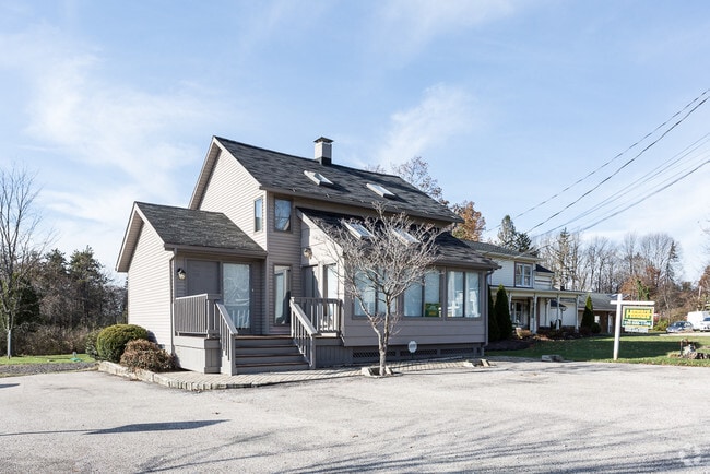
Property Record
1972 N Cleveland Massillon Rd, Akron, OH 44333
NEARBY LISTINGS FOR SALE OR LEASE
Property Detail
1972 N Cleveland Massillon Rd
04-03915
LOT 16 W OF CLEVE MASS RD 0.22AC 52.05 FT. FRT.
Medicalbuilding
Summit
X
Ohio
39153C0085F
16
2023
0.18 AC
2025
Akron
532301
Cleveland
1,476 SF
Akron, OH
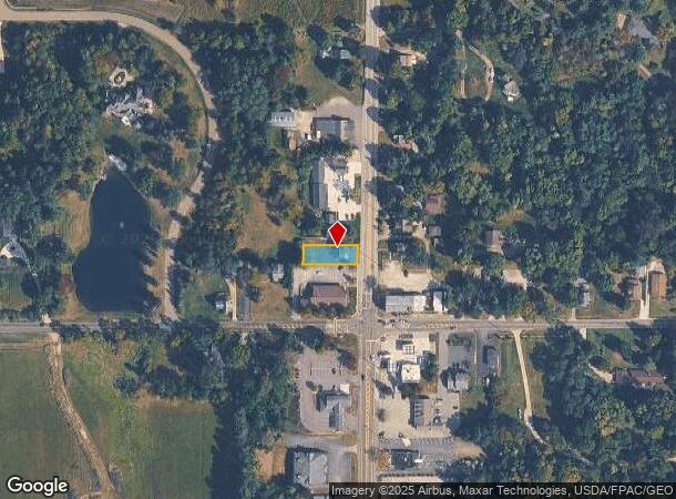
DEMOGRAPHICS near 1972 N Cleveland Massillon Rd
1 Mile
3 Mile
5 Mile
2024 Total Population
863
8,371
34,476
2029 Population
835
8,192
34,060
Pop Growth 2024-2029
(3.24%)
(2.14%)
(1.21%)
Average Age
43
45
45
2024 Total Households
309
3,239
14,157
HH Growth 2024-2029
(3.24%)
(2.19%)
(1.26%)
Median Household Inc
$142,372
$133,907
$107,506
Avg Household Size
2.70
2.50
2.40
2024 Avg HH Vehicles
2.00
2.00
2.00
Median Home Value
$605,263
$437,474
$328,826
Median Year Built
1989
1973
1978
Nearby Places
Map Layers
Map Styles
 Street
 Aerial
- Restaurants
- Banks
- Shops
- Fitness
- Groceries
PUBLIC TRANSPORTATION
COMMUTER RAIL
DRIVE
WALK
Distance
10 min
4.2 mi
DRIVE
WALK
Distance
11 min
5.3 mi
AIRPORT
Cleveland-Hopkins International
DRIVE
WALK
Distance
Cleveland-Hopkins International
41 min
26.9 mi
Akron-Canton Regional
DRIVE
WALK
Distance
Akron-Canton Regional
37 min
27.1 mi
SALE & LEASE HISTORY
LISTING DATE
SALE/LEASE

Nov 28, 2017
For Sale
Nearby Properties
Address
Land Use
TOTAL SIZE
Lot Size
Zoning
Address
Land Use
TOTAL SIZE
Lot Size
Zoning
12.92 AC
Address
Land Use
TOTAL SIZE
Lot Size
Zoning
254,133 SF
38.60 AC
Address
Land Use
TOTAL SIZE
Lot Size
Zoning
164,214 SF
12.92 AC
Address
Land Use
TOTAL SIZE
Lot Size
Zoning
Address
Land Use
TOTAL SIZE
Lot Size
Zoning
54,592 SF
11.32 AC
Address
Land Use
TOTAL SIZE
Lot Size
Zoning
216,612 SF
16.89 AC
Address
Land Use
TOTAL SIZE
Lot Size
Zoning
72,796 SF
11.49 AC
Address
Land Use
TOTAL SIZE
Lot Size
Zoning
87,704 SF
10.02 AC
Address
Land Use
TOTAL SIZE
Lot Size
Zoning
49,530 SF
8.28 AC
Address
Land Use
TOTAL SIZE
Lot Size
Zoning
54,750 SF
8.88 AC
Address
Land Use
TOTAL SIZE
Lot Size
Zoning
111,679 SF
30.05 AC
Address
Land Use
TOTAL SIZE
Lot Size
Zoning
87,684 SF
7.19 AC
Address
Land Use
TOTAL SIZE
Lot Size
Zoning
99,468 SF
10.04 AC
Address
Land Use
TOTAL SIZE
Lot Size
Zoning
48,928 SF
5.33 AC
Address
Land Use
TOTAL SIZE
Lot Size
Zoning
5,172 SF
370 AC
Address
Land Use
TOTAL SIZE
Lot Size
Zoning
58,977 SF
2.19 AC
Address
Land Use
TOTAL SIZE
Lot Size
Zoning
Address
Land Use
TOTAL SIZE
Lot Size
Zoning
105,120 SF
8.34 AC
Address
Land Use
TOTAL SIZE
Lot Size
Zoning
42,306 SF
2.82 AC
Address
Land Use
TOTAL SIZE
Lot Size
Zoning
55,070 SF
7 AC
Address
Land Use
TOTAL SIZE
Lot Size
Zoning
Address
Land Use
TOTAL SIZE
Lot Size
Zoning
Address
Land Use
TOTAL SIZE
Lot Size
Zoning
34,908 SF
4.33 AC
Address
Land Use
TOTAL SIZE
Lot Size
Zoning
59,852 SF
7 AC
Address
Land Use
TOTAL SIZE
Lot Size
Zoning
43,090 SF
4.02 AC
Address
Land Use
TOTAL SIZE
Lot Size
Zoning
57,294 SF
9.47 AC
Address
Land Use
TOTAL SIZE
Lot Size
Zoning
81,134 SF
61.23 AC
Address
Land Use
TOTAL SIZE
Lot Size
Zoning
Address
Land Use
TOTAL SIZE
Lot Size
Zoning
24,919 SF
26.34 AC
Address
Land Use
TOTAL SIZE
Lot Size
Zoning
100,659 SF
8.63 AC
The World's #1 Commercial Real Estate Marketplace
Connect with us
© 2025 CoStar Group
The information above has been obtained from sources believed reliable. While we do not doubt its accuracy we have not verified it and make no guarantee, warranty or representation about it. It is your responsibility to independently confirm its accuracy and completeness. Any projections, opinions, assumptions, or estimates used are for example only and do not represent the current or future performance of the property. The value of this transaction to you depends on tax and other factors which should be evaluated by your tax, financial, and legal advisors. You and your advisors should conduct a careful, independent investigation of the property to determine to your satisfaction the suitability of the property for your needs.