Property Record
19727 W Interstate 10, San Antonio, TX 78257
NEARBY LISTINGS FOR SALE OR LEASE
-
-
-
-
-
-
-
-
-
22137 Interstate 10 (STONEWALL PKWY)
San Antonio, TX 78257
$1,594,936 - $3,649,147
1.91 - 2.46 AC Lot
Land
-
-
-
-
-
-
-
View all San Antonio listings for sale on LoopNet.com
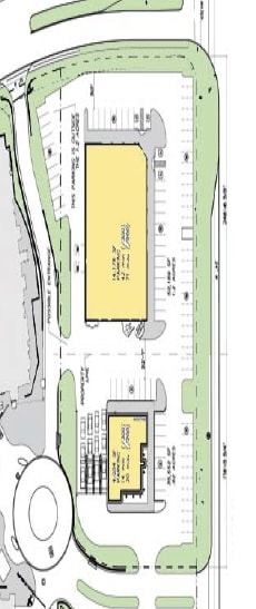
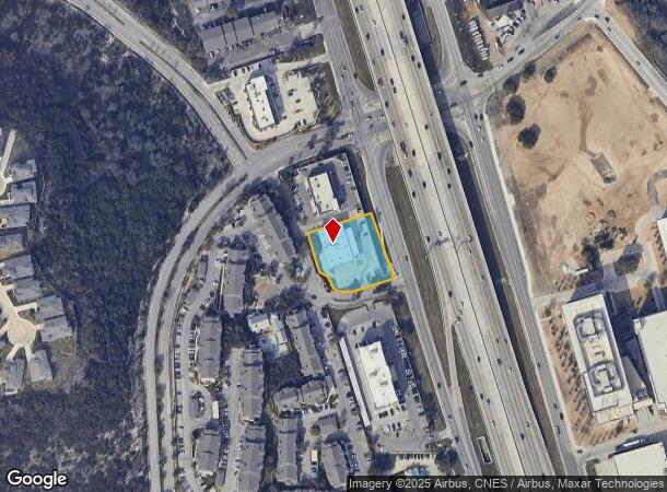
Property Detail
19727 W Interstate 10
San Antonio-New Braunfels, TX
Ncb 18333 (Home & Patio X)
18333-004-0060
NCB 18333 (HOME & PATIO X), BLOCK 4 LOT 6 2017-NEW ACCT CREATED PER PLAT 9706/200-203 FILED 10-7-16. LR/GIS/11-2-16.
Storebuilding
Bexar
X
Texas
48029C0230G
6
2024
0.97 AC
2025
Far Northwest
191807
San Antonio
11,880 SF
DEMOGRAPHICS near 19727 W Interstate 10
1 Mile
3 Mile
5 Mile
2024 Total Population
5,175
31,973
113,825
2029 Population
5,620
34,701
122,019
Pop Growth 2024-2029
+ 8.60%
+ 8.53%
+ 7.20%
Average Age
36
36
36
2024 Total Households
2,704
14,436
45,222
HH Growth 2024-2029
+ 8.76%
+ 8.71%
+ 7.54%
Median Household Inc
$77,461
$80,415
$87,239
Avg Household Size
1.90
2.20
2.40
2024 Avg HH Vehicles
2.00
2.00
2.00
Median Home Value
$540,351
$481,694
$363,871
Median Year Built
2011
2010
2006
Nearby Places
Map Layers
Map Styles
 Street
 Aerial
- Restaurants
- Banks
- Shops
- Fitness
- Groceries
PUBLIC TRANSPORTATION
AIRPORT
San Antonio International
DRIVE
WALK
Distance
San Antonio International
20 min
14.7 mi
Freight Ports
Calhoun Port
DRIVE
WALK
Distance
Calhoun Port
198 min
166.2 mi
Nearby Properties
Address
Land Use
TOTAL SIZE
Lot Size
Zoning
Address
Land Use
TOTAL SIZE
Lot Size
Zoning
23,242.10 AC
Address
Land Use
TOTAL SIZE
Lot Size
Zoning
437,060 SF
91.31 AC
Address
Land Use
TOTAL SIZE
Lot Size
Zoning
405,133 SF
16.41 AC
Address
Land Use
TOTAL SIZE
Lot Size
Zoning
538,895 SF
54.58 AC
Address
Land Use
TOTAL SIZE
Lot Size
Zoning
335,841 SF
33.70 AC
Address
Land Use
TOTAL SIZE
Lot Size
Zoning
538,895 SF
60.25 AC
Address
Land Use
TOTAL SIZE
Lot Size
Zoning
509,312 SF
43.63 AC
Address
Land Use
TOTAL SIZE
Lot Size
Zoning
384,503 SF
15.95 AC
Address
Land Use
TOTAL SIZE
Lot Size
Zoning
391,367 SF
11.36 AC
Address
Land Use
TOTAL SIZE
Lot Size
Zoning
940,089 SF
63.74 AC
Address
Land Use
TOTAL SIZE
Lot Size
Zoning
21,348 SF
14.50 AC
Address
Land Use
TOTAL SIZE
Lot Size
Zoning
13,128 SF
5.23 AC
Address
Land Use
TOTAL SIZE
Lot Size
Zoning
300,264 SF
27.81 AC
Address
Land Use
TOTAL SIZE
Lot Size
Zoning
21,852 SF
5.25 AC
Address
Land Use
TOTAL SIZE
Lot Size
Zoning
481,373 SF
44.28 AC
Address
Land Use
TOTAL SIZE
Lot Size
Zoning
10,622 SF
8.01 AC
Address
Land Use
TOTAL SIZE
Lot Size
Zoning
375,702 SF
10 AC
Address
Land Use
TOTAL SIZE
Lot Size
Zoning
329,050 SF
17.10 AC
Address
Land Use
TOTAL SIZE
Lot Size
Zoning
515,812 SF
200.45 AC
Address
Land Use
TOTAL SIZE
Lot Size
Zoning
305,497 SF
9.99 AC
Address
Land Use
TOTAL SIZE
Lot Size
Zoning
6,809 SF
9.04 AC
Address
Land Use
TOTAL SIZE
Lot Size
Zoning
238,999 SF
8.43 AC
Address
Land Use
TOTAL SIZE
Lot Size
Zoning
329,035 SF
21.28 AC
Address
Land Use
TOTAL SIZE
Lot Size
Zoning
309,429 SF
5.17 AC
Address
Land Use
TOTAL SIZE
Lot Size
Zoning
331,741 SF
16.53 AC
Address
Land Use
TOTAL SIZE
Lot Size
Zoning
244,260 SF
5.82 AC
Address
Land Use
TOTAL SIZE
Lot Size
Zoning
312,150 SF
22.60 AC
Address
Land Use
TOTAL SIZE
Lot Size
Zoning
260,620 SF
10.21 AC
Address
Land Use
TOTAL SIZE
Lot Size
Zoning
277,720 SF
16.97 AC
Address
Land Use
TOTAL SIZE
Lot Size
Zoning
272,094 SF
16.90 AC
The World's #1 Commercial Real Estate Marketplace
Connect with us
© 2025 CoStar Group
The information above has been obtained from sources believed reliable. While we do not doubt its accuracy we have not verified it and make no guarantee, warranty or representation about it. It is your responsibility to independently confirm its accuracy and completeness. Any projections, opinions, assumptions, or estimates used are for example only and do not represent the current or future performance of the property. The value of this transaction to you depends on tax and other factors which should be evaluated by your tax, financial, and legal advisors. You and your advisors should conduct a careful, independent investigation of the property to determine to your satisfaction the suitability of the property for your needs.