Property Record
19730 Fm 362 Rd, Waller, TX 77484
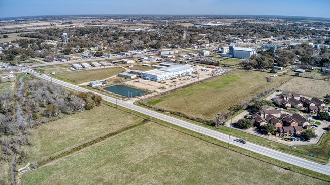

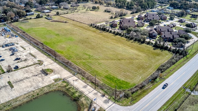

Property Detail
19730 Fm 362 Rd
Houston-Pasadena-The Woodlands, TX
ABS A313900 A-139 H E HEDGEPETH TRACT 3-3 ACRES 7.62
249445
WALLER
Vacantlandnec
Texas
B and X Area of moderate flood hazard, usually the area between the limits of the 100-year and 500-year floods.
7.62 AC
2024
Northwest Outlier
2025
Houston
680301
NEARBY LISTINGS FOR SALE OR LEASE
DEMOGRAPHICS near 19730 Fm 362 Rd
1 mile
3 mile
5 mile
2025 Total Population
2,366
6,503
10,984
2030 Population
2,601
7,188
12,045
Pop Growth 2025-2030
+ 9.93%
+ 10.53%
+ 9.66%
Average Age
37
38
38
2025 Total Households
860
2,335
3,917
HH Growth 2025-2030
+ 9.88%
+ 10.41%
+ 9.57%
Median Household Inc
$39,692
$48,796
$48,087
Avg Household Size
2.80
2.80
2.80
2025 Avg HH Vehicles
2.00
2.00
2.00
Median Home Value
$169,696
$233,567
$261,491
Median Year Built
1981
1991
1993
Nearby Places
Map Layers
Map Styles
 Street
 Aerial
Layers
 Traffic
 Biking
Places
Listings with unknown addresses are not visible on the map
- Restaurants
- Banks
- Shops
- Fitness
- Groceries
SALE & LEASE HISTORY
LISTING DATE
SALE/LEASE

Jan 26, 2024
For Sale
Aug 21, 2017
For Sale
Apr 13, 2021
For Sale
Nearby Properties
Address
Land Use
TOTAL SIZE
Lot Size
Zoning
Address
Land Use
TOTAL SIZE
Lot Size
Zoning
512,325 SF
63.88 AC
Address
Land Use
TOTAL SIZE
Lot Size
Zoning
496,333 SF
86.70 AC
Address
Land Use
TOTAL SIZE
Lot Size
Zoning
189,034 SF
9.49 AC
Address
Land Use
TOTAL SIZE
Lot Size
Zoning
239,994 SF
71.50 AC
Address
Land Use
TOTAL SIZE
Lot Size
Zoning
162,668 SF
39.99 AC
Address
Land Use
TOTAL SIZE
Lot Size
Zoning
123,444 SF
23.37 AC
Address
Land Use
TOTAL SIZE
Lot Size
Zoning
114,480 SF
49.86 AC
Address
Land Use
TOTAL SIZE
Lot Size
Zoning
68,500 SF
16.73 AC
Address
Land Use
TOTAL SIZE
Lot Size
Zoning
62,388 SF
16.54 AC
Address
Land Use
TOTAL SIZE
Lot Size
Zoning
77,880 SF
20 AC
Address
Land Use
TOTAL SIZE
Lot Size
Zoning
121,600 SF
10.06 AC
Address
Land Use
TOTAL SIZE
Lot Size
Zoning
111,160 SF
40 AC
Address
Land Use
TOTAL SIZE
Lot Size
Zoning
123,852 SF
7.80 AC
Address
Land Use
TOTAL SIZE
Lot Size
Zoning
96,437 SF
12.86 AC
Address
Land Use
TOTAL SIZE
Lot Size
Zoning
97,294 SF
14.51 AC
Address
Land Use
TOTAL SIZE
Lot Size
Zoning
146,248 SF
14.62 AC
Address
Land Use
TOTAL SIZE
Lot Size
Zoning
8,167 SF
19.47 AC
Address
Land Use
TOTAL SIZE
Lot Size
Zoning
76,920 SF
16 AC
Address
Land Use
TOTAL SIZE
Lot Size
Zoning
66,520 SF
10.15 AC
Address
Land Use
TOTAL SIZE
Lot Size
Zoning
Address
Land Use
TOTAL SIZE
Lot Size
Zoning
30,748 SF
17.20 AC
Address
Land Use
TOTAL SIZE
Lot Size
Zoning
83,411 SF
9.10 AC
Address
Land Use
TOTAL SIZE
Lot Size
Zoning
94,709 SF
20.91 AC
Address
Land Use
TOTAL SIZE
Lot Size
Zoning
120.20 AC
Address
Land Use
TOTAL SIZE
Lot Size
Zoning
57,880 SF
5.23 AC
Address
Land Use
TOTAL SIZE
Lot Size
Zoning
152.84 AC
Address
Land Use
TOTAL SIZE
Lot Size
Zoning
127.53 AC
Address
Land Use
TOTAL SIZE
Lot Size
Zoning
8,827 SF
8.45 AC
Address
Land Use
TOTAL SIZE
Lot Size
Zoning
44,031 SF
2.40 AC
Address
Land Use
TOTAL SIZE
Lot Size
Zoning
101.59 AC
The World's #1 Commercial Real Estate Marketplace
Connect with us
© 2026 CoStar Group
The information above has been obtained from sources believed reliable. While we do not doubt its accuracy we have not verified it and make no guarantee, warranty or representation about it. It is your responsibility to independently confirm its accuracy and completeness. Any projections, opinions, assumptions, or estimates used are for example only and do not represent the current or future performance of the property. The value of this transaction to you depends on tax and other factors which should be evaluated by your tax, financial, and legal advisors. You and your advisors should conduct a careful, independent investigation of the property to determine to your satisfaction the suitability of the property for your needs.