Property Record
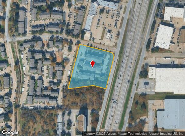
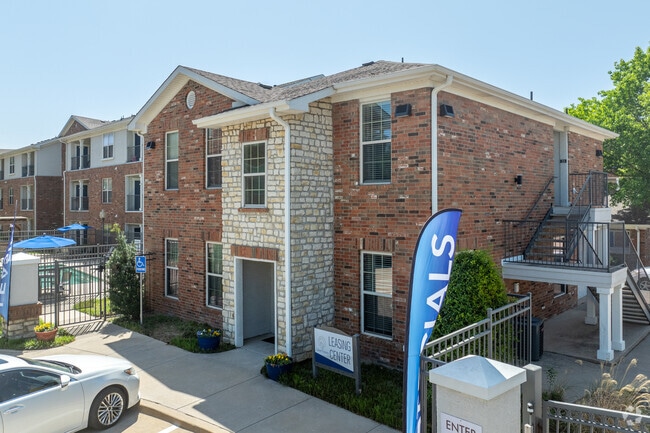
1975 N State Highway 360, Grand Prairie, TX 75050


NEARBY LISTINGS FOR SALE OR LEASE
-
-
View all Grand Prairie listings for sale on LoopNet.com
Property Detail
1975 N State Highway 360
Dallas-Fort Worth-Arlington, TX
Whiteco Residential Addition
40357112
WHITECO RESIDENTIAL ADDN BLOCK 1 LOT 1
Multifamilydwelling
Tarrant
X
Texas
48439C0245L
1
2024
3.95 AC
2025
North Arlington
015405
Dallas/Ft Worth
63,216 SF
DEMOGRAPHICS near 1975 N State Highway 360
1 Mile
3 Mile
5 Mile
2024 Total Population
14,997
79,695
244,243
2029 Population
15,722
83,618
254,424
Pop Growth 2024-2029
+ 4.83%
+ 4.92%
+ 4.17%
Average Age
34
35
35
2024 Total Households
7,276
36,846
94,429
HH Growth 2024-2029
+ 4.93%
+ 5.01%
+ 4.32%
Median Household Inc
$53,536
$56,802
$52,675
Avg Household Size
2.00
2.10
2.50
2024 Avg HH Vehicles
2.00
2.00
2.00
Median Home Value
$316,456
$308,180
$241,806
Median Year Built
1987
1987
1983
Nearby Places
Map Layers
Map Styles
 Street
 Aerial
- Restaurants
- Banks
- Shops
- Fitness
- Groceries
PUBLIC TRANSPORTATION
COMMUTER RAIL
Centre Port/DFW (Trinity Railway Express - Dallas Area Rapid Transit (DART))
DRIVE
WALK
Distance
Centre Port/DFW (Trinity Railway Express - Dallas Area Rapid Transit (DART))
8 min
4.1 mi
DRIVE
WALK
Distance
13 min
5.1 mi
AIRPORT
Dallas-Fort Worth International
DRIVE
WALK
Distance
Dallas-Fort Worth International
17 min
10.3 mi
Dallas Love Field
DRIVE
WALK
Distance
Dallas Love Field
28 min
19.1 mi
Nearby Properties
Address
Land Use
TOTAL SIZE
Lot Size
Zoning
Address
Land Use
TOTAL SIZE
Lot Size
Zoning
1,700,000 SF
8.23 AC
Address
Land Use
TOTAL SIZE
Lot Size
Zoning
3,015,800 SF
72.86 AC
Address
Land Use
TOTAL SIZE
Lot Size
Zoning
1,400,000 SF
15.30 AC
Address
Land Use
TOTAL SIZE
Lot Size
Zoning
378,182 SF
5.02 AC
Address
Land Use
TOTAL SIZE
Lot Size
Zoning
458,819 SF
15.88 AC
Address
Land Use
TOTAL SIZE
Lot Size
Zoning
485,911 SF
54.76 AC
Address
Land Use
TOTAL SIZE
Lot Size
Zoning
521,200 SF
7.99 AC
Address
Land Use
TOTAL SIZE
Lot Size
Zoning
548,095 SF
7.19 AC
Address
Land Use
TOTAL SIZE
Lot Size
Zoning
522,294 SF
18.35 AC
Address
Land Use
TOTAL SIZE
Lot Size
Zoning
578,395 SF
6.22 AC
Address
Land Use
TOTAL SIZE
Lot Size
Zoning
1,261,810 SF
80.53 AC
Address
Land Use
TOTAL SIZE
Lot Size
Zoning
294,296 SF
12.08 AC
Address
Land Use
TOTAL SIZE
Lot Size
Zoning
324,303 SF
23.15 AC
Address
Land Use
TOTAL SIZE
Lot Size
Zoning
450,535 SF
27.23 AC
Address
Land Use
TOTAL SIZE
Lot Size
Zoning
139,821 SF
Address
Land Use
TOTAL SIZE
Lot Size
Zoning
342,583 SF
23.87 AC
Address
Land Use
TOTAL SIZE
Lot Size
Zoning
339,965 SF
15.59 AC
Address
Land Use
TOTAL SIZE
Lot Size
Zoning
358,350 SF
13.15 AC
Address
Land Use
TOTAL SIZE
Lot Size
Zoning
576,000 SF
55.36 AC
Z123
Address
Land Use
TOTAL SIZE
Lot Size
Zoning
539,000 SF
3.91 AC
Address
Land Use
TOTAL SIZE
Lot Size
Zoning
300,915 SF
24.90 AC
Address
Land Use
TOTAL SIZE
Lot Size
Zoning
285,194 SF
15.91 AC
Address
Land Use
TOTAL SIZE
Lot Size
Zoning
313,349 SF
15.39 AC
Address
Land Use
TOTAL SIZE
Lot Size
Zoning
520,000 SF
28.92 AC
Z123
Address
Land Use
TOTAL SIZE
Lot Size
Zoning
345,216 SF
21.64 AC
Address
Land Use
TOTAL SIZE
Lot Size
Zoning
137,878 SF
189.88 AC
Address
Land Use
TOTAL SIZE
Lot Size
Zoning
334,660 SF
17.59 AC
Address
Land Use
TOTAL SIZE
Lot Size
Zoning
253,710 SF
11.50 AC
Address
Land Use
TOTAL SIZE
Lot Size
Zoning
500,256 SF
25.64 AC
Z123
Address
Land Use
TOTAL SIZE
Lot Size
Zoning
267,684 SF
11.01 AC
The World's #1 Commercial Real Estate Marketplace
Connect with us
© 2025 CoStar Group
The information above has been obtained from sources believed reliable. While we do not doubt its accuracy we have not verified it and make no guarantee, warranty or representation about it. It is your responsibility to independently confirm its accuracy and completeness. Any projections, opinions, assumptions, or estimates used are for example only and do not represent the current or future performance of the property. The value of this transaction to you depends on tax and other factors which should be evaluated by your tax, financial, and legal advisors. You and your advisors should conduct a careful, independent investigation of the property to determine to your satisfaction the suitability of the property for your needs.