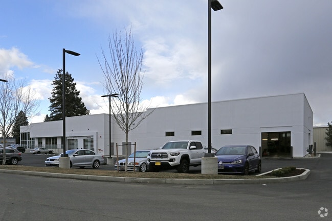
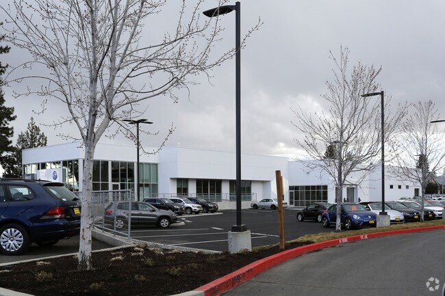
Property Record
1975 Ne Highway 20, Bend, OR 97701

NEARBY LISTINGS FOR SALE OR LEASE
Property Detail
1975 Ne Highway 20
118952
SEC 34 - COM AT SW COR OF NE 1/4 SW 1/4 SD PT ALSO BEING NW COR OF HEALY MEADOWS TH S 89 50 25 E 43...
Commercialnec
Deschutes
X
Oregon
41017C0670E
2.34 AC
2025
Deschutes County
2025
Portland
001802
Bend, OR
14,639 SF
DEMOGRAPHICS near 1975 Ne Highway 20
1 Mile
3 Mile
5 Mile
2024 Total Population
12,432
69,620
110,471
2029 Population
13,788
77,573
123,246
Pop Growth 2024-2029
+ 10.91%
+ 11.42%
+ 11.56%
Average Age
40
40
41
2024 Total Households
5,604
29,173
45,159
HH Growth 2024-2029
+ 11.03%
+ 11.55%
+ 11.71%
Median Household Inc
$59,492
$77,986
$85,733
Avg Household Size
2.10
2.30
2.40
2024 Avg HH Vehicles
2.00
2.00
2.00
Median Home Value
$418,421
$524,079
$635,380
Median Year Built
1996
1997
2000
Nearby Places
Map Layers
Map Styles
 Street
 Aerial
- Restaurants
- Banks
- Shops
- Fitness
- Groceries
PUBLIC TRANSPORTATION
AIRPORT
Roberts Field
DRIVE
WALK
Distance
Roberts Field
28 min
18.2 mi
Freight Ports
Port of Portland
DRIVE
WALK
Distance
Port of Portland
236 min
179.4 mi
Nearby Properties
Address
Land Use
TOTAL SIZE
Lot Size
Zoning
Address
Land Use
TOTAL SIZE
Lot Size
Zoning
35.14 AC
RH
Address
Land Use
TOTAL SIZE
Lot Size
Zoning
61,869 SF
35.14 AC
RH
Address
Land Use
TOTAL SIZE
Lot Size
Zoning
35.14 AC
RH
Address
Land Use
TOTAL SIZE
Lot Size
Zoning
10,490 SF
35.14 AC
RH
Address
Land Use
TOTAL SIZE
Lot Size
Zoning
116,476 SF
35.14 AC
RH
Address
Land Use
TOTAL SIZE
Lot Size
Zoning
35.14 AC
RH
Address
Land Use
TOTAL SIZE
Lot Size
Zoning
35.14 AC
Address
Land Use
TOTAL SIZE
Lot Size
Zoning
144,000 SF
35.14 AC
RH
Address
Land Use
TOTAL SIZE
Lot Size
Zoning
35.14 AC
RH
Address
Land Use
TOTAL SIZE
Lot Size
Zoning
35.14 AC
RH
Address
Land Use
TOTAL SIZE
Lot Size
Zoning
11,947 SF
35.14 AC
RH
Address
Land Use
TOTAL SIZE
Lot Size
Zoning
35.14 AC
Address
Land Use
TOTAL SIZE
Lot Size
Zoning
35.14 AC
Address
Land Use
TOTAL SIZE
Lot Size
Zoning
35.14 AC
RH
Address
Land Use
TOTAL SIZE
Lot Size
Zoning
144,000 SF
35.14 AC
RH
Address
Land Use
TOTAL SIZE
Lot Size
Zoning
144,000 SF
35.14 AC
RH
Address
Land Use
TOTAL SIZE
Lot Size
Zoning
35.14 AC
RH
Address
Land Use
TOTAL SIZE
Lot Size
Zoning
12,000 SF
2.77 AC
IL
Address
Land Use
TOTAL SIZE
Lot Size
Zoning
2.77 AC
IL
Address
Land Use
TOTAL SIZE
Lot Size
Zoning
3.74 AC
MR
Address
Land Use
TOTAL SIZE
Lot Size
Zoning
25,574 SF
3.74 AC
MR
Address
Land Use
TOTAL SIZE
Lot Size
Zoning
27,863 SF
4.23 AC
MU
Address
Land Use
TOTAL SIZE
Lot Size
Zoning
201,150 SF
3.75 AC
RH
Address
Land Use
TOTAL SIZE
Lot Size
Zoning
166,371 SF
2.52 AC
MU
Address
Land Use
TOTAL SIZE
Lot Size
Zoning
199,892 SF
19.16 AC
CG
Address
Land Use
TOTAL SIZE
Lot Size
Zoning
115,973 SF
73.55 AC
UA
Address
Land Use
TOTAL SIZE
Lot Size
Zoning
1,546 SF
6.41 AC
RH
Address
Land Use
TOTAL SIZE
Lot Size
Zoning
1.04 AC
CB
Address
Land Use
TOTAL SIZE
Lot Size
Zoning
201,575 SF
1.04 AC
CB
Address
Land Use
TOTAL SIZE
Lot Size
Zoning
165,048 SF
4.68 AC
RM
The World's #1 Commercial Real Estate Marketplace
Connect with us
© 2026 CoStar Group
The information above has been obtained from sources believed reliable. While we do not doubt its accuracy we have not verified it and make no guarantee, warranty or representation about it. It is your responsibility to independently confirm its accuracy and completeness. Any projections, opinions, assumptions, or estimates used are for example only and do not represent the current or future performance of the property. The value of this transaction to you depends on tax and other factors which should be evaluated by your tax, financial, and legal advisors. You and your advisors should conduct a careful, independent investigation of the property to determine to your satisfaction the suitability of the property for your needs.