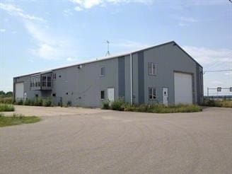
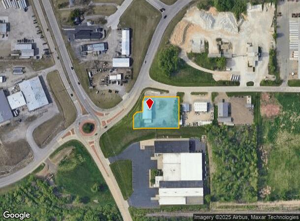
Property Record
1975 Stillman Dr, Oshkosh, WI 54901
NEARBY LISTINGS FOR SALE OR LEASE
Property Detail
1975 Stillman Dr
Oshkosh-Neenah, WI
Certified Surv Map 1987
018-011408
PT SW SE DESC AS LOT 1 OF CSM-6363 .96 A.
Commercialnec
Winnebago
X
Wisconsin
55139C0215E
1
2024
0.96 AC
2024
Appleton/Oshkosh
001700
Other Market Areas
DEMOGRAPHICS near 1975 Stillman Dr
1 Mile
3 Mile
5 Mile
2024 Total Population
1,390
47,090
75,797
2029 Population
1,388
47,312
76,090
Pop Growth 2024-2029
(0.14%)
+ 0.47%
+ 0.39%
Average Age
41
39
39
2024 Total Households
600
18,943
31,311
HH Growth 2024-2029
(0.33%)
+ 0.94%
+ 0.61%
Median Household Inc
$68,898
$55,280
$59,903
Avg Household Size
2.30
2.10
2.20
2024 Avg HH Vehicles
2.00
2.00
2.00
Median Home Value
$167,192
$171,179
$172,873
Median Year Built
1984
1975
1972
Nearby Places
Map Layers
Map Styles
 Street
 Aerial
- Restaurants
- Banks
- Shops
- Fitness
- Groceries
PUBLIC TRANSPORTATION
AIRPORT
Appleton International
DRIVE
WALK
Distance
Appleton International
25 min
18.6 mi
Freight Ports
Port Milwaukee
DRIVE
WALK
Distance
Port Milwaukee
107 min
91.2 mi
SALE & LEASE HISTORY
LISTING DATE
SALE/LEASE

Sep 08, 2017
For Lease
Jan 25, 2023
For Lease
Nearby Properties
Address
Land Use
TOTAL SIZE
Lot Size
Zoning
Address
Land Use
TOTAL SIZE
Lot Size
Zoning
32.81 AC
CBPPD
Address
Land Use
TOTAL SIZE
Lot Size
Zoning
195,810 SF
31.08 AC
MR-20
Address
Land Use
TOTAL SIZE
Lot Size
Zoning
208,278 SF
22.77 AC
C2
Address
Land Use
TOTAL SIZE
Lot Size
Zoning
255,080 SF
21.29 AC
MR-12
Address
Land Use
TOTAL SIZE
Lot Size
Zoning
552,602 SF
7.28 AC
M3
Address
Land Use
TOTAL SIZE
Lot Size
Zoning
485,007 SF
41.76 AC
M3
Address
Land Use
TOTAL SIZE
Lot Size
Zoning
14.77 AC
SMU-PD
Address
Land Use
TOTAL SIZE
Lot Size
Zoning
2.29 AC
RMUPDRFO
Address
Land Use
TOTAL SIZE
Lot Size
Zoning
140,184 SF
17.35 AC
MR-20-PD
Address
Land Use
TOTAL SIZE
Lot Size
Zoning
70,672 SF
4.97 AC
Address
Land Use
TOTAL SIZE
Lot Size
Zoning
161,640 SF
18.54 AC
C-2PD
Address
Land Use
TOTAL SIZE
Lot Size
Zoning
70,335 SF
16 AC
HI
Address
Land Use
TOTAL SIZE
Lot Size
Zoning
2.40 AC
CBP-PD
Address
Land Use
TOTAL SIZE
Lot Size
Zoning
152,505 SF
6.54 AC
MR-20-RFO
Address
Land Use
TOTAL SIZE
Lot Size
Zoning
84,363 SF
10.97 AC
C-2PD
Address
Land Use
TOTAL SIZE
Lot Size
Zoning
53,998 SF
3.63 AC
C2
Address
Land Use
TOTAL SIZE
Lot Size
Zoning
175,906 SF
11.60 AC
MR-20
Address
Land Use
TOTAL SIZE
Lot Size
Zoning
1.78 AC
C3
Address
Land Use
TOTAL SIZE
Lot Size
Zoning
25,456 SF
1.74 AC
R1;SINGLE
Address
Land Use
TOTAL SIZE
Lot Size
Zoning
80,118 SF
7.88 AC
C2
Address
Land Use
TOTAL SIZE
Lot Size
Zoning
34,340 SF
8.56 AC
C2
Address
Land Use
TOTAL SIZE
Lot Size
Zoning
140,296 SF
13.58 AC
C-2
Address
Land Use
TOTAL SIZE
Lot Size
Zoning
4.76 AC
C2
Address
Land Use
TOTAL SIZE
Lot Size
Zoning
106,340 SF
5.37 AC
MR-20
Address
Land Use
TOTAL SIZE
Lot Size
Zoning
366,482 SF
35.73 AC
M2
Address
Land Use
TOTAL SIZE
Lot Size
Zoning
4.52 AC
SMU-PD
Address
Land Use
TOTAL SIZE
Lot Size
Zoning
1.81 AC
SMU
Address
Land Use
TOTAL SIZE
Lot Size
Zoning
100,361 SF
14.25 AC
SMU-PD
Address
Land Use
TOTAL SIZE
Lot Size
Zoning
96,928 SF
6.94 AC
MR-12
Address
Land Use
TOTAL SIZE
Lot Size
Zoning
100,912 SF
5.50 AC
MR-20
The World's #1 Commercial Real Estate Marketplace
Connect with us
© 2025 CoStar Group
The information above has been obtained from sources believed reliable. While we do not doubt its accuracy we have not verified it and make no guarantee, warranty or representation about it. It is your responsibility to independently confirm its accuracy and completeness. Any projections, opinions, assumptions, or estimates used are for example only and do not represent the current or future performance of the property. The value of this transaction to you depends on tax and other factors which should be evaluated by your tax, financial, and legal advisors. You and your advisors should conduct a careful, independent investigation of the property to determine to your satisfaction the suitability of the property for your needs.