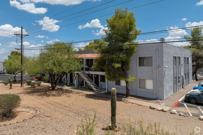
Property Record
1975 W 36Th St, Tucson, AZ 85713

NEARBY LISTINGS FOR SALE OR LEASE
Property Detail
1975 W 36Th St
Tucson, AZ
Enchanted Hills Blk B
119-22-1840
ENCHANTED HILLS BLK B
Apartment
Pima
X
Arizona
04019C2260L
9
2025
3.02 AC
2026
Enchanted Hills
004407
Tucson
67,008 SF
DEMOGRAPHICS near 1975 W 36Th St
1 Mile
3 Mile
5 Mile
2024 Total Population
8,852
68,494
199,369
2029 Population
9,160
71,164
206,189
Pop Growth 2024-2029
+ 3.48%
+ 3.90%
+ 3.42%
Average Age
36
37
37
2024 Total Households
3,240
27,165
77,168
HH Growth 2024-2029
+ 3.49%
+ 4.06%
+ 3.57%
Median Household Inc
$43,007
$46,141
$45,585
Avg Household Size
2.60
2.40
2.40
2024 Avg HH Vehicles
2.00
2.00
2.00
Median Home Value
$170,547
$177,688
$181,030
Median Year Built
1982
1981
1979
Nearby Places
Map Layers
Map Styles
 Street
 Aerial
- Restaurants
- Banks
- Shops
- Fitness
- Groceries
PUBLIC TRANSPORTATION
COMMUTER RAIL
Tucson Amtrak Station (Sunset Limited - Amtrak, Texas Eagle - Amtrak)
DRIVE
WALK
Distance
Tucson Amtrak Station (Sunset Limited - Amtrak, Texas Eagle - Amtrak)
9 min
4.4 mi
AIRPORT
Tucson International
DRIVE
WALK
Distance
Tucson International
18 min
9.4 mi
Freight Ports
Port of San Diego
DRIVE
WALK
Distance
Port of San Diego
438 min
411.4 mi
Nearby Properties
Address
Land Use
TOTAL SIZE
Lot Size
Zoning
Address
Land Use
TOTAL SIZE
Lot Size
Zoning
819,879 SF
44.77 AC
SP
Address
Land Use
TOTAL SIZE
Lot Size
Zoning
813,186 SF
3.65 AC
OCR2
Address
Land Use
TOTAL SIZE
Lot Size
Zoning
89,497 SF
0.51 AC
Address
Land Use
TOTAL SIZE
Lot Size
Zoning
657,188 SF
24.97 AC
PAD5
Address
Land Use
TOTAL SIZE
Lot Size
Zoning
866,763 SF
17.17 AC
O3
Address
Land Use
TOTAL SIZE
Lot Size
Zoning
239,060 SF
7.85 AC
Address
Land Use
TOTAL SIZE
Lot Size
Zoning
475,707 SF
107.59 AC
Address
Land Use
TOTAL SIZE
Lot Size
Zoning
652,898 SF
233.08 AC
RX2
Address
Land Use
TOTAL SIZE
Lot Size
Zoning
377,470 SF
17.48 AC
R1
Address
Land Use
TOTAL SIZE
Lot Size
Zoning
418,519 SF
2.36 AC
OCR2
Address
Land Use
TOTAL SIZE
Lot Size
Zoning
298,003 SF
0.73 AC
Address
Land Use
TOTAL SIZE
Lot Size
Zoning
222,699 SF
2.22 AC
Address
Land Use
TOTAL SIZE
Lot Size
Zoning
42,880 SF
4.27 AC
I1
Address
Land Use
TOTAL SIZE
Lot Size
Zoning
213,066 SF
0.91 AC
OCR2
Address
Land Use
TOTAL SIZE
Lot Size
Zoning
103,230 SF
15.64 AC
C3
Address
Land Use
TOTAL SIZE
Lot Size
Zoning
183,261 SF
0.82 AC
C3
Address
Land Use
TOTAL SIZE
Lot Size
Zoning
355,555 SF
38.97 AC
R2
Address
Land Use
TOTAL SIZE
Lot Size
Zoning
248,388 SF
20.45 AC
O3
Address
Land Use
TOTAL SIZE
Lot Size
Zoning
185,564 SF
8.50 AC
Address
Land Use
TOTAL SIZE
Lot Size
Zoning
119,759 SF
3.49 AC
C3
Address
Land Use
TOTAL SIZE
Lot Size
Zoning
7,300 SF
1.60 AC
C3
Address
Land Use
TOTAL SIZE
Lot Size
Zoning
291,038 SF
16.42 AC
C1
Address
Land Use
TOTAL SIZE
Lot Size
Zoning
214,907 SF
12.03 AC
C1
Address
Land Use
TOTAL SIZE
Lot Size
Zoning
157,834 SF
16.26 AC
C2
Address
Land Use
TOTAL SIZE
Lot Size
Zoning
51,203 SF
4.48 AC
Address
Land Use
TOTAL SIZE
Lot Size
Zoning
129,500 SF
6.43 AC
Address
Land Use
TOTAL SIZE
Lot Size
Zoning
91,085 SF
2.07 AC
Address
Land Use
TOTAL SIZE
Lot Size
Zoning
11.79 AC
Address
Land Use
TOTAL SIZE
Lot Size
Zoning
79,546 SF
6.54 AC
Address
Land Use
TOTAL SIZE
Lot Size
Zoning
74,952 SF
5.01 AC
PAD4
The World's #1 Commercial Real Estate Marketplace
Connect with us
© 2026 CoStar Group
The information above has been obtained from sources believed reliable. While we do not doubt its accuracy we have not verified it and make no guarantee, warranty or representation about it. It is your responsibility to independently confirm its accuracy and completeness. Any projections, opinions, assumptions, or estimates used are for example only and do not represent the current or future performance of the property. The value of this transaction to you depends on tax and other factors which should be evaluated by your tax, financial, and legal advisors. You and your advisors should conduct a careful, independent investigation of the property to determine to your satisfaction the suitability of the property for your needs.