Property Record
1978 Highway 52, Chatsworth, GA 30705
NEARBY LISTINGS FOR SALE OR LEASE
-
-
View all Chatsworth listings for sale on LoopNet.com
Property Detail
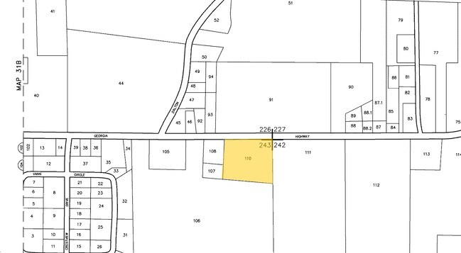
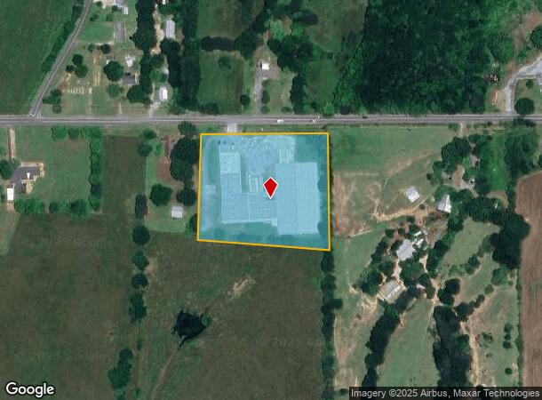
1978 Highway 52
0049A-110
County Industrial
Warehouse
ALT 52 HWY
X
Murray
13213C0120D
Georgia
2024
4.34 AC
2024
Georgia Northwest
010402
Other Market Areas
68,988 SF
Dalton, GA
DEMOGRAPHICS near 1978 Highway 52
1 Mile
3 Mile
5 Mile
2024 Total Population
2,233
14,235
24,664
2029 Population
2,297
14,697
25,353
Pop Growth 2024-2029
+ 2.87%
+ 3.25%
+ 2.79%
Average Age
38
39
39
2024 Total Households
855
5,269
9,050
HH Growth 2024-2029
+ 2.92%
+ 3.21%
+ 2.75%
Median Household Inc
$51,279
$53,724
$54,228
Avg Household Size
2.60
2.60
2.70
2024 Avg HH Vehicles
2.00
2.00
2.00
Median Home Value
$146,963
$161,287
$163,933
Median Year Built
1991
1990
1989
Nearby Places
Map Layers
Map Styles
 Street
 Aerial
- Restaurants
- Banks
- Shops
- Fitness
- Groceries
PUBLIC TRANSPORTATION
AIRPORT
Lovell Field
DRIVE
WALK
Distance
Lovell Field
52 min
38.7 mi
Freight Ports
Georgia Ports - Savannah
DRIVE
WALK
Distance
Georgia Ports - Savannah
388 min
338.0 mi
Nearby Properties
Address
Land Use
TOTAL SIZE
Lot Size
Zoning
Address
Land Use
TOTAL SIZE
Lot Size
Zoning
94,027 SF
27.94 AC
SR
Address
Land Use
TOTAL SIZE
Lot Size
Zoning
60,758 SF
36 AC
CH
Address
Land Use
TOTAL SIZE
Lot Size
Zoning
773,250 SF
60.79 AC
CH
Address
Land Use
TOTAL SIZE
Lot Size
Zoning
8,770 SF
9.21 AC
CH
Address
Land Use
TOTAL SIZE
Lot Size
Zoning
81,777 SF
22.34 AC
CH
Address
Land Use
TOTAL SIZE
Lot Size
Zoning
904,772 SF
100.72 AC
CH
Address
Land Use
TOTAL SIZE
Lot Size
Zoning
1,500 SF
15.28 AC
CH
Address
Land Use
TOTAL SIZE
Lot Size
Zoning
136,000 SF
31.84 AC
IND
Address
Land Use
TOTAL SIZE
Lot Size
Zoning
2,030 SF
6.43 AC
CH
Address
Land Use
TOTAL SIZE
Lot Size
Zoning
57,272 SF
7.62 AC
CH
Address
Land Use
TOTAL SIZE
Lot Size
Zoning
65,804 SF
18.63 AC
CH
Address
Land Use
TOTAL SIZE
Lot Size
Zoning
95,320 SF
13.30 AC
IND
Address
Land Use
TOTAL SIZE
Lot Size
Zoning
17,850 SF
3.50 AC
CH
Address
Land Use
TOTAL SIZE
Lot Size
Zoning
1,496 SF
34.02 AC
CH
Address
Land Use
TOTAL SIZE
Lot Size
Zoning
33,000 SF
6.74 AC
CH
Address
Land Use
TOTAL SIZE
Lot Size
Zoning
30,662 SF
20.76 AC
SR
Address
Land Use
TOTAL SIZE
Lot Size
Zoning
253,760 SF
53.22 AC
CH
Address
Land Use
TOTAL SIZE
Lot Size
Zoning
233,557 SF
10.53 AC
CH
Address
Land Use
TOTAL SIZE
Lot Size
Zoning
24,130 SF
17.92 AC
SR
Address
Land Use
TOTAL SIZE
Lot Size
Zoning
5,040 SF
2.70 AC
MFR
Address
Land Use
TOTAL SIZE
Lot Size
Zoning
2,000 SF
24.85 AC
CH
Address
Land Use
TOTAL SIZE
Lot Size
Zoning
243,701 SF
37.05 AC
CH
Address
Land Use
TOTAL SIZE
Lot Size
Zoning
13,300 SF
1.01 AC
CH
Address
Land Use
TOTAL SIZE
Lot Size
Zoning
14,480 SF
2.05 AC
CH
Address
Land Use
TOTAL SIZE
Lot Size
Zoning
37,276 SF
5.10 AC
CH
Address
Land Use
TOTAL SIZE
Lot Size
Zoning
190,935 SF
39.63 AC
CH
Address
Land Use
TOTAL SIZE
Lot Size
Zoning
12,408 SF
1.84 AC
CH
Address
Land Use
TOTAL SIZE
Lot Size
Zoning
135,000 SF
7.50 AC
CH
Address
Land Use
TOTAL SIZE
Lot Size
Zoning
2,744 SF
8.20 AC
SR
Address
Land Use
TOTAL SIZE
Lot Size
Zoning
12,420 SF
6.28 AC
CH
The World's #1 Commercial Real Estate Marketplace
Connect with us
© 2026 CoStar Group
The information above has been obtained from sources believed reliable. While we do not doubt its accuracy we have not verified it and make no guarantee, warranty or representation about it. It is your responsibility to independently confirm its accuracy and completeness. Any projections, opinions, assumptions, or estimates used are for example only and do not represent the current or future performance of the property. The value of this transaction to you depends on tax and other factors which should be evaluated by your tax, financial, and legal advisors. You and your advisors should conduct a careful, independent investigation of the property to determine to your satisfaction the suitability of the property for your needs.