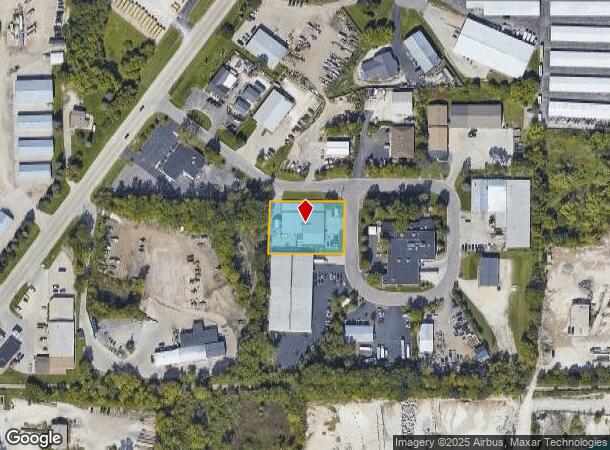
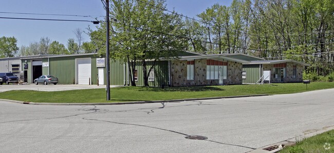
Property Record
19785 W Edgewood Dr, Lannon, WI 53046

NEARBY LISTINGS FOR SALE OR LEASE
Property Detail
19785 W Edgewood Dr
Milwaukee-Waukesha-West Allis, WI
PT NE1/4 SW1/4 SEC 17 T8N R20E; COM CTR SEC 17 S0010E 1292.87 FT; S8838W 768.73 FT; N0028E 341.00 FT THE BGN; N0028E 150.00 FT; N8838E 210.00 FT; S0122E 149.00 FT; S8823W 214.80 FT TO BGN :: DOC# 4103540
LANV-0067-999-003
Waukesha
Commercialnec
Wisconsin
X
8
55133C0093H
0.74 AC
2024
NE/Menomonee Falls
2024
Milwaukee/Madison
200300
DEMOGRAPHICS near 19785 W Edgewood Dr
1 Mile
3 Mile
5 Mile
2024 Total Population
2,062
23,692
72,311
2029 Population
2,075
23,878
72,980
Pop Growth 2024-2029
+ 0.63%
+ 0.79%
+ 0.93%
Average Age
42
45
43
2024 Total Households
826
10,017
28,978
HH Growth 2024-2029
+ 0.48%
+ 0.74%
+ 0.77%
Median Household Inc
$81,359
$86,536
$101,481
Avg Household Size
2.50
2.30
2.50
2024 Avg HH Vehicles
2.00
2.00
2.00
Median Home Value
$295,999
$292,485
$331,280
Median Year Built
1992
1977
1983
Nearby Places
Map Layers
Map Styles
 Street
 Aerial
- Restaurants
- Banks
- Shops
- Fitness
- Groceries
PUBLIC TRANSPORTATION
AIRPORT
General Mitchell International
DRIVE
WALK
Distance
General Mitchell International
43 min
26.7 mi
Freight Ports
Port Milwaukee
DRIVE
WALK
Distance
Port Milwaukee
38 min
22.9 mi
Nearby Properties
Address
Land Use
TOTAL SIZE
Lot Size
Zoning
Address
Land Use
TOTAL SIZE
Lot Size
Zoning
244,996 SF
16.82 AC
Address
Land Use
TOTAL SIZE
Lot Size
Zoning
145,836 SF
11 AC
Address
Land Use
TOTAL SIZE
Lot Size
Zoning
294,486 SF
12.78 AC
Address
Land Use
TOTAL SIZE
Lot Size
Zoning
864,365 SF
50.22 AC
Address
Land Use
TOTAL SIZE
Lot Size
Zoning
74.81 AC
Address
Land Use
TOTAL SIZE
Lot Size
Zoning
145,844 SF
27.98 AC
Address
Land Use
TOTAL SIZE
Lot Size
Zoning
358,699 SF
24.97 AC
Address
Land Use
TOTAL SIZE
Lot Size
Zoning
24.03 AC
Address
Land Use
TOTAL SIZE
Lot Size
Zoning
204,175 SF
2.48 AC
Address
Land Use
TOTAL SIZE
Lot Size
Zoning
104,642 SF
7.06 AC
Address
Land Use
TOTAL SIZE
Lot Size
Zoning
302,895 SF
7.90 AC
Address
Land Use
TOTAL SIZE
Lot Size
Zoning
245,615 SF
15.88 AC
Address
Land Use
TOTAL SIZE
Lot Size
Zoning
12.64 AC
Address
Land Use
TOTAL SIZE
Lot Size
Zoning
152,006 SF
12.92 AC
Address
Land Use
TOTAL SIZE
Lot Size
Zoning
14.12 AC
Address
Land Use
TOTAL SIZE
Lot Size
Zoning
34.36 AC
Address
Land Use
TOTAL SIZE
Lot Size
Zoning
90,077 SF
0.95 AC
Address
Land Use
TOTAL SIZE
Lot Size
Zoning
Address
Land Use
TOTAL SIZE
Lot Size
Zoning
112,642 SF
10.73 AC
Address
Land Use
TOTAL SIZE
Lot Size
Zoning
106,514 SF
8.12 AC
Address
Land Use
TOTAL SIZE
Lot Size
Zoning
117,834 SF
10.80 AC
Address
Land Use
TOTAL SIZE
Lot Size
Zoning
85,193 SF
3.71 AC
Address
Land Use
TOTAL SIZE
Lot Size
Zoning
18.03 AC
Address
Land Use
TOTAL SIZE
Lot Size
Zoning
95,367 SF
5.42 AC
Address
Land Use
TOTAL SIZE
Lot Size
Zoning
31,144 SF
26.95 AC
Address
Land Use
TOTAL SIZE
Lot Size
Zoning
94,963 SF
13.30 AC
Address
Land Use
TOTAL SIZE
Lot Size
Zoning
63,850 SF
7.25 AC
Address
Land Use
TOTAL SIZE
Lot Size
Zoning
10.17 AC
Address
Land Use
TOTAL SIZE
Lot Size
Zoning
Address
Land Use
TOTAL SIZE
Lot Size
Zoning
67,777 SF
20.22 AC
The World's #1 Commercial Real Estate Marketplace
Connect with us
© 2025 CoStar Group
The information above has been obtained from sources believed reliable. While we do not doubt its accuracy we have not verified it and make no guarantee, warranty or representation about it. It is your responsibility to independently confirm its accuracy and completeness. Any projections, opinions, assumptions, or estimates used are for example only and do not represent the current or future performance of the property. The value of this transaction to you depends on tax and other factors which should be evaluated by your tax, financial, and legal advisors. You and your advisors should conduct a careful, independent investigation of the property to determine to your satisfaction the suitability of the property for your needs.