Property Record
1979 2Nd Ave, Greeley, CO 80631
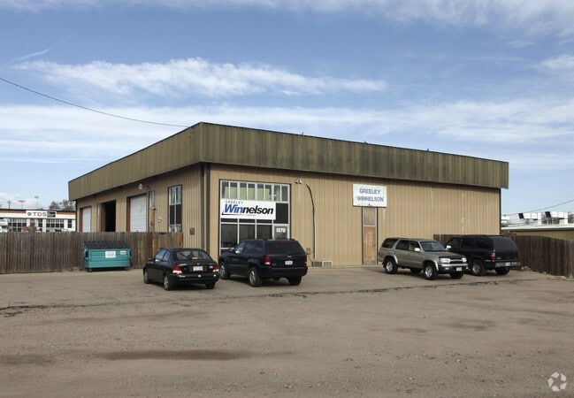


Property Detail
1979 2Nd Ave
R0165490
GR 12224 PT L6-7 SE4SE4 ALSO PT L5 OF SW4SE4 8 5 65 W OF US #85 BY-PASS EXC N230 OF L5 & 6 LYING BETWEEN UPRR & US HWY #85 BY PASS ALSO EXC BEG N89D30W 735.40 FROM SE COR SE4 THENCE N0D15W 214.99 N89D30W 202.61 S0D15E 215.02 THENCE S89D30E 202.61 TO
Warehouse
Weld
B and X Area of moderate flood hazard, usually the area between the limits of the 100-year and 500-year floods.
Colorado
2024
1 AC
2025
Weld County
000701
Denver
12,200 SF
Greeley, CO
NEARBY LISTINGS FOR SALE OR LEASE
DEMOGRAPHICS near 1979 2Nd Ave
1 mile
3 mile
5 mile
2025 Total Population
21,917
83,860
136,085
2030 Population
24,918
92,463
149,866
Pop Growth 2025-2030
+ 13.69%
+ 10.26%
+ 10.13%
Average Age
31
35
36
2025 Total Households
7,479
29,477
48,481
HH Growth 2025-2030
+ 15.43%
+ 11.11%
+ 10.78%
Median Household Inc
$47,450
$54,781
$63,576
Avg Household Size
2.60
2.60
2.70
2025 Avg HH Vehicles
2.00
2.00
2.00
Median Home Value
$296,628
$340,995
$360,750
Median Year Built
1993
1976
1986
Nearby Places
Map Layers
Map Styles
 Street
 Aerial
Transit
 Traffic
 Biking
Places
Listings with unknown addresses are not visible on the map
- Restaurants
- Banks
- Shops
- Fitness
- Groceries
Nearby Properties
Address
Land Use
TOTAL SIZE
Lot Size
Zoning
Address
Land Use
TOTAL SIZE
Lot Size
Zoning
1,682,342 SF
134.62 AC
Address
Land Use
TOTAL SIZE
Lot Size
Zoning
1,181,203 SF
23.26 AC
Address
Land Use
TOTAL SIZE
Lot Size
Zoning
689,580 SF
65.15 AC
Address
Land Use
TOTAL SIZE
Lot Size
Zoning
280,000 SF
43.91 AC
Address
Land Use
TOTAL SIZE
Lot Size
Zoning
536,281 SF
33.91 AC
Address
Land Use
TOTAL SIZE
Lot Size
Zoning
237,575 SF
10.77 AC
Address
Land Use
TOTAL SIZE
Lot Size
Zoning
113,715 SF
9.42 AC
Address
Land Use
TOTAL SIZE
Lot Size
Zoning
78.18 AC
Address
Land Use
TOTAL SIZE
Lot Size
Zoning
83,032 SF
9.23 AC
Address
Land Use
TOTAL SIZE
Lot Size
Zoning
150,693 SF
20 AC
Address
Land Use
TOTAL SIZE
Lot Size
Zoning
34,697 SF
55.28 AC
Address
Land Use
TOTAL SIZE
Lot Size
Zoning
700,277 SF
16.35 AC
Address
Land Use
TOTAL SIZE
Lot Size
Zoning
219,178 SF
22.28 AC
Address
Land Use
TOTAL SIZE
Lot Size
Zoning
309,821 SF
13.55 AC
Address
Land Use
TOTAL SIZE
Lot Size
Zoning
122,023 SF
12.29 AC
Address
Land Use
TOTAL SIZE
Lot Size
Zoning
63,960 SF
3.67 AC
Address
Land Use
TOTAL SIZE
Lot Size
Zoning
202,130 SF
25.35 AC
Address
Land Use
TOTAL SIZE
Lot Size
Zoning
239,925 SF
6.06 AC
Address
Land Use
TOTAL SIZE
Lot Size
Zoning
127,822 SF
1.38 AC
Address
Land Use
TOTAL SIZE
Lot Size
Zoning
132,968 SF
1.24 AC
Address
Land Use
TOTAL SIZE
Lot Size
Zoning
82,759 SF
2.05 AC
Address
Land Use
TOTAL SIZE
Lot Size
Zoning
145,184 SF
19 AC
Address
Land Use
TOTAL SIZE
Lot Size
Zoning
198,845 SF
16.02 AC
Address
Land Use
TOTAL SIZE
Lot Size
Zoning
88,620 SF
5.11 AC
Address
Land Use
TOTAL SIZE
Lot Size
Zoning
128,054 SF
Address
Land Use
TOTAL SIZE
Lot Size
Zoning
178,873 SF
4.13 AC
Address
Land Use
TOTAL SIZE
Lot Size
Zoning
114,879 SF
27.73 AC
Address
Land Use
TOTAL SIZE
Lot Size
Zoning
52,041 SF
4.36 AC
Address
Land Use
TOTAL SIZE
Lot Size
Zoning
144,758 SF
18.99 AC
Address
Land Use
TOTAL SIZE
Lot Size
Zoning
72,400 SF
19.55 AC
The World's #1 Commercial Real Estate Marketplace
Connect with us
© 2026 CoStar Group
The information above has been obtained from sources believed reliable. While we do not doubt its accuracy we have not verified it and make no guarantee, warranty or representation about it. It is your responsibility to independently confirm its accuracy and completeness. Any projections, opinions, assumptions, or estimates used are for example only and do not represent the current or future performance of the property. The value of this transaction to you depends on tax and other factors which should be evaluated by your tax, financial, and legal advisors. You and your advisors should conduct a careful, independent investigation of the property to determine to your satisfaction the suitability of the property for your needs.