Property Record
19792 El Rivino Rd, Bloomington, CA 92316
Current Lease Availabilities
NEARBY LISTINGS FOR SALE OR LEASE
Property Detail
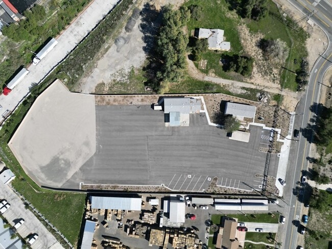
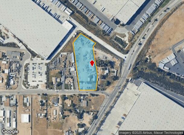
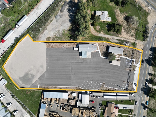
19792 El Rivino Rd
Riverside-San Bernardino-Ontario, CA
Rivino Orchards
0260-051-14
A PORTION OF LOT 20 OF TRACT NO. 2501 AS FILED IN BOOK 36 OF MAPS, PAGES 28 AND 29, RECORDS OF THE COUNTY OF SAN BERNARDINO, STATE OF CALIFORNIA, MORE PARTICULARLY DESCRIBED AS FOLLOWS: BEGINNING AT THE SOUTHWEST CORNER OF SAID LOT 20, SAID POINT BEI
Slaughterhousestockyard
San Bernardino
X
California
06065C0065H
20
2024
2.72 AC
2025
San Bernardino
004001
Inland Empire (California)
704 SF
DEMOGRAPHICS near 19792 El Rivino Rd
1 Mile
3 Mile
5 Mile
2024 Total Population
660
46,753
293,563
2029 Population
674
48,341
302,284
Pop Growth 2024-2029
+ 2.12%
+ 3.40%
+ 2.97%
Average Age
35
35
35
2024 Total Households
146
11,924
82,133
HH Growth 2024-2029
+ 2.05%
+ 3.30%
+ 2.91%
Median Household Inc
$70,356
$73,562
$69,058
Avg Household Size
4.00
3.70
3.40
2024 Avg HH Vehicles
2.00
3.00
2.00
Median Home Value
$517,857
$403,335
$397,594
Median Year Built
1968
1974
1975
Nearby Places
- Restaurants
- Banks
- Shops
- Fitness
- Groceries
PUBLIC TRANSPORTATION
COMMUTER RAIL
Riverside-Hunter Park/Ucr (Metrolink 91-Perris Valley Line - Metrolink Trains)
DRIVE
WALK
Distance
Riverside-Hunter Park/Ucr (Metrolink 91-Perris Valley Line - Metrolink Trains)
7 min
4.7 mi
Riverside-Downtown (91 Line - Southern California Regional Rail Authority (Metrolink), Inland Empire-Orange County Line - Southern California Regional Rail Authority (Metrolink), Riverside Line - Southern California Regional Rail Authority (Metrolink))
DRIVE
WALK
Distance
Riverside-Downtown (91 Line - Southern California Regional Rail Authority (Metrolink), Inland Empire-Orange County Line - Southern California Regional Rail Authority (Metrolink), Riverside Line - Southern California Regional Rail Authority (Metrolink))
10 min
5.3 mi
AIRPORT
Ontario International
DRIVE
WALK
Distance
Ontario International
22 min
16.6 mi
Freight Ports
Port of Long Beach
DRIVE
WALK
Distance
Port of Long Beach
79 min
61.3 mi
Nearby Properties
Address
Land Use
TOTAL SIZE
Lot Size
Zoning
Address
Land Use
TOTAL SIZE
Lot Size
Zoning
1,186,950 SF
54.77 AC
Address
Land Use
TOTAL SIZE
Lot Size
Zoning
1,025,132 SF
46.44 AC
Address
Land Use
TOTAL SIZE
Lot Size
Zoning
1,264,064 SF
64.44 AC
Address
Land Use
TOTAL SIZE
Lot Size
Zoning
1,000,177 SF
46 AC
Address
Land Use
TOTAL SIZE
Lot Size
Zoning
798,304 SF
42.64 AC
AMSP
Address
Land Use
TOTAL SIZE
Lot Size
Zoning
505,152 SF
28.88 AC
Address
Land Use
TOTAL SIZE
Lot Size
Zoning
677,280 SF
34.53 AC
BLRS1AA
Address
Land Use
TOTAL SIZE
Lot Size
Zoning
615,310 SF
49.91 AC
Address
Land Use
TOTAL SIZE
Lot Size
Zoning
344,360 SF
17.32 AC
Address
Land Use
TOTAL SIZE
Lot Size
Zoning
599,735 SF
33.25 AC
AMSP
Address
Land Use
TOTAL SIZE
Lot Size
Zoning
311,363 SF
34.60 AC
BLRS20M
Address
Land Use
TOTAL SIZE
Lot Size
Zoning
411,707 SF
19.34 AC
Address
Land Use
TOTAL SIZE
Lot Size
Zoning
401,106 SF
16.91 AC
Address
Land Use
TOTAL SIZE
Lot Size
Zoning
340,120 SF
36.36 AC
Address
Land Use
TOTAL SIZE
Lot Size
Zoning
272,120 SF
13.05 AC
Address
Land Use
TOTAL SIZE
Lot Size
Zoning
525,110 SF
24.25 AC
Address
Land Use
TOTAL SIZE
Lot Size
Zoning
492,631 SF
21 AC
Address
Land Use
TOTAL SIZE
Lot Size
Zoning
35,260 SF
9.55 AC
Address
Land Use
TOTAL SIZE
Lot Size
Zoning
447,190 SF
21.08 AC
Address
Land Use
TOTAL SIZE
Lot Size
Zoning
182,624 SF
16.07 AC
Address
Land Use
TOTAL SIZE
Lot Size
Zoning
424,904 SF
23.03 AC
Address
Land Use
TOTAL SIZE
Lot Size
Zoning
261,632 SF
13.16 AC
Address
Land Use
TOTAL SIZE
Lot Size
Zoning
208,510 SF
47.30 AC
BLIC
Address
Land Use
TOTAL SIZE
Lot Size
Zoning
1,056,072 SF
51.85 AC
AMSP
Address
Land Use
TOTAL SIZE
Lot Size
Zoning
55.22 AC
AMSP
Address
Land Use
TOTAL SIZE
Lot Size
Zoning
72,860 SF
7.71 AC
Address
Land Use
TOTAL SIZE
Lot Size
Zoning
750,700 SF
32.81 AC
AMSP
Address
Land Use
TOTAL SIZE
Lot Size
Zoning
47,809 SF
11.73 AC
Address
Land Use
TOTAL SIZE
Lot Size
Zoning
210,004 SF
11.68 AC
Address
Land Use
TOTAL SIZE
Lot Size
Zoning
12,372 SF
9.07 AC
BLRS20M
The World's #1 Commercial Real Estate Marketplace
Connect with us
© 2025 CoStar Group
The information above has been obtained from sources believed reliable. While we do not doubt its accuracy we have not verified it and make no guarantee, warranty or representation about it. It is your responsibility to independently confirm its accuracy and completeness. Any projections, opinions, assumptions, or estimates used are for example only and do not represent the current or future performance of the property. The value of this transaction to you depends on tax and other factors which should be evaluated by your tax, financial, and legal advisors. You and your advisors should conduct a careful, independent investigation of the property to determine to your satisfaction the suitability of the property for your needs.