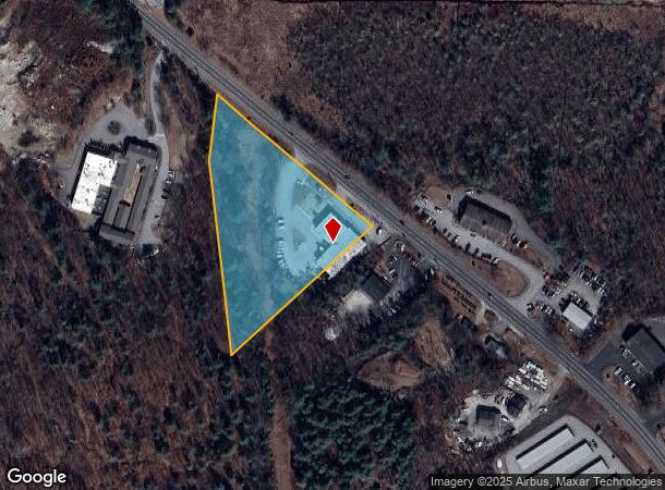
Property Record
198 Londonderry Tpke, Hooksett, NH 03106
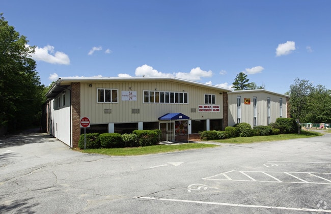
This Property Is For Sale
Current Lease Availabilities
NEARBY LISTINGS FOR SALE OR LEASE
Property Detail
198 Londonderry Tpke
HOOK-000036-000045-000001
Merrimack
Commercialbuilding
New Hampshire
X
1
33013C0691E
3.41 AC
2024
Manchester/New Hampshire South Area
2024
Other Market Areas
003006
Concord, NH
18,240 SF
DEMOGRAPHICS near 198 Londonderry Tpke
1 Mile
3 Mile
5 Mile
2024 Total Population
3,458
28,086
105,666
2029 Population
3,655
29,035
107,761
Pop Growth 2024-2029
+ 5.70%
+ 3.38%
+ 1.98%
Average Age
40
42
40
2024 Total Households
1,198
11,330
44,491
HH Growth 2024-2029
+ 5.68%
+ 3.35%
+ 2.02%
Median Household Inc
$135,630
$98,959
$74,125
Avg Household Size
2.70
2.40
2.20
2024 Avg HH Vehicles
2.00
2.00
2.00
Median Home Value
$384,679
$358,286
$327,712
Median Year Built
1987
1982
1968
Nearby Places
Map Layers
Map Styles
 Street
 Aerial
- Restaurants
- Banks
- Shops
- Fitness
- Groceries
PUBLIC TRANSPORTATION
AIRPORT
Manchester Boston Regional
DRIVE
WALK
Distance
Manchester Boston Regional
23 min
11.3 mi
Portsmouth International at Pease
DRIVE
WALK
Distance
Portsmouth International at Pease
59 min
40.0 mi
Freight Ports
Port of Boston
DRIVE
WALK
Distance
Port of Boston
85 min
55.3 mi
Nearby Properties
Address
Land Use
TOTAL SIZE
Lot Size
Zoning
Address
Land Use
TOTAL SIZE
Lot Size
Zoning
12.60 AC
PZ
Address
Land Use
TOTAL SIZE
Lot Size
Zoning
6,830 SF
17.24 AC
Address
Land Use
TOTAL SIZE
Lot Size
Zoning
135,686 SF
30.23 AC
Address
Land Use
TOTAL SIZE
Lot Size
Zoning
36,070 SF
141.66 AC
MUD4
Address
Land Use
TOTAL SIZE
Lot Size
Zoning
24,064 SF
19.44 AC
Address
Land Use
TOTAL SIZE
Lot Size
Zoning
51.32 AC
MUD4
Address
Land Use
TOTAL SIZE
Lot Size
Zoning
211,525 SF
93.01 AC
Address
Land Use
TOTAL SIZE
Lot Size
Zoning
154,363 SF
17.25 AC
MUD3
Address
Land Use
TOTAL SIZE
Lot Size
Zoning
1,998 SF
72.09 AC
MDR
Address
Land Use
TOTAL SIZE
Lot Size
Zoning
44,301 SF
71.24 AC
Address
Land Use
TOTAL SIZE
Lot Size
Zoning
Address
Land Use
TOTAL SIZE
Lot Size
Zoning
28,888 SF
5.50 AC
Address
Land Use
TOTAL SIZE
Lot Size
Zoning
82,670 SF
27.76 AC
PZ
Address
Land Use
TOTAL SIZE
Lot Size
Zoning
5,150 SF
13.50 AC
Address
Land Use
TOTAL SIZE
Lot Size
Zoning
69,339 SF
39.63 AC
IND
Address
Land Use
TOTAL SIZE
Lot Size
Zoning
96,192 SF
17.42 AC
IND
Address
Land Use
TOTAL SIZE
Lot Size
Zoning
95,626 SF
19.51 AC
MUD3
Address
Land Use
TOTAL SIZE
Lot Size
Zoning
40,718 SF
3.42 AC
Address
Land Use
TOTAL SIZE
Lot Size
Zoning
85,656 SF
13.56 AC
MUD3
Address
Land Use
TOTAL SIZE
Lot Size
Zoning
3,608 SF
133.83 AC
Address
Land Use
TOTAL SIZE
Lot Size
Zoning
119,910 SF
15.07 AC
MUD3
Address
Land Use
TOTAL SIZE
Lot Size
Zoning
1,976 SF
40.02 AC
Address
Land Use
TOTAL SIZE
Lot Size
Zoning
35,478 SF
4.50 AC
Address
Land Use
TOTAL SIZE
Lot Size
Zoning
156,344 SF
19.90 AC
IND
Address
Land Use
TOTAL SIZE
Lot Size
Zoning
76,600 SF
18.76 AC
MUD3
Address
Land Use
TOTAL SIZE
Lot Size
Zoning
57,964 SF
13.85 AC
PZ
Address
Land Use
TOTAL SIZE
Lot Size
Zoning
144,966 SF
13.26 AC
PZ
Address
Land Use
TOTAL SIZE
Lot Size
Zoning
1,704 SF
76.35 AC
Address
Land Use
TOTAL SIZE
Lot Size
Zoning
58.87 AC
R9
Address
Land Use
TOTAL SIZE
Lot Size
Zoning
43,494 SF
9.60 AC
The World's #1 Commercial Real Estate Marketplace
Connect with us
© 2025 CoStar Group
The information above has been obtained from sources believed reliable. While we do not doubt its accuracy we have not verified it and make no guarantee, warranty or representation about it. It is your responsibility to independently confirm its accuracy and completeness. Any projections, opinions, assumptions, or estimates used are for example only and do not represent the current or future performance of the property. The value of this transaction to you depends on tax and other factors which should be evaluated by your tax, financial, and legal advisors. You and your advisors should conduct a careful, independent investigation of the property to determine to your satisfaction the suitability of the property for your needs.