Property Record
198 N Myrtle Ave, Elmhurst, IL 60126

NEARBY LISTINGS FOR SALE OR LEASE
-
-
View all Elmhurst listings for sale on LoopNet.com
Property Detail
198 N Myrtle Ave
Whitewater-Elkhorn, WI
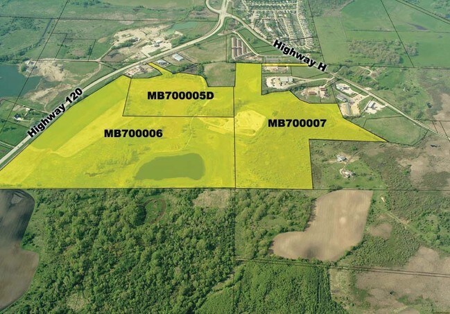
Certified Survey Map No 4033
MB700005D
NW1/4 SE1/4 & SW1/4 NE1/4 SEC 7 T1N R18E DESC AS COM AT S 1/4 COR SD SEC 7; N01D09'06"W ALG W LN SD 1/4 SEC 2640' TO CTR OF SD SEC; N88D28'50"E ALG N LN SD 1/4 SEC 42.81' TO POB; N88D28'50"E ALG SD N LN 366.14' TO NW COR CSM 2961; ALG W LN SD CSM & W
Agriculturalland
Walworth
X
Wisconsin
55127C0345E
2.03 AC
2024
Walworth East
2024
Milwaukee/Madison
001504
DEMOGRAPHICS near 198 N Myrtle Ave
1 Mile
3 Mile
5 Mile
2024 Total Population
950
10,301
18,250
2029 Population
889
10,503
18,517
Pop Growth 2024-2029
(6.42%)
+ 1.96%
+ 1.46%
Average Age
40
41
42
2024 Total Households
360
4,331
7,670
HH Growth 2024-2029
(6.94%)
+ 1.82%
+ 1.30%
Median Household Inc
$59,106
$62,692
$69,509
Avg Household Size
2.70
2.30
2.30
2024 Avg HH Vehicles
2.00
2.00
2.00
Median Home Value
$132,031
$227,733
$250,488
Median Year Built
1992
1983
1974
Nearby Places
Map Layers
Map Styles
 Street
 Aerial
- Restaurants
- Banks
- Shops
- Fitness
- Groceries
Nearby Properties
Address
Land Use
TOTAL SIZE
Lot Size
Zoning
Address
Land Use
TOTAL SIZE
Lot Size
Zoning
Address
Land Use
TOTAL SIZE
Lot Size
Zoning
21.36 AC
Address
Land Use
TOTAL SIZE
Lot Size
Zoning
11.50 AC
Address
Land Use
TOTAL SIZE
Lot Size
Zoning
7.85 AC
Address
Land Use
TOTAL SIZE
Lot Size
Zoning
1.72 AC
B3
Address
Land Use
TOTAL SIZE
Lot Size
Zoning
15.88 AC
Address
Land Use
TOTAL SIZE
Lot Size
Zoning
10.61 AC
Address
Land Use
TOTAL SIZE
Lot Size
Zoning
Address
Land Use
TOTAL SIZE
Lot Size
Zoning
4.62 AC
Address
Land Use
TOTAL SIZE
Lot Size
Zoning
111 AC
R1
Address
Land Use
TOTAL SIZE
Lot Size
Zoning
2.87 AC
Address
Land Use
TOTAL SIZE
Lot Size
Zoning
Address
Land Use
TOTAL SIZE
Lot Size
Zoning
4.70 AC
Address
Land Use
TOTAL SIZE
Lot Size
Zoning
Address
Land Use
TOTAL SIZE
Lot Size
Zoning
6.02 AC
Address
Land Use
TOTAL SIZE
Lot Size
Zoning
Address
Land Use
TOTAL SIZE
Lot Size
Zoning
3.02 AC
Address
Land Use
TOTAL SIZE
Lot Size
Zoning
Address
Land Use
TOTAL SIZE
Lot Size
Zoning
Address
Land Use
TOTAL SIZE
Lot Size
Zoning
Address
Land Use
TOTAL SIZE
Lot Size
Zoning
0.83 AC
R1
Address
Land Use
TOTAL SIZE
Lot Size
Zoning
0.66 AC
R4
Address
Land Use
TOTAL SIZE
Lot Size
Zoning
5.36 AC
Address
Land Use
TOTAL SIZE
Lot Size
Zoning
4.45 AC
Address
Land Use
TOTAL SIZE
Lot Size
Zoning
3.92 AC
Address
Land Use
TOTAL SIZE
Lot Size
Zoning
Address
Land Use
TOTAL SIZE
Lot Size
Zoning
Address
Land Use
TOTAL SIZE
Lot Size
Zoning
Address
Land Use
TOTAL SIZE
Lot Size
Zoning
Address
Land Use
TOTAL SIZE
Lot Size
Zoning
The World's #1 Commercial Real Estate Marketplace
Connect with us
© 2025 CoStar Group
The information above has been obtained from sources believed reliable. While we do not doubt its accuracy we have not verified it and make no guarantee, warranty or representation about it. It is your responsibility to independently confirm its accuracy and completeness. Any projections, opinions, assumptions, or estimates used are for example only and do not represent the current or future performance of the property. The value of this transaction to you depends on tax and other factors which should be evaluated by your tax, financial, and legal advisors. You and your advisors should conduct a careful, independent investigation of the property to determine to your satisfaction the suitability of the property for your needs.