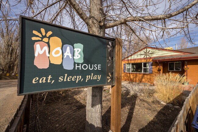
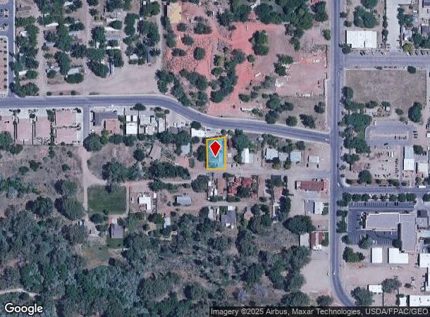
Property Record
198 W Center St, Moab, UT 84532

NEARBY LISTINGS FOR SALE OR LEASE
-
-
View all Moab listings for sale on LoopNet.com
Property Detail
198 W Center St
Realpropertynec
BEG AT COR WHICH BEARS W 695.8 FT & N 533.3 FT FROM C1/4 SEC 1 T26S R21E SLB&M & PROC W 76 FT; N 103'W 127.1 FT; N 8225'E 60.
X
Grand
49019C1758D
Utah
2025
0.23 AC
2025
Moab
000200
Other Market Areas
1,699 SF
01-0001-0146
DEMOGRAPHICS near 198 W Center St
1 Mile
3 Mile
5 Mile
2024 Total Population
4,518
6,573
8,384
2029 Population
4,624
6,687
8,566
Pop Growth 2024-2029
+ 2.35%
+ 1.73%
+ 2.17%
Average Age
40
40
41
2024 Total Households
1,865
2,724
3,492
HH Growth 2024-2029
+ 2.41%
+ 1.87%
+ 2.32%
Median Household Inc
$43,909
$49,858
$53,292
Avg Household Size
2.40
2.40
2.40
2024 Avg HH Vehicles
2.00
2.00
2.00
Median Home Value
$429,166
$439,519
$463,390
Median Year Built
1976
1976
1980
Nearby Places
Map Layers
Map Styles
 Street
 Aerial
- Restaurants
- Banks
- Shops
- Fitness
- Groceries
SALE & LEASE HISTORY
LISTING DATE
SALE/LEASE

Mar 19, 2024
For Sale
Nearby Properties
Address
Land Use
TOTAL SIZE
Lot Size
Zoning
Address
Land Use
TOTAL SIZE
Lot Size
Zoning
5.23 AC
Address
Land Use
TOTAL SIZE
Lot Size
Zoning
33.88 AC
Address
Land Use
TOTAL SIZE
Lot Size
Zoning
62,319 SF
4.85 AC
Address
Land Use
TOTAL SIZE
Lot Size
Zoning
68,110 SF
1.38 AC
Address
Land Use
TOTAL SIZE
Lot Size
Zoning
78,548 SF
1.26 AC
Address
Land Use
TOTAL SIZE
Lot Size
Zoning
8,500 SF
21.32 AC
Address
Land Use
TOTAL SIZE
Lot Size
Zoning
59,086 SF
2.65 AC
Address
Land Use
TOTAL SIZE
Lot Size
Zoning
59,032 SF
5 AC
Address
Land Use
TOTAL SIZE
Lot Size
Zoning
1,391 SF
9.40 AC
Address
Land Use
TOTAL SIZE
Lot Size
Zoning
5,875 SF
2.25 AC
Address
Land Use
TOTAL SIZE
Lot Size
Zoning
2,205 SF
39.56 AC
Address
Land Use
TOTAL SIZE
Lot Size
Zoning
51,795 SF
1.26 AC
Address
Land Use
TOTAL SIZE
Lot Size
Zoning
58,355 SF
2.58 AC
Address
Land Use
TOTAL SIZE
Lot Size
Zoning
72,946 SF
3.34 AC
Address
Land Use
TOTAL SIZE
Lot Size
Zoning
2,863 SF
4.73 AC
Address
Land Use
TOTAL SIZE
Lot Size
Zoning
51,056 SF
3.04 AC
Address
Land Use
TOTAL SIZE
Lot Size
Zoning
57,094 SF
2.44 AC
Address
Land Use
TOTAL SIZE
Lot Size
Zoning
56,316 SF
1.85 AC
Address
Land Use
TOTAL SIZE
Lot Size
Zoning
1,016 SF
2.67 AC
Address
Land Use
TOTAL SIZE
Lot Size
Zoning
546 SF
6.33 AC
Address
Land Use
TOTAL SIZE
Lot Size
Zoning
0.63 AC
Address
Land Use
TOTAL SIZE
Lot Size
Zoning
7.02 AC
Address
Land Use
TOTAL SIZE
Lot Size
Zoning
32,623 SF
1.49 AC
Address
Land Use
TOTAL SIZE
Lot Size
Zoning
51,005 SF
4.58 AC
Address
Land Use
TOTAL SIZE
Lot Size
Zoning
34.06 AC
Address
Land Use
TOTAL SIZE
Lot Size
Zoning
24,593 SF
1.63 AC
Address
Land Use
TOTAL SIZE
Lot Size
Zoning
6,796 SF
1.31 AC
Address
Land Use
TOTAL SIZE
Lot Size
Zoning
0.03 AC
Address
Land Use
TOTAL SIZE
Lot Size
Zoning
44,491 SF
2.59 AC
Address
Land Use
TOTAL SIZE
Lot Size
Zoning
7,338 SF
0.92 AC
The World's #1 Commercial Real Estate Marketplace
Connect with us
© 2025 CoStar Group
The information above has been obtained from sources believed reliable. While we do not doubt its accuracy we have not verified it and make no guarantee, warranty or representation about it. It is your responsibility to independently confirm its accuracy and completeness. Any projections, opinions, assumptions, or estimates used are for example only and do not represent the current or future performance of the property. The value of this transaction to you depends on tax and other factors which should be evaluated by your tax, financial, and legal advisors. You and your advisors should conduct a careful, independent investigation of the property to determine to your satisfaction the suitability of the property for your needs.