Property Record
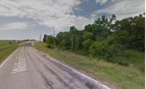
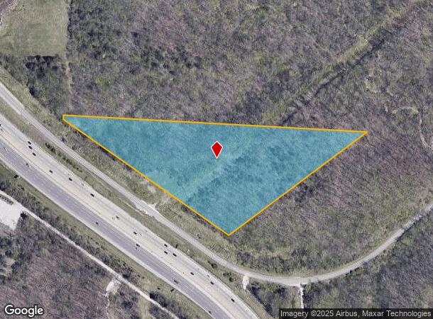
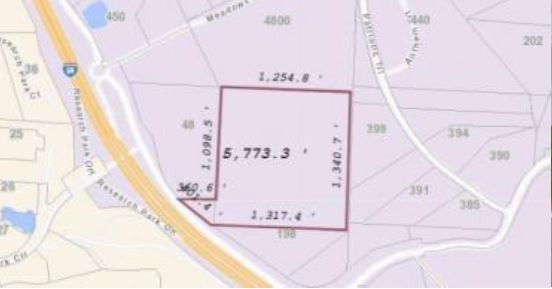
198 Wolfrum Rd, Weldon Spring, MO 63304
NEARBY LISTINGS FOR SALE OR LEASE
Property Detail
198 Wolfrum Rd
St. Louis, MO-IL
Trails Riverwood 03
3-0058-S034-00-0004.0000000
PT SE NE 1/4 E LINE OF HWY
Vacantlandnec
St. Charles
X
Missouri
29183C0435G
4
2024
11.58 AC
2025
St Charles County
311122
St. Louis
DEMOGRAPHICS near 198 Wolfrum Rd
1 mile
3 mile
5 mile
2024 Total Population
613
20,388
81,566
2029 Population
645
21,539
85,556
Pop Growth 2024-2029
+ 5.22%
+ 5.65%
+ 4.89%
Average Age
47
42
40
2024 Total Households
217
7,435
29,180
HH Growth 2024-2029
+ 5.07%
+ 5.76%
+ 5.05%
Median Household Inc
$140,865
$126,274
$121,290
Avg Household Size
2.80
2.70
2.70
2024 Avg HH Vehicles
3.00
2.00
2.00
Median Home Value
$621,154
$343,621
$331,566
Median Year Built
1992
1994
1995
Nearby Places
Map Layers
Map Styles
 Street
 Aerial
Transit
 Traffic
 Biking
Places
Listings with unknown addresses are not visible on the map
- Restaurants
- Banks
- Shops
- Fitness
- Groceries
PUBLIC TRANSPORTATION
AIRPORT
St Louis Lambert International
Drive
Walk
Distance
St Louis Lambert International
33 min
23.0 mi
Freight Ports
Tulsa Port of Inola
Drive
Walk
Distance
Tulsa Port of Inola
415 min
370.8 mi
SALE & LEASE HISTORY
LISTING DATE
SALE/LEASE

May 29, 2019
For Sale
Nearby Properties
Address
Land Use
TOTAL SIZE
Lot Size
Zoning
Address
Land Use
TOTAL SIZE
Lot Size
Zoning
Address
Land Use
TOTAL SIZE
Lot Size
Zoning
351,496 SF
31.73 AC
NU
Address
Land Use
TOTAL SIZE
Lot Size
Zoning
511,592 SF
45.64 AC
Address
Land Use
TOTAL SIZE
Lot Size
Zoning
376,359 SF
16.75 AC
Address
Land Use
TOTAL SIZE
Lot Size
Zoning
361,166 SF
31.01 AC
Address
Land Use
TOTAL SIZE
Lot Size
Zoning
75,360 SF
8.13 AC
Address
Land Use
TOTAL SIZE
Lot Size
Zoning
98,490 SF
7.32 AC
Address
Land Use
TOTAL SIZE
Lot Size
Zoning
117,704 SF
9.27 AC
105PI
Address
Land Use
TOTAL SIZE
Lot Size
Zoning
290,011 SF
23.40 AC
Address
Land Use
TOTAL SIZE
Lot Size
Zoning
294.04 AC
Address
Land Use
TOTAL SIZE
Lot Size
Zoning
202,569 SF
15.58 AC
Address
Land Use
TOTAL SIZE
Lot Size
Zoning
84,818 SF
10.11 AC
105M3
Address
Land Use
TOTAL SIZE
Lot Size
Zoning
351,110 SF
12.90 AC
Address
Land Use
TOTAL SIZE
Lot Size
Zoning
94,879 SF
14.91 AC
Address
Land Use
TOTAL SIZE
Lot Size
Zoning
8.15 AC
105PI
Address
Land Use
TOTAL SIZE
Lot Size
Zoning
146,975 SF
6.98 AC
Address
Land Use
TOTAL SIZE
Lot Size
Zoning
53.02 AC
AA1
Address
Land Use
TOTAL SIZE
Lot Size
Zoning
148,519 SF
12.76 AC
FPM3
Address
Land Use
TOTAL SIZE
Lot Size
Zoning
131,169 SF
8.22 AC
Address
Land Use
TOTAL SIZE
Lot Size
Zoning
147,182 SF
9.27 AC
AF0
Address
Land Use
TOTAL SIZE
Lot Size
Zoning
250,270 SF
14.72 AC
Address
Land Use
TOTAL SIZE
Lot Size
Zoning
161,043 SF
6.99 AC
Address
Land Use
TOTAL SIZE
Lot Size
Zoning
106,400 SF
18.14 AC
Address
Land Use
TOTAL SIZE
Lot Size
Zoning
163,924 SF
11.56 AC
105M3
Address
Land Use
TOTAL SIZE
Lot Size
Zoning
134,313 SF
11.65 AC
105M3
Address
Land Use
TOTAL SIZE
Lot Size
Zoning
78,976 SF
10.24 AC
105M3
Address
Land Use
TOTAL SIZE
Lot Size
Zoning
78,566 SF
6.13 AC
105PI
Address
Land Use
TOTAL SIZE
Lot Size
Zoning
60,655 SF
10.33 AC
FPNU
Address
Land Use
TOTAL SIZE
Lot Size
Zoning
58,733 SF
4 AC
105M3
Address
Land Use
TOTAL SIZE
Lot Size
Zoning
37.04 AC
AF0
The World's #1 Commercial Real Estate Marketplace
Connect with us
© 2026 CoStar Group
The information above has been obtained from sources believed reliable. While we do not doubt its accuracy we have not verified it and make no guarantee, warranty or representation about it. It is your responsibility to independently confirm its accuracy and completeness. Any projections, opinions, assumptions, or estimates used are for example only and do not represent the current or future performance of the property. The value of this transaction to you depends on tax and other factors which should be evaluated by your tax, financial, and legal advisors. You and your advisors should conduct a careful, independent investigation of the property to determine to your satisfaction the suitability of the property for your needs.