Property Record
1980 Crystal Falls Pkwy, Leander, TX 78641
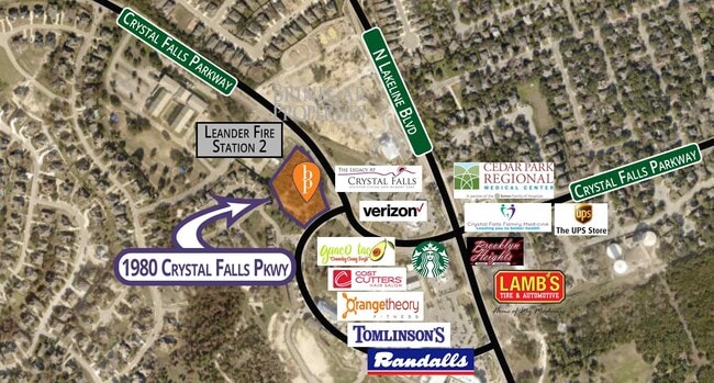

This Property Is For Sale
Property Detail
1980 Crystal Falls Pkwy
Austin-Round Rock-San Marcos, TX
S10907 - CRYSTAL FALLS TOWN CENTER PH 2, BLOCK A, LOT 7, ACRES 2.37, (1.874AC/GWI), PT/GTR
R539133
WILLIAMSON
Commercialacreage
Texas
B and X Area of moderate flood hazard, usually the area between the limits of the 100-year and 500-year floods.
7
2024
2.37 AC
2025
Far Northwest
020337
Austin
NEARBY LISTINGS FOR SALE OR LEASE
-
-
-
-
-
-
-
-
-
-
-
-
-
-
-
-
-
-
NEC W. Whitestone (F.M. 1431) @ Travisso Parkway
Leander, TX 78641
Rent Upon Request
1.79 - 18.27 AC Lot
Land
-
-
-
-
U.S. Hwy 183-A (Toll Road) @ Covewind Bend Blvd
Leander, TX 78641
Rent Upon Request
5.54 AC Lots
Land
-
-
-
View all Leander listings for sale on LoopNet.com
DEMOGRAPHICS near 1980 Crystal Falls Pkwy
1 mile
3 mile
5 mile
2025 Total Population
13,401
80,307
149,062
2030 Population
15,137
91,036
169,363
Pop Growth 2025-2030
+ 12.95%
+ 13.36%
+ 13.62%
Average Age
37
37
37
2025 Total Households
4,478
27,917
52,473
HH Growth 2025-2030
+ 13.53%
+ 13.92%
+ 14.16%
Median Household Inc
$174,740
$126,519
$130,418
Avg Household Size
3.00
2.90
2.80
2025 Avg HH Vehicles
2.00
2.00
2.00
Median Home Value
$613,760
$469,266
$492,769
Median Year Built
2010
2008
2008
Nearby Places
Map Layers
Map Styles
 Street
 Aerial
Transit
 Traffic
 Biking
Places
Listings with unknown addresses are not visible on the map
- Restaurants
- Banks
- Shops
- Fitness
- Groceries
PUBLIC TRANSPORTATION
AIRPORT
Austin-Bergstrom International
Drive
Walk
Distance
Austin-Bergstrom International
51 min
36.3 mi
Freight Ports
Calhoun Port
Drive
Walk
Distance
Calhoun Port
216 min
179.8 mi
Nearby Properties
Address
Land Use
TOTAL SIZE
Lot Size
Zoning
Address
Land Use
TOTAL SIZE
Lot Size
Zoning
341,700 SF
17.71 AC
Address
Land Use
TOTAL SIZE
Lot Size
Zoning
181,000 SF
30.14 AC
Address
Land Use
TOTAL SIZE
Lot Size
Zoning
310,297 SF
15.01 AC
Address
Land Use
TOTAL SIZE
Lot Size
Zoning
325,045 SF
22.75 AC
Address
Land Use
TOTAL SIZE
Lot Size
Zoning
246,060 SF
9.30 AC
Address
Land Use
TOTAL SIZE
Lot Size
Zoning
249,826 SF
37.40 AC
Address
Land Use
TOTAL SIZE
Lot Size
Zoning
238,420 SF
13.72 AC
Address
Land Use
TOTAL SIZE
Lot Size
Zoning
117,076 SF
15.51 AC
Address
Land Use
TOTAL SIZE
Lot Size
Zoning
238,343 SF
12.08 AC
Address
Land Use
TOTAL SIZE
Lot Size
Zoning
234,214 SF
19.63 AC
Address
Land Use
TOTAL SIZE
Lot Size
Zoning
195,426 SF
12.11 AC
Address
Land Use
TOTAL SIZE
Lot Size
Zoning
316,408 SF
15 AC
Address
Land Use
TOTAL SIZE
Lot Size
Zoning
193,011 SF
8.91 AC
Address
Land Use
TOTAL SIZE
Lot Size
Zoning
229,977 SF
16.85 AC
Address
Land Use
TOTAL SIZE
Lot Size
Zoning
94,861 SF
12.72 AC
Address
Land Use
TOTAL SIZE
Lot Size
Zoning
151,181 SF
6 AC
Address
Land Use
TOTAL SIZE
Lot Size
Zoning
191,654 SF
4.57 AC
2-LI
Address
Land Use
TOTAL SIZE
Lot Size
Zoning
240,800 SF
17.16 AC
Address
Land Use
TOTAL SIZE
Lot Size
Zoning
264,140 SF
21.37 AC
Address
Land Use
TOTAL SIZE
Lot Size
Zoning
175,521 SF
14.76 AC
Address
Land Use
TOTAL SIZE
Lot Size
Zoning
193,864 SF
11.22 AC
Address
Land Use
TOTAL SIZE
Lot Size
Zoning
20.47 AC
Address
Land Use
TOTAL SIZE
Lot Size
Zoning
123,858 SF
6.06 AC
Address
Land Use
TOTAL SIZE
Lot Size
Zoning
185,652 SF
10 AC
Address
Land Use
TOTAL SIZE
Lot Size
Zoning
60 AC
1-SFU
Address
Land Use
TOTAL SIZE
Lot Size
Zoning
207,697 SF
26.25 AC
4-GR
Address
Land Use
TOTAL SIZE
Lot Size
Zoning
99,223 SF
8.90 AC
Address
Land Use
TOTAL SIZE
Lot Size
Zoning
34,824 SF
4.53 AC
4-GR
Address
Land Use
TOTAL SIZE
Lot Size
Zoning
197,911 SF
9.74 AC
Address
Land Use
TOTAL SIZE
Lot Size
Zoning
196,228 SF
12.31 AC
The World's #1 Commercial Real Estate Marketplace
Connect with us
© 2026 CoStar Group
The information above has been obtained from sources believed reliable. While we do not doubt its accuracy we have not verified it and make no guarantee, warranty or representation about it. It is your responsibility to independently confirm its accuracy and completeness. Any projections, opinions, assumptions, or estimates used are for example only and do not represent the current or future performance of the property. The value of this transaction to you depends on tax and other factors which should be evaluated by your tax, financial, and legal advisors. You and your advisors should conduct a careful, independent investigation of the property to determine to your satisfaction the suitability of the property for your needs.