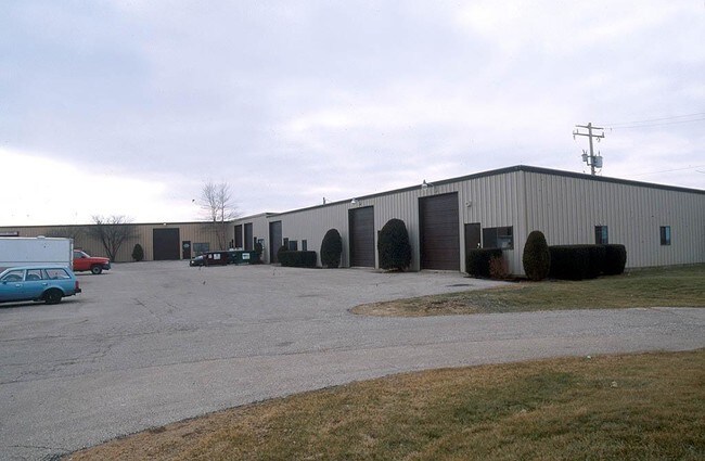
Property Record
1980 Rt 30, Sugar Grove, IL 60554

NEARBY LISTINGS FOR SALE OR LEASE
Property Detail
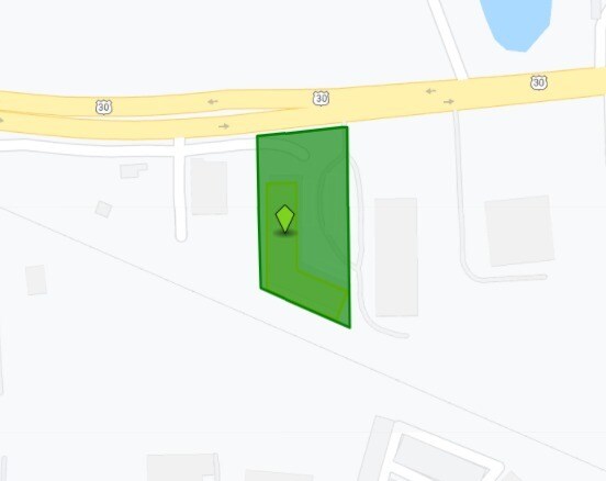
1980 Rt 30
Chicago-Naperville-Elgin, IL-IN-WI
Farrar-Hegerman Sub
14-19-105-005
LOT 2 IN FARRAR-HEGERMAN SUB (EX PT DESC IN DOC 2014K035746 FOR ROAD ROW)
Industrialgeneral
Kane
X
Illinois
17089C0315J
2
2024
1.01 AC
2024
I-88 West
854504
Chicago
DEMOGRAPHICS near 1980 Rt 30
1 Mile
3 Mile
5 Mile
2024 Total Population
269
5,970
20,949
2029 Population
266
5,998
21,365
Pop Growth 2024-2029
(1.12%)
+ 0.47%
+ 1.99%
Average Age
41
41
40
2024 Total Households
105
2,202
7,357
HH Growth 2024-2029
(1.90%)
+ 0.36%
+ 1.88%
Median Household Inc
$107,386
$115,517
$112,962
Avg Household Size
2.60
2.70
2.80
2024 Avg HH Vehicles
2.00
2.00
2.00
Median Home Value
$254,285
$299,771
$297,537
Median Year Built
1977
1997
2001
Nearby Places
Map Layers
Map Styles
 Street
 Aerial
- Restaurants
- Banks
- Shops
- Fitness
- Groceries
PUBLIC TRANSPORTATION
COMMUTER RAIL
Aurora Station (Burlington Northern-Santa Fe Railway Line - Northeast Illinois Regional Commuter Railroad (Metra))
DRIVE
WALK
Distance
Aurora Station (Burlington Northern-Santa Fe Railway Line - Northeast Illinois Regional Commuter Railroad (Metra))
19 min
9.6 mi
AIRPORT
Chicago O'Hare International
DRIVE
WALK
Distance
Chicago O'Hare International
61 min
45.0 mi
Nearby Properties
Address
Land Use
TOTAL SIZE
Lot Size
Zoning
Address
Land Use
TOTAL SIZE
Lot Size
Zoning
Address
Land Use
TOTAL SIZE
Lot Size
Zoning
1.14 AC
Address
Land Use
TOTAL SIZE
Lot Size
Zoning
Address
Land Use
TOTAL SIZE
Lot Size
Zoning
36,200 SF
5.84 AC
Address
Land Use
TOTAL SIZE
Lot Size
Zoning
Address
Land Use
TOTAL SIZE
Lot Size
Zoning
Address
Land Use
TOTAL SIZE
Lot Size
Zoning
91,579 SF
22.83 AC
Address
Land Use
TOTAL SIZE
Lot Size
Zoning
1,200 SF
1 AC
Address
Land Use
TOTAL SIZE
Lot Size
Zoning
46,284 SF
4.84 AC
Address
Land Use
TOTAL SIZE
Lot Size
Zoning
45,000 SF
3.04 AC
Address
Land Use
TOTAL SIZE
Lot Size
Zoning
Address
Land Use
TOTAL SIZE
Lot Size
Zoning
Address
Land Use
TOTAL SIZE
Lot Size
Zoning
Address
Land Use
TOTAL SIZE
Lot Size
Zoning
40,000 SF
2.92 AC
Address
Land Use
TOTAL SIZE
Lot Size
Zoning
1,128 SF
1.78 AC
Address
Land Use
TOTAL SIZE
Lot Size
Zoning
39,543 SF
1 AC
Address
Land Use
TOTAL SIZE
Lot Size
Zoning
44,000 SF
0.80 AC
Address
Land Use
TOTAL SIZE
Lot Size
Zoning
Address
Land Use
TOTAL SIZE
Lot Size
Zoning
Address
Land Use
TOTAL SIZE
Lot Size
Zoning
14,592 SF
1.82 AC
Address
Land Use
TOTAL SIZE
Lot Size
Zoning
30,108 SF
2 AC
Address
Land Use
TOTAL SIZE
Lot Size
Zoning
15,964 SF
2 AC
Address
Land Use
TOTAL SIZE
Lot Size
Zoning
36.35 AC
Address
Land Use
TOTAL SIZE
Lot Size
Zoning
39.61 AC
Address
Land Use
TOTAL SIZE
Lot Size
Zoning
20,000 SF
2 AC
Address
Land Use
TOTAL SIZE
Lot Size
Zoning
42,850 SF
2.02 AC
Address
Land Use
TOTAL SIZE
Lot Size
Zoning
24,375 SF
1.95 AC
Address
Land Use
TOTAL SIZE
Lot Size
Zoning
Address
Land Use
TOTAL SIZE
Lot Size
Zoning
1.23 AC
Address
Land Use
TOTAL SIZE
Lot Size
Zoning
10,690 SF
1 AC
The World's #1 Commercial Real Estate Marketplace
Connect with us
© 2025 CoStar Group
The information above has been obtained from sources believed reliable. While we do not doubt its accuracy we have not verified it and make no guarantee, warranty or representation about it. It is your responsibility to independently confirm its accuracy and completeness. Any projections, opinions, assumptions, or estimates used are for example only and do not represent the current or future performance of the property. The value of this transaction to you depends on tax and other factors which should be evaluated by your tax, financial, and legal advisors. You and your advisors should conduct a careful, independent investigation of the property to determine to your satisfaction the suitability of the property for your needs.