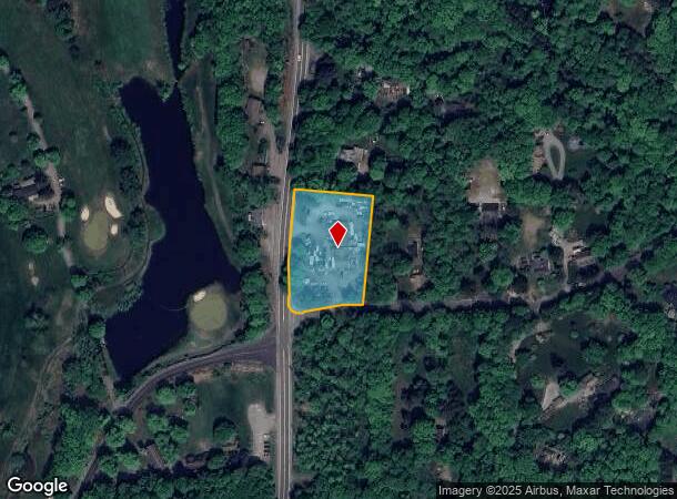
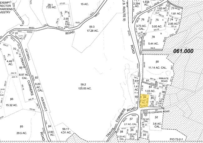
Property Record
1980 Rt 9, Philipstown, NY 10516

NEARBY LISTINGS FOR SALE OR LEASE
Property Detail
1980 Rt 9
372689-060-000-0002-084-000-0000
LAND & COMM BUILDING
Autorepair
Putnam
X
New York
36079C0093E
84.00
2024
1.47 AC
2024
Carmel
010600
Westchester/So Connecticut
4,375 SF
Dutchess County-Putnam County, NY
DEMOGRAPHICS near 1980 Rt 9
1 Mile
3 Mile
5 Mile
2024 Total Population
522
8,134
38,313
2029 Population
524
8,264
38,650
Pop Growth 2024-2029
+ 0.38%
+ 1.60%
+ 0.88%
Average Age
45
40
39
2024 Total Households
176
2,696
12,053
HH Growth 2024-2029
+ 0.57%
+ 1.56%
+ 0.70%
Median Household Inc
$136,842
$118,554
$115,651
Avg Household Size
2.60
2.70
2.70
2024 Avg HH Vehicles
2.00
2.00
2.00
Median Home Value
$737,341
$442,789
$417,100
Median Year Built
1971
1959
1959
Nearby Places
- Restaurants
- Banks
- Shops
- Fitness
- Groceries
PUBLIC TRANSPORTATION
COMMUTER RAIL
Garrison Station (Hudson Line - Metro-North Commuter Railroad Company (Metro-North))
DRIVE
WALK
Distance
Garrison Station (Hudson Line - Metro-North Commuter Railroad Company (Metro-North))
8 min
2.9 mi
Cold Spring Station (Hudson Line - Metro-North Commuter Railroad Company (Metro-North))
DRIVE
WALK
Distance
Cold Spring Station (Hudson Line - Metro-North Commuter Railroad Company (Metro-North))
15 min
5.6 mi
AIRPORT
New York Stewart International
DRIVE
WALK
Distance
New York Stewart International
39 min
27.3 mi
Westchester County
DRIVE
WALK
Distance
Westchester County
51 min
37.9 mi
Nearby Properties
Address
Land Use
TOTAL SIZE
Lot Size
Zoning
Address
Land Use
TOTAL SIZE
Lot Size
Zoning
363,657 SF
111.83 AC
B2
Address
Land Use
TOTAL SIZE
Lot Size
Zoning
19.90 AC
01
Address
Land Use
TOTAL SIZE
Lot Size
Zoning
119,474 SF
214.27 AC
R80
Address
Land Use
TOTAL SIZE
Lot Size
Zoning
78,529 SF
34.50 AC
R3
Address
Land Use
TOTAL SIZE
Lot Size
Zoning
95,159 SF
34.56 AC
B2
Address
Land Use
TOTAL SIZE
Lot Size
Zoning
42,600 SF
18.90 AC
R80
Address
Land Use
TOTAL SIZE
Lot Size
Zoning
233,706 SF
11.65 AC
R80
Address
Land Use
TOTAL SIZE
Lot Size
Zoning
Address
Land Use
TOTAL SIZE
Lot Size
Zoning
5,380 SF
8.16 AC
CD
Address
Land Use
TOTAL SIZE
Lot Size
Zoning
14,720 SF
2.50 AC
R-5
Address
Land Use
TOTAL SIZE
Lot Size
Zoning
44,052 SF
23.97 AC
R80
Address
Land Use
TOTAL SIZE
Lot Size
Zoning
12,747 SF
35.73 AC
R80
Address
Land Use
TOTAL SIZE
Lot Size
Zoning
13,650 SF
16.46 AC
R80
Address
Land Use
TOTAL SIZE
Lot Size
Zoning
43,907 SF
1.20 AC
R-5
Address
Land Use
TOTAL SIZE
Lot Size
Zoning
21,120 SF
43.91 AC
R80
Address
Land Use
TOTAL SIZE
Lot Size
Zoning
Address
Land Use
TOTAL SIZE
Lot Size
Zoning
19,138 SF
8.49 AC
R40
Address
Land Use
TOTAL SIZE
Lot Size
Zoning
17,300 SF
1.43 AC
B-1
Address
Land Use
TOTAL SIZE
Lot Size
Zoning
29,176 SF
66.77 AC
R80
Address
Land Use
TOTAL SIZE
Lot Size
Zoning
21,729 SF
7.32 AC
B1
Address
Land Use
TOTAL SIZE
Lot Size
Zoning
11,880 SF
5 AC
R80
Address
Land Use
TOTAL SIZE
Lot Size
Zoning
191,758 SF
20.03 AC
R80
Address
Land Use
TOTAL SIZE
Lot Size
Zoning
31,714 SF
13.88 AC
R2
Address
Land Use
TOTAL SIZE
Lot Size
Zoning
20,640 SF
22.22 AC
R80
Address
Land Use
TOTAL SIZE
Lot Size
Zoning
5,278 SF
67.05 AC
R3
Address
Land Use
TOTAL SIZE
Lot Size
Zoning
24,480 SF
0.55 AC
R-4
Address
Land Use
TOTAL SIZE
Lot Size
Zoning
6,056 SF
11 AC
CD
Address
Land Use
TOTAL SIZE
Lot Size
Zoning
4,552 SF
74.92 AC
CD
Address
Land Use
TOTAL SIZE
Lot Size
Zoning
6,428 SF
0.36 AC
B-1
The World's #1 Commercial Real Estate Marketplace
Connect with us
© 2025 CoStar Group
The information above has been obtained from sources believed reliable. While we do not doubt its accuracy we have not verified it and make no guarantee, warranty or representation about it. It is your responsibility to independently confirm its accuracy and completeness. Any projections, opinions, assumptions, or estimates used are for example only and do not represent the current or future performance of the property. The value of this transaction to you depends on tax and other factors which should be evaluated by your tax, financial, and legal advisors. You and your advisors should conduct a careful, independent investigation of the property to determine to your satisfaction the suitability of the property for your needs.