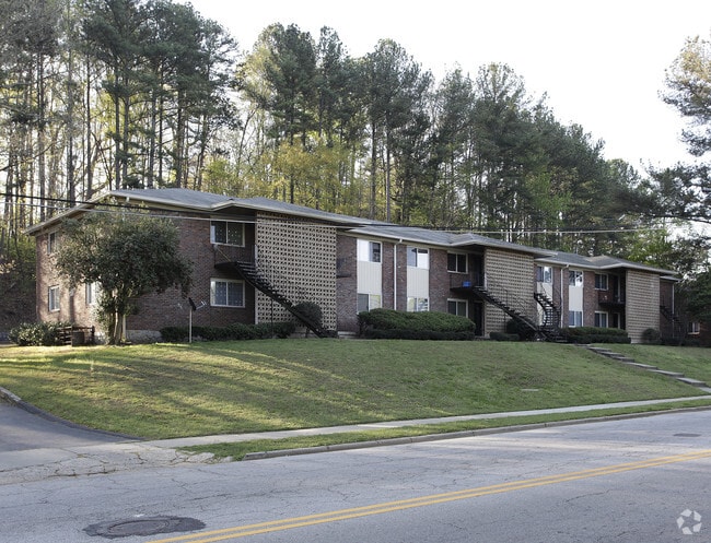
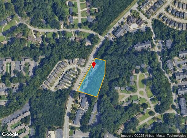
Property Record
1980 Stanton Rd, Atlanta, GA 30344

NEARBY LISTINGS FOR SALE OR LEASE
Property Detail
1980 Stanton Rd
Atlanta-Sandy Springs-Roswell, GA
Property/Perry-Eskewcorporati
14-0167-LL-031-6
1940-1982 STANTON RD
Apartment
Fulton
AE
Georgia
13121C0354F
167
2024
1.81 AC
2025
Fort McPherson
011204
Atlanta
35,936 SF
DEMOGRAPHICS near 1980 Stanton Rd
1 Mile
3 Mile
5 Mile
2024 Total Population
12,510
81,942
232,385
2029 Population
13,125
84,991
243,072
Pop Growth 2024-2029
+ 4.92%
+ 3.72%
+ 4.60%
Average Age
38
40
38
2024 Total Households
5,659
34,932
94,919
HH Growth 2024-2029
+ 4.91%
+ 3.83%
+ 4.75%
Median Household Inc
$27,194
$47,290
$44,631
Avg Household Size
2.20
2.30
2.30
2024 Avg HH Vehicles
1.00
1.00
1.00
Median Home Value
$144,702
$259,189
$250,107
Median Year Built
1966
1961
1970
Nearby Places
Map Layers
Map Styles
 Street
 Aerial
- Restaurants
- Banks
- Shops
- Fitness
- Groceries
PUBLIC TRANSPORTATION
COMMUTER RAIL
DRIVE
WALK
Distance
18 min
9.1 mi
AIRPORT
Hartsfield - Jackson Atlanta International
DRIVE
WALK
Distance
Hartsfield - Jackson Atlanta International
14 min
7.9 mi
SALE & LEASE HISTORY
LISTING DATE
SALE/LEASE

Apr 01, 2025
For Sale
Nearby Properties
Address
Land Use
TOTAL SIZE
Lot Size
Zoning
Address
Land Use
TOTAL SIZE
Lot Size
Zoning
11.74 AC
I1
Address
Land Use
TOTAL SIZE
Lot Size
Zoning
541,508 SF
110.88 AC
I1
Address
Land Use
TOTAL SIZE
Lot Size
Zoning
196,294 SF
0.49 AC
R1
Address
Land Use
TOTAL SIZE
Lot Size
Zoning
857,294 SF
101.10 AC
I1
Address
Land Use
TOTAL SIZE
Lot Size
Zoning
293,935 SF
8.47 AC
I2
Address
Land Use
TOTAL SIZE
Lot Size
Zoning
817,277 SF
21.04 AC
R3
Address
Land Use
TOTAL SIZE
Lot Size
Zoning
3,411,710 SF
25.97 AC
RG3
Address
Land Use
TOTAL SIZE
Lot Size
Zoning
425,270 SF
201.84 AC
I1
Address
Land Use
TOTAL SIZE
Lot Size
Zoning
274,442 SF
20.33 AC
RG2
Address
Land Use
TOTAL SIZE
Lot Size
Zoning
3,268,352 SF
23.31 AC
RG2
Address
Land Use
TOTAL SIZE
Lot Size
Zoning
265,437 SF
4.74 AC
CL
Address
Land Use
TOTAL SIZE
Lot Size
Zoning
563,256 SF
22.69 AC
I1
Address
Land Use
TOTAL SIZE
Lot Size
Zoning
3,289,702 SF
16.23 AC
C1C
Address
Land Use
TOTAL SIZE
Lot Size
Zoning
28.58 AC
Address
Land Use
TOTAL SIZE
Lot Size
Zoning
4.25 AC
R3
Address
Land Use
TOTAL SIZE
Lot Size
Zoning
6,834,480 SF
9.85 AC
RG3
Address
Land Use
TOTAL SIZE
Lot Size
Zoning
689,523 SF
34.32 AC
I1
Address
Land Use
TOTAL SIZE
Lot Size
Zoning
1,352,250 SF
3.18 AC
C2
Address
Land Use
TOTAL SIZE
Lot Size
Zoning
35.10 AC
R1
Address
Land Use
TOTAL SIZE
Lot Size
Zoning
2,963,779 SF
10.07 AC
C1
Address
Land Use
TOTAL SIZE
Lot Size
Zoning
54.47 AC
OI
Address
Land Use
TOTAL SIZE
Lot Size
Zoning
154,200 SF
3.09 AC
I2
Address
Land Use
TOTAL SIZE
Lot Size
Zoning
87,382 SF
83.24 AC
I1C
Address
Land Use
TOTAL SIZE
Lot Size
Zoning
764,659 SF
51.57 AC
C1
Address
Land Use
TOTAL SIZE
Lot Size
Zoning
39.06 AC
OI
Address
Land Use
TOTAL SIZE
Lot Size
Zoning
279,108 SF
6.06 AC
C2
Address
Land Use
TOTAL SIZE
Lot Size
Zoning
79,988 SF
4.05 AC
I1
Address
Land Use
TOTAL SIZE
Lot Size
Zoning
38.04 AC
I1
Address
Land Use
TOTAL SIZE
Lot Size
Zoning
910 SF
28.75 AC
R1
Address
Land Use
TOTAL SIZE
Lot Size
Zoning
1,813,648 SF
14.42 AC
RG2
The World's #1 Commercial Real Estate Marketplace
Connect with us
© 2025 CoStar Group
The information above has been obtained from sources believed reliable. While we do not doubt its accuracy we have not verified it and make no guarantee, warranty or representation about it. It is your responsibility to independently confirm its accuracy and completeness. Any projections, opinions, assumptions, or estimates used are for example only and do not represent the current or future performance of the property. The value of this transaction to you depends on tax and other factors which should be evaluated by your tax, financial, and legal advisors. You and your advisors should conduct a careful, independent investigation of the property to determine to your satisfaction the suitability of the property for your needs.