Property Record
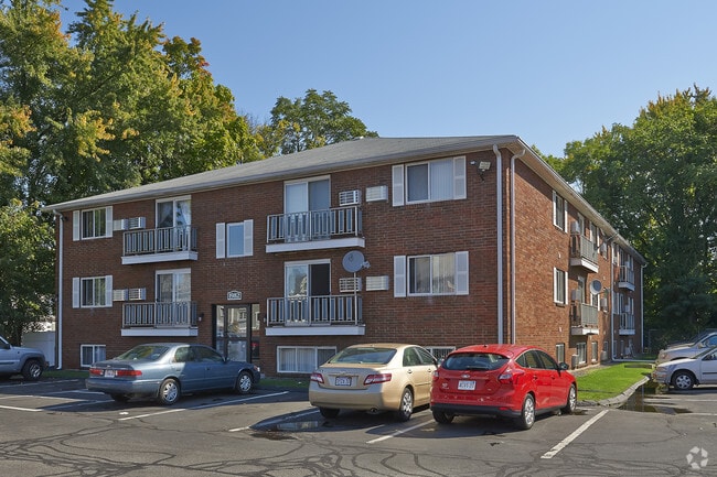
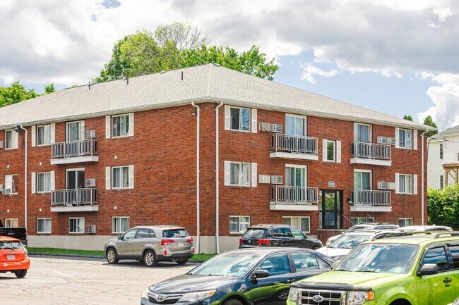
1982 Middlesex St, Lowell, MA 01851

Property Detail
1982 Middlesex St
LOWE-000034-004085-001982
Middlesex
Apartment
Massachusetts
SMF
1982
B and X Area of moderate flood hazard, usually the area between the limits of the 100-year and 500-year floods.
2.71 AC
2025
Highlands Lowell
2025
Boston
311400
Boston-Cambridge-Newton, MA-NH
NEARBY LISTINGS FOR SALE OR LEASE
DEMOGRAPHICS near 1982 Middlesex St
1 mile
3 mile
5 mile
2025 Total Population
13,337
108,464
210,333
2030 Population
13,849
111,986
217,528
Pop Growth 2025-2030
+ 3.84%
+ 3.25%
+ 3.42%
Average Age
40
39
40
2025 Total Households
5,075
39,382
76,858
HH Growth 2025-2030
+ 3.90%
+ 3.50%
+ 3.60%
Median Household Inc
$94,588
$89,623
$98,363
Avg Household Size
2.50
2.50
2.60
2025 Avg HH Vehicles
2.00
2.00
2.00
Median Home Value
$491,276
$472,019
$511,609
Median Year Built
1975
1960
1965
Nearby Places
Map Layers
Map Styles
 Street
 Aerial
Transit
 Traffic
 Biking
Places
Listings with unknown addresses are not visible on the map
- Restaurants
- Banks
- Shops
- Fitness
- Groceries
PUBLIC TRANSPORTATION
COMMUTER RAIL
Lowell (Lowell Line - Massachusetts Bay Transportation Authority Commuter Rail (Purple Line))
Drive
Walk
Distance
Lowell (Lowell Line - Massachusetts Bay Transportation Authority Commuter Rail (Purple Line))
7 min
2.9 mi
North Billerica (Lowell Line - Massachusetts Bay Transportation Authority Commuter Rail (Purple Line))
Drive
Walk
Distance
North Billerica (Lowell Line - Massachusetts Bay Transportation Authority Commuter Rail (Purple Line))
14 min
8.1 mi
AIRPORT
Manchester Boston Regional
Drive
Walk
Distance
Manchester Boston Regional
42 min
27.5 mi
General Edward Lawrence Logan International
Drive
Walk
Distance
General Edward Lawrence Logan International
51 min
37.3 mi
Worcester Regional
Drive
Walk
Distance
Worcester Regional
61 min
44.8 mi
Freight Ports
Port of Boston
Drive
Walk
Distance
Port of Boston
52 min
37.1 mi
Nearby Properties
Address
Land Use
TOTAL SIZE
Lot Size
Zoning
Address
Land Use
TOTAL SIZE
Lot Size
Zoning
9.73 AC
INST
Address
Land Use
TOTAL SIZE
Lot Size
Zoning
14.73 AC
HRC
Address
Land Use
TOTAL SIZE
Lot Size
Zoning
30,744 SF
31.28 AC
INST
Address
Land Use
TOTAL SIZE
Lot Size
Zoning
23,251 SF
18.20 AC
SMF
Address
Land Use
TOTAL SIZE
Lot Size
Zoning
275,574 SF
6.66 AC
HRCO
Address
Land Use
TOTAL SIZE
Lot Size
Zoning
224,076 SF
1.15 AC
HCD
Address
Land Use
TOTAL SIZE
Lot Size
Zoning
215,884 SF
1.55 AC
DMU
Address
Land Use
TOTAL SIZE
Lot Size
Zoning
134,439 SF
3.29 AC
DMU
Address
Land Use
TOTAL SIZE
Lot Size
Zoning
6.30 AC
UMU
Address
Land Use
TOTAL SIZE
Lot Size
Zoning
11.45 AC
TTF
Address
Land Use
TOTAL SIZE
Lot Size
Zoning
2.15 AC
INST
Address
Land Use
TOTAL SIZE
Lot Size
Zoning
19.97 AC
SSF
Address
Land Use
TOTAL SIZE
Lot Size
Zoning
59.09 AC
SSF
Address
Land Use
TOTAL SIZE
Lot Size
Zoning
6.27 AC
DMU
Address
Land Use
TOTAL SIZE
Lot Size
Zoning
225,252 SF
2.31 AC
DMU
Address
Land Use
TOTAL SIZE
Lot Size
Zoning
269,952 SF
18.11 AC
P
Address
Land Use
TOTAL SIZE
Lot Size
Zoning
68.15 AC
R1
Address
Land Use
TOTAL SIZE
Lot Size
Zoning
262,607 SF
4.33 AC
INST
Address
Land Use
TOTAL SIZE
Lot Size
Zoning
10.48 AC
INST
Address
Land Use
TOTAL SIZE
Lot Size
Zoning
7.18 AC
SMF
Address
Land Use
TOTAL SIZE
Lot Size
Zoning
168,114 SF
0.17 AC
UMU
Address
Land Use
TOTAL SIZE
Lot Size
Zoning
38.26 AC
P
Address
Land Use
TOTAL SIZE
Lot Size
Zoning
2.62 AC
INST
Address
Land Use
TOTAL SIZE
Lot Size
Zoning
26.65 AC
IA
Address
Land Use
TOTAL SIZE
Lot Size
Zoning
7.25 AC
INST
Address
Land Use
TOTAL SIZE
Lot Size
Zoning
167,201 SF
6.31 AC
DMU
Address
Land Use
TOTAL SIZE
Lot Size
Zoning
245,562 SF
1.44 AC
DMU
Address
Land Use
TOTAL SIZE
Lot Size
Zoning
63,768 SF
8.83 AC
SMU
Address
Land Use
TOTAL SIZE
Lot Size
Zoning
95,745 SF
20.32 AC
TMF
Address
Land Use
TOTAL SIZE
Lot Size
Zoning
33.01 AC
R3
The World's #1 Commercial Real Estate Marketplace
Connect with us
© 2026 CoStar Group
The information above has been obtained from sources believed reliable. While we do not doubt its accuracy we have not verified it and make no guarantee, warranty or representation about it. It is your responsibility to independently confirm its accuracy and completeness. Any projections, opinions, assumptions, or estimates used are for example only and do not represent the current or future performance of the property. The value of this transaction to you depends on tax and other factors which should be evaluated by your tax, financial, and legal advisors. You and your advisors should conduct a careful, independent investigation of the property to determine to your satisfaction the suitability of the property for your needs.