Property Record
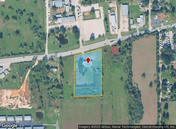
19829 Fm 2920 Rd, Tomball, TX 77377

NEARBY LISTINGS FOR SALE OR LEASE
Property Detail
19829 Fm 2920 Rd
0401890000322
Abst 7 S Brown
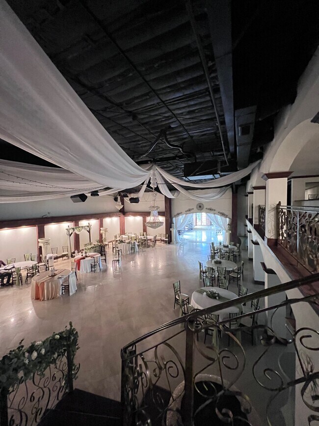
Fratsororityhouse
TR 9E-8 ABST 7 S BROWN
X
Harris
48339C0675G
Texas
2024
3.82 AC
2025
Far Northwest
555600
Houston
7,400 SF
Houston-Pasadena-The Woodlands, TX
DEMOGRAPHICS near 19829 Fm 2920 Rd
1 Mile
3 Mile
5 Mile
2024 Total Population
1,322
11,709
38,306
2029 Population
1,354
12,757
41,984
Pop Growth 2024-2029
+ 2.42%
+ 8.95%
+ 9.60%
Average Age
42
38
38
2024 Total Households
449
3,797
12,312
HH Growth 2024-2029
+ 2.45%
+ 8.82%
+ 9.96%
Median Household Inc
$133,209
$87,531
$107,506
Avg Household Size
2.80
3.00
3.10
2024 Avg HH Vehicles
2.00
2.00
2.00
Median Home Value
$442,537
$326,380
$339,700
Median Year Built
2000
2000
2004
Nearby Places
Map Layers
Map Styles
 Street
 Aerial
- Restaurants
- Banks
- Shops
- Fitness
- Groceries
PUBLIC TRANSPORTATION
AIRPORT
George Bush Intcntl/Houston
DRIVE
WALK
Distance
George Bush Intcntl/Houston
43 min
33.3 mi
William P Hobby
DRIVE
WALK
Distance
William P Hobby
71 min
48.4 mi
Freight Ports
Port of Houston
DRIVE
WALK
Distance
Port of Houston
63 min
43.9 mi
SALE & LEASE HISTORY
LISTING DATE
SALE/LEASE

Aug 15, 2023
For Lease
Nearby Properties
Address
Land Use
TOTAL SIZE
Lot Size
Zoning
Address
Land Use
TOTAL SIZE
Lot Size
Zoning
326,902 SF
15.45 AC
Address
Land Use
TOTAL SIZE
Lot Size
Zoning
280.90 AC
Address
Land Use
TOTAL SIZE
Lot Size
Zoning
123,400 SF
15.08 AC
Address
Land Use
TOTAL SIZE
Lot Size
Zoning
55,800 SF
25.95 AC
Address
Land Use
TOTAL SIZE
Lot Size
Zoning
238.57 AC
Address
Land Use
TOTAL SIZE
Lot Size
Zoning
210.95 AC
Address
Land Use
TOTAL SIZE
Lot Size
Zoning
27,542 SF
4.44 AC
Address
Land Use
TOTAL SIZE
Lot Size
Zoning
74,400 SF
6.43 AC
Address
Land Use
TOTAL SIZE
Lot Size
Zoning
57,059 SF
83.47 AC
Address
Land Use
TOTAL SIZE
Lot Size
Zoning
62,322 SF
15.82 AC
Address
Land Use
TOTAL SIZE
Lot Size
Zoning
39,320 SF
6.46 AC
Address
Land Use
TOTAL SIZE
Lot Size
Zoning
83,930 SF
4.74 AC
Address
Land Use
TOTAL SIZE
Lot Size
Zoning
73,040 SF
5.22 AC
Address
Land Use
TOTAL SIZE
Lot Size
Zoning
113,545 SF
8.24 AC
Address
Land Use
TOTAL SIZE
Lot Size
Zoning
Address
Land Use
TOTAL SIZE
Lot Size
Zoning
25,063 SF
5 AC
Address
Land Use
TOTAL SIZE
Lot Size
Zoning
85,700 SF
6 AC
Address
Land Use
TOTAL SIZE
Lot Size
Zoning
6,729 SF
98.17 AC
Address
Land Use
TOTAL SIZE
Lot Size
Zoning
24,324 SF
2.29 AC
Address
Land Use
TOTAL SIZE
Lot Size
Zoning
81.64 AC
Address
Land Use
TOTAL SIZE
Lot Size
Zoning
94.79 AC
Address
Land Use
TOTAL SIZE
Lot Size
Zoning
Address
Land Use
TOTAL SIZE
Lot Size
Zoning
20,581 SF
14.85 AC
Address
Land Use
TOTAL SIZE
Lot Size
Zoning
3,428 SF
12.76 AC
Address
Land Use
TOTAL SIZE
Lot Size
Zoning
52.94 AC
Address
Land Use
TOTAL SIZE
Lot Size
Zoning
22.95 AC
Address
Land Use
TOTAL SIZE
Lot Size
Zoning
10,680 SF
2.45 AC
Address
Land Use
TOTAL SIZE
Lot Size
Zoning
3,000 SF
16.95 AC
Address
Land Use
TOTAL SIZE
Lot Size
Zoning
43,000 SF
7.22 AC
Address
Land Use
TOTAL SIZE
Lot Size
Zoning
66.95 AC
The World's #1 Commercial Real Estate Marketplace
Connect with us
© 2026 CoStar Group
The information above has been obtained from sources believed reliable. While we do not doubt its accuracy we have not verified it and make no guarantee, warranty or representation about it. It is your responsibility to independently confirm its accuracy and completeness. Any projections, opinions, assumptions, or estimates used are for example only and do not represent the current or future performance of the property. The value of this transaction to you depends on tax and other factors which should be evaluated by your tax, financial, and legal advisors. You and your advisors should conduct a careful, independent investigation of the property to determine to your satisfaction the suitability of the property for your needs.