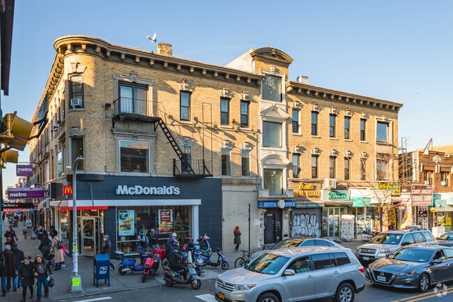
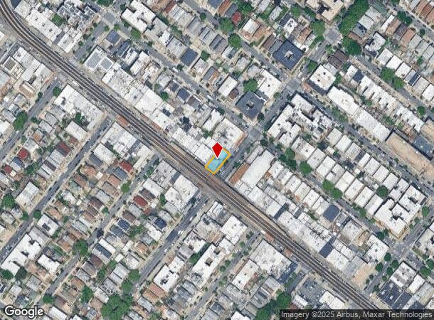
Property Record
1979 86Th St, Brooklyn, NY 11214
NEARBY LISTINGS FOR SALE OR LEASE
Property Detail
1979 86Th St
06345-0039
Kings
Storebuilding
New York
X
39
3604970351F
0.10 AC
2024
South Brooklyn
2025
Long Island (New York)
029000
New York-Jersey City-White Plains, NY-NJ
10,800 SF
DEMOGRAPHICS near 1979 86Th St
1 Mile
3 Mile
5 Mile
2024 Total Population
121,829
830,887
1,417,907
2029 Population
110,933
770,723
1,324,943
Pop Growth 2024-2029
(8.94%)
(7.24%)
(6.56%)
Average Age
41
40
40
2024 Total Households
40,616
282,713
499,902
HH Growth 2024-2029
(9.57%)
(7.52%)
(6.83%)
Median Household Inc
$60,555
$60,026
$67,630
Avg Household Size
2.90
2.80
2.70
2024 Avg HH Vehicles
1.00
1.00
1.00
Median Home Value
$915,549
$846,612
$791,720
Median Year Built
1947
1948
1948
Nearby Places
Map Layers
Map Styles
 Street
 Aerial
- Restaurants
- Banks
- Shops
- Fitness
- Groceries
PUBLIC TRANSPORTATION
TRANSIT/SUBWAY
20 Avenue (D,M Line) (D - New York MTA Subway (The Subway), M - New York MTA Subway (The Subway))
DRIVE
WALK
Distance
20 Avenue (D,M Line) (D - New York MTA Subway (The Subway), M - New York MTA Subway (The Subway))
0 min
0 min
0.0 mi
Bay Parkway (D,M Line) (D - New York MTA Subway (The Subway), M - New York MTA Subway (The Subway))
DRIVE
WALK
Distance
Bay Parkway (D,M Line) (D - New York MTA Subway (The Subway), M - New York MTA Subway (The Subway))
1 min
6 min
0.3 mi
18 Avenue (D,M Line) (D - New York MTA Subway (The Subway), M - New York MTA Subway (The Subway))
DRIVE
WALK
Distance
18 Avenue (D,M Line) (D - New York MTA Subway (The Subway), M - New York MTA Subway (The Subway))
1 min
7 min
0.3 mi
79 Street (D,M Line) (D - New York MTA Subway (The Subway), M - New York MTA Subway (The Subway))
DRIVE
WALK
Distance
79 Street (D,M Line) (D - New York MTA Subway (The Subway), M - New York MTA Subway (The Subway))
3 min
14 min
0.7 mi
25 Avenue (D - New York MTA Subway (The Subway))
DRIVE
WALK
Distance
25 Avenue (D - New York MTA Subway (The Subway))
2 min
15 min
0.8 mi
COMMUTER RAIL
Grasmere (Staten Island Railway - New York MTA Subway (The Subway))
DRIVE
WALK
Distance
Grasmere (Staten Island Railway - New York MTA Subway (The Subway))
12 min
5.8 mi
Old Town (Staten Island Railway - New York MTA Subway (The Subway))
DRIVE
WALK
Distance
Old Town (Staten Island Railway - New York MTA Subway (The Subway))
13 min
6.0 mi
AIRPORT
John F Kennedy International
DRIVE
WALK
Distance
John F Kennedy International
26 min
18.0 mi
LaGuardia
DRIVE
WALK
Distance
LaGuardia
32 min
18.2 mi
Newark Liberty International
DRIVE
WALK
Distance
Newark Liberty International
34 min
21.0 mi
Freight Ports
NY - Red Hook Container Terminal
DRIVE
WALK
Distance
NY - Red Hook Container Terminal
13 min
7.1 mi
SALE & LEASE HISTORY
LISTING DATE
SALE/LEASE

May 30, 2019
For Lease
Jun 04, 2020
For Lease
Apr 21, 2025
For Lease
Nearby Properties
Address
Land Use
TOTAL SIZE
Lot Size
Zoning
Address
Land Use
TOTAL SIZE
Lot Size
Zoning
1,524,659 SF
170.96 AC
R4
Address
Land Use
TOTAL SIZE
Lot Size
Zoning
1,078,317 SF
10.45 AC
R4
Address
Land Use
TOTAL SIZE
Lot Size
Zoning
965,600 SF
6.65 AC
R5
Address
Land Use
TOTAL SIZE
Lot Size
Zoning
335,800 SF
1.51 AC
R6
Address
Land Use
TOTAL SIZE
Lot Size
Zoning
54.78 AC
PARK
Address
Land Use
TOTAL SIZE
Lot Size
Zoning
785,450 SF
14.22 AC
R6
Address
Land Use
TOTAL SIZE
Lot Size
Zoning
286,000 SF
12.63 AC
PARK
Address
Land Use
TOTAL SIZE
Lot Size
Zoning
301,400 SF
22.27 AC
M3-1
Address
Land Use
TOTAL SIZE
Lot Size
Zoning
139,557 SF
11.47 AC
M1-1
Address
Land Use
TOTAL SIZE
Lot Size
Zoning
846,056 SF
20.71 AC
R5
Address
Land Use
TOTAL SIZE
Lot Size
Zoning
59,063 SF
21.56 AC
PARK
Address
Land Use
TOTAL SIZE
Lot Size
Zoning
209,346 SF
18.29 AC
PARK
Address
Land Use
TOTAL SIZE
Lot Size
Zoning
702,770 SF
4.47 AC
R6
Address
Land Use
TOTAL SIZE
Lot Size
Zoning
292,528 SF
1.05 AC
R6
Address
Land Use
TOTAL SIZE
Lot Size
Zoning
152,440 SF
23.07 AC
R4B
Address
Land Use
TOTAL SIZE
Lot Size
Zoning
43,068 SF
216.83 AC
PARK
Address
Land Use
TOTAL SIZE
Lot Size
Zoning
356,000 SF
8.19 AC
R5
Address
Land Use
TOTAL SIZE
Lot Size
Zoning
351,762 SF
1.65 AC
R7A
Address
Land Use
TOTAL SIZE
Lot Size
Zoning
208,015 SF
1.52 AC
R7X
Address
Land Use
TOTAL SIZE
Lot Size
Zoning
221,704 SF
0.83 AC
R5B
Address
Land Use
TOTAL SIZE
Lot Size
Zoning
128,170 SF
0.87 AC
R7A
Address
Land Use
TOTAL SIZE
Lot Size
Zoning
470,000 SF
3.40 AC
R6
Address
Land Use
TOTAL SIZE
Lot Size
Zoning
16,570 SF
240.82 AC
PARK
Address
Land Use
TOTAL SIZE
Lot Size
Zoning
414,400 SF
2.70 AC
R7A
Address
Land Use
TOTAL SIZE
Lot Size
Zoning
105,328 SF
0.11 AC
M1-6
Address
Land Use
TOTAL SIZE
Lot Size
Zoning
219,973 SF
0.39 AC
R8
Address
Land Use
TOTAL SIZE
Lot Size
Zoning
131,650 SF
0.83 AC
R6
Address
Land Use
TOTAL SIZE
Lot Size
Zoning
60,288 SF
0.76 AC
R5
Address
Land Use
TOTAL SIZE
Lot Size
Zoning
305,046 SF
8.76 AC
R6
Address
Land Use
TOTAL SIZE
Lot Size
Zoning
211,552 SF
7.39 AC
R3-2
The World's #1 Commercial Real Estate Marketplace
Connect with us
© 2026 CoStar Group
The information above has been obtained from sources believed reliable. While we do not doubt its accuracy we have not verified it and make no guarantee, warranty or representation about it. It is your responsibility to independently confirm its accuracy and completeness. Any projections, opinions, assumptions, or estimates used are for example only and do not represent the current or future performance of the property. The value of this transaction to you depends on tax and other factors which should be evaluated by your tax, financial, and legal advisors. You and your advisors should conduct a careful, independent investigation of the property to determine to your satisfaction the suitability of the property for your needs.