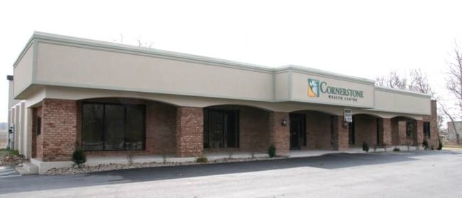
Property Record
19833 Leitersburg Pike, Hagerstown, MD 21742


Current Lease Availabilities
NEARBY LISTINGS FOR SALE OR LEASE
Property Detail
19833 Leitersburg Pike
09-007695
3.44 ACRES 19833 LEITERSBURG PIKE
Officebuilding
Washington
AE
Maryland
24043C0141D
3.44 AC
2024
Washington County
2025
Washington, DC
011202
Hagerstown-Martinsburg, MD-WV
22,470 SF
DEMOGRAPHICS near 19833 Leitersburg Pike
1 Mile
3 Mile
5 Mile
2024 Total Population
1,606
26,758
78,993
2029 Population
1,646
27,064
79,927
Pop Growth 2024-2029
+ 2.49%
+ 1.14%
+ 1.18%
Average Age
47
41
40
2024 Total Households
696
10,643
31,592
HH Growth 2024-2029
+ 2.73%
+ 1.26%
+ 1.23%
Median Household Inc
$69,807
$68,271
$55,301
Avg Household Size
2.30
2.50
2.40
2024 Avg HH Vehicles
2.00
2.00
2.00
Median Home Value
$337,005
$244,928
$219,450
Median Year Built
1991
1973
1970
Nearby Places
Map Layers
Map Styles
 Street
 Aerial
- Restaurants
- Banks
- Shops
- Fitness
- Groceries
PUBLIC TRANSPORTATION
AIRPORT
Hagerstown Regional/Richard A Henson Field
DRIVE
WALK
Distance
Hagerstown Regional/Richard A Henson Field
10 min
4.3 mi
Freight Ports
Port of Baltimore
DRIVE
WALK
Distance
Port of Baltimore
96 min
78.4 mi
Nearby Properties
Address
Land Use
TOTAL SIZE
Lot Size
Zoning
Address
Land Use
TOTAL SIZE
Lot Size
Zoning
1,190,700 SF
83.26 AC
HI
Address
Land Use
TOTAL SIZE
Lot Size
Zoning
36,685 SF
281.72 AC
IG
Address
Land Use
TOTAL SIZE
Lot Size
Zoning
216 SF
52.93 AC
RH
Address
Land Use
TOTAL SIZE
Lot Size
Zoning
151,660 SF
56.24 AC
RMOD
Address
Land Use
TOTAL SIZE
Lot Size
Zoning
5,090 SF
25.27 AC
RMOD
Address
Land Use
TOTAL SIZE
Lot Size
Zoning
71,928 SF
24.77 AC
RMOD
Address
Land Use
TOTAL SIZE
Lot Size
Zoning
17,574 SF
13.98 AC
RH
Address
Land Use
TOTAL SIZE
Lot Size
Zoning
23,086 SF
19.36 AC
CR
Address
Land Use
TOTAL SIZE
Lot Size
Zoning
3,159 SF
14.99 AC
CR
Address
Land Use
TOTAL SIZE
Lot Size
Zoning
35,402 SF
10.18 AC
BG
Address
Land Use
TOTAL SIZE
Lot Size
Zoning
54,843 SF
3.08 AC
POM
Address
Land Use
TOTAL SIZE
Lot Size
Zoning
84,796 SF
8.81 AC
PB
Address
Land Use
TOTAL SIZE
Lot Size
Zoning
78,042 SF
11 AC
RB-E
Address
Land Use
TOTAL SIZE
Lot Size
Zoning
51,773 SF
11.96 AC
HI
Address
Land Use
TOTAL SIZE
Lot Size
Zoning
1,152 SF
27.83 AC
U
Address
Land Use
TOTAL SIZE
Lot Size
Zoning
7,273 SF
146.87 AC
AR
Address
Land Use
TOTAL SIZE
Lot Size
Zoning
139,403 SF
15.06 AC
CR
Address
Land Use
TOTAL SIZE
Lot Size
Zoning
102,782 SF
12.92 AC
RMOD
Address
Land Use
TOTAL SIZE
Lot Size
Zoning
287,625 SF
19.69 AC
IG
Address
Land Use
TOTAL SIZE
Lot Size
Zoning
20,312 SF
17.59 AC
U
Address
Land Use
TOTAL SIZE
Lot Size
Zoning
12.19 AC
RH
Address
Land Use
TOTAL SIZE
Lot Size
Zoning
34,110 SF
8.03 AC
HI
Address
Land Use
TOTAL SIZE
Lot Size
Zoning
43,600 SF
3.71 AC
HI
Address
Land Use
TOTAL SIZE
Lot Size
Zoning
6,077 SF
8.82 AC
U
Address
Land Use
TOTAL SIZE
Lot Size
Zoning
35,965 SF
68.88 AC
RMED
Address
Land Use
TOTAL SIZE
Lot Size
Zoning
47,923 SF
10.25 AC
RS
Address
Land Use
TOTAL SIZE
Lot Size
Zoning
7.11 AC
PB
Address
Land Use
TOTAL SIZE
Lot Size
Zoning
35,460 SF
8.32 AC
RT PU
Address
Land Use
TOTAL SIZE
Lot Size
Zoning
35,758 SF
5.06 AC
RMOD
Address
Land Use
TOTAL SIZE
Lot Size
Zoning
53,406 SF
13.10 AC
RMOD
The World's #1 Commercial Real Estate Marketplace
Connect with us
© 2026 CoStar Group
The information above has been obtained from sources believed reliable. While we do not doubt its accuracy we have not verified it and make no guarantee, warranty or representation about it. It is your responsibility to independently confirm its accuracy and completeness. Any projections, opinions, assumptions, or estimates used are for example only and do not represent the current or future performance of the property. The value of this transaction to you depends on tax and other factors which should be evaluated by your tax, financial, and legal advisors. You and your advisors should conduct a careful, independent investigation of the property to determine to your satisfaction the suitability of the property for your needs.