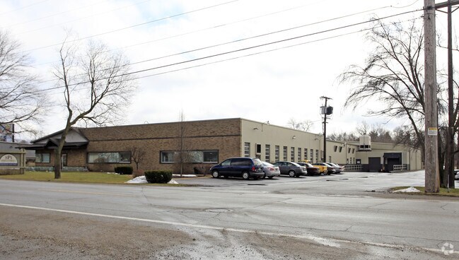
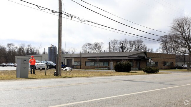
Property Record
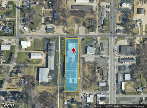
19850 St Line Rd Spi Ind Rd, South Bend, IN 46637
NEARBY LISTINGS FOR SALE OR LEASE
Property Detail
19850 St Line Rd Spi Ind Rd
South Bend-Mishawaka, IN-MI
82-93 Mich- Inda Addn
71-03-12-153-002.000-003
LOTS 1-3. 82-93 MICH- INDA ADDN & N1/2 VAC WEDGEWOOD ST & ADJ 22/23 CONS W/ 3840 & 3843 PER ASSESS IC 6 1.1516 20/21 CONW/ -3819 -3830 -3831-3834 & -3837 PER ASSESSORS REQ IC 6-1.1-5-16
Lightindustrial
St Joseph
X
Indiana
18141C0070D
1-3
2024
2.41 AC
2024
Outlying St Joseph County
011308
South Bend/Mishawaka
52,528 SF
DEMOGRAPHICS near 19850 St Line Rd Spi Ind Rd
1 Mile
3 Mile
5 Mile
2024 Total Population
2,912
27,664
86,613
2029 Population
2,872
27,242
85,959
Pop Growth 2024-2029
(1.37%)
(1.53%)
(0.76%)
Average Age
43
43
39
2024 Total Households
1,120
11,420
32,538
HH Growth 2024-2029
(1.43%)
(1.60%)
(0.82%)
Median Household Inc
$65,555
$81,567
$68,169
Avg Household Size
2.30
2.40
2.30
2024 Avg HH Vehicles
2.00
2.00
2.00
Median Home Value
$150,775
$183,846
$177,436
Median Year Built
1957
1976
1973
Nearby Places
- Restaurants
- Banks
- Shops
- Fitness
- Groceries
PUBLIC TRANSPORTATION
COMMUTER RAIL
DRIVE
WALK
Distance
10 min
5.8 mi
South Bend Airport Station (South Shore Line - Northern Indiana Commuter Transportation District (South Shore Line))
DRIVE
WALK
Distance
South Bend Airport Station (South Shore Line - Northern Indiana Commuter Transportation District (South Shore Line))
18 min
7.7 mi
AIRPORT
South Bend International
DRIVE
WALK
Distance
South Bend International
28 min
10.6 mi
Nearby Properties
Address
Land Use
TOTAL SIZE
Lot Size
Zoning
Address
Land Use
TOTAL SIZE
Lot Size
Zoning
799,664 SF
0.01 AC
Address
Land Use
TOTAL SIZE
Lot Size
Zoning
356,520 SF
28.07 AC
Address
Land Use
TOTAL SIZE
Lot Size
Zoning
157,702 SF
44 SF
Address
Land Use
TOTAL SIZE
Lot Size
Zoning
63,780 SF
44 SF
Address
Land Use
TOTAL SIZE
Lot Size
Zoning
63,374 SF
1.99 AC
Address
Land Use
TOTAL SIZE
Lot Size
Zoning
33,936 SF
1.84 AC
GB
Address
Land Use
TOTAL SIZE
Lot Size
Zoning
62,968 SF
2.66 AC
Address
Land Use
TOTAL SIZE
Lot Size
Zoning
164,768 SF
24.57 AC
GB
Address
Land Use
TOTAL SIZE
Lot Size
Zoning
215,252 SF
18.33 AC
Address
Land Use
TOTAL SIZE
Lot Size
Zoning
80,666 SF
3.41 AC
Address
Land Use
TOTAL SIZE
Lot Size
Zoning
41,512 SF
1.37 AC
Address
Land Use
TOTAL SIZE
Lot Size
Zoning
40,244 SF
2.15 AC
Address
Land Use
TOTAL SIZE
Lot Size
Zoning
135,152 SF
8.76 AC
GB
Address
Land Use
TOTAL SIZE
Lot Size
Zoning
20,553 SF
44 SF
Address
Land Use
TOTAL SIZE
Lot Size
Zoning
58,646 SF
1 AC
Address
Land Use
TOTAL SIZE
Lot Size
Zoning
93,452 SF
44 SF
Address
Land Use
TOTAL SIZE
Lot Size
Zoning
72,906 SF
2.73 AC
Address
Land Use
TOTAL SIZE
Lot Size
Zoning
55,137 SF
1.90 AC
Address
Land Use
TOTAL SIZE
Lot Size
Zoning
300,000 SF
65.30 AC
I
Address
Land Use
TOTAL SIZE
Lot Size
Zoning
40,373 SF
5.23 AC
Address
Land Use
TOTAL SIZE
Lot Size
Zoning
46,764 SF
0.92 AC
Address
Land Use
TOTAL SIZE
Lot Size
Zoning
26,140 SF
131 SF
Address
Land Use
TOTAL SIZE
Lot Size
Zoning
49,914 SF
6.18 AC
GB
Address
Land Use
TOTAL SIZE
Lot Size
Zoning
42,210 SF
15.08 AC
Address
Land Use
TOTAL SIZE
Lot Size
Zoning
15,208 SF
1.01 AC
Address
Land Use
TOTAL SIZE
Lot Size
Zoning
23,208 SF
44 SF
Address
Land Use
TOTAL SIZE
Lot Size
Zoning
49,869 SF
10.16 AC
Address
Land Use
TOTAL SIZE
Lot Size
Zoning
35,016 SF
3.50 AC
Address
Land Use
TOTAL SIZE
Lot Size
Zoning
5,075 SF
36.90 AC
R-3
The World's #1 Commercial Real Estate Marketplace
Connect with us
© 2025 CoStar Group
The information above has been obtained from sources believed reliable. While we do not doubt its accuracy we have not verified it and make no guarantee, warranty or representation about it. It is your responsibility to independently confirm its accuracy and completeness. Any projections, opinions, assumptions, or estimates used are for example only and do not represent the current or future performance of the property. The value of this transaction to you depends on tax and other factors which should be evaluated by your tax, financial, and legal advisors. You and your advisors should conduct a careful, independent investigation of the property to determine to your satisfaction the suitability of the property for your needs.