Property Record
1986 W 6Th St, Brooklyn, NY 11223
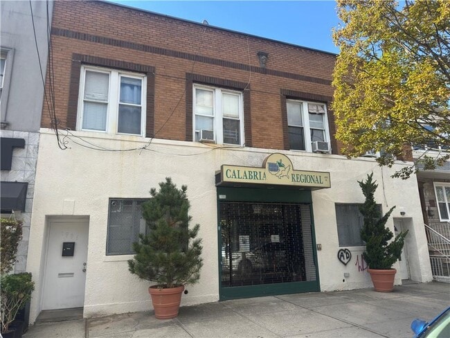

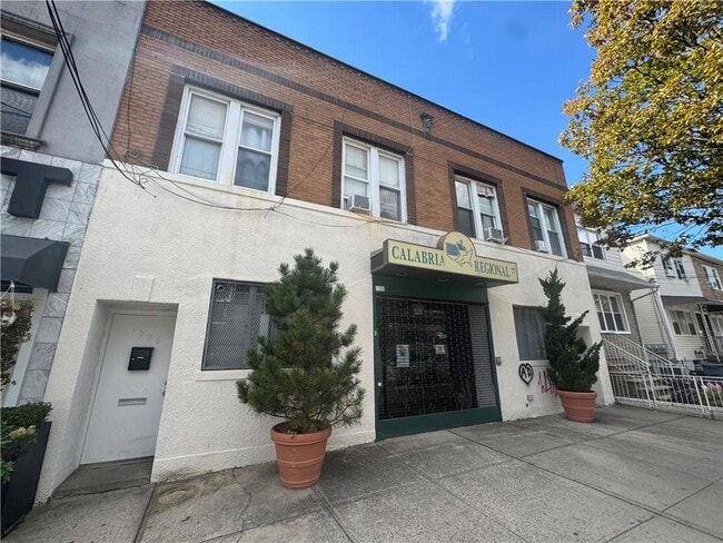
This Property Is For Sale
Property Detail
1986 W 6Th St
07082-0041
Kings
Storebuilding
New York
R5B
41
B and X Area of moderate flood hazard, usually the area between the limits of the 100-year and 500-year floods.
0.06 AC
2024
South Brooklyn
2025
Long Island (New York)
040800
New York-Jersey City-White Plains, NY-NJ
4,480 SF
NEARBY LISTINGS FOR SALE OR LEASE
DEMOGRAPHICS near 1986 W 6Th St
1 mile
3 mile
5 mile
2025 Total Population
131,296
794,529
1,423,968
2030 Population
127,314
779,207
1,395,255
Pop Growth 2025-2030
(3.03%)
(1.93%)
(2.02%)
Average Age
41
41
41
2025 Total Households
44,394
269,734
495,984
HH Growth 2025-2030
(3.46%)
(2.14%)
(2.18%)
Median Household Inc
$67,762
$66,828
$74,194
Avg Household Size
2.80
2.80
2.70
2025 Avg HH Vehicles
1.00
1.00
1.00
Median Home Value
$1,012,473
$874,984
$852,531
Median Year Built
1948
1948
1948
Nearby Places
Map Layers
Map Styles
 Street
 Aerial
Transit
 Traffic
 Biking
Places
Listings with unknown addresses are not visible on the map
- Restaurants
- Banks
- Shops
- Fitness
- Groceries
PUBLIC TRANSPORTATION
TRANSIT/SUBWAY
Avenue U (N Line) (N - New York MTA Subway (The Subway))
Drive
Walk
Distance
Avenue U (N Line) (N - New York MTA Subway (The Subway))
1 min
3 min
0.2 mi
Avenue U (F Line) (F - New York MTA Subway (The Subway))
Drive
Walk
Distance
Avenue U (F Line) (F - New York MTA Subway (The Subway))
1 min
8 min
0.4 mi
Kings Highway (N Line) (N - New York MTA Subway (The Subway))
Drive
Walk
Distance
Kings Highway (N Line) (N - New York MTA Subway (The Subway))
2 min
9 min
0.5 mi
Kings Highway (F Line) (F - New York MTA Subway (The Subway))
Drive
Walk
Distance
Kings Highway (F Line) (F - New York MTA Subway (The Subway))
1 min
10 min
0.5 mi
Gravesend-86 Street (N - New York MTA Subway (The Subway))
Drive
Walk
Distance
Gravesend-86 Street (N - New York MTA Subway (The Subway))
2 min
10 min
0.5 mi
COMMUTER RAIL
Clifton (Staten Island Railway - New York MTA Subway (The Subway))
Drive
Walk
Distance
Clifton (Staten Island Railway - New York MTA Subway (The Subway))
16 min
7.8 mi
Stapleton (Staten Island Railway - New York MTA Subway (The Subway))
Drive
Walk
Distance
Stapleton (Staten Island Railway - New York MTA Subway (The Subway))
18 min
8.5 mi
AIRPORT
John F Kennedy International
Drive
Walk
Distance
John F Kennedy International
25 min
16.8 mi
LaGuardia
Drive
Walk
Distance
LaGuardia
33 min
18.2 mi
Newark Liberty International
Drive
Walk
Distance
Newark Liberty International
37 min
22.4 mi
Freight Ports
NY - Red Hook Container Terminal
Drive
Walk
Distance
NY - Red Hook Container Terminal
13 min
7.1 mi
Nearby Properties
Address
Land Use
TOTAL SIZE
Lot Size
Zoning
Address
Land Use
TOTAL SIZE
Lot Size
Zoning
1,524,659 SF
170.96 AC
R4
Address
Land Use
TOTAL SIZE
Lot Size
Zoning
1,078,317 SF
10.45 AC
R4
Address
Land Use
TOTAL SIZE
Lot Size
Zoning
965,600 SF
6.65 AC
R5
Address
Land Use
TOTAL SIZE
Lot Size
Zoning
1,073,920 SF
16.53 AC
R6
Address
Land Use
TOTAL SIZE
Lot Size
Zoning
335,800 SF
1.51 AC
R6
Address
Land Use
TOTAL SIZE
Lot Size
Zoning
54.78 AC
PARK
Address
Land Use
TOTAL SIZE
Lot Size
Zoning
785,450 SF
14.22 AC
R6
Address
Land Use
TOTAL SIZE
Lot Size
Zoning
353,600 SF
55.79 AC
R3-1
Address
Land Use
TOTAL SIZE
Lot Size
Zoning
241,735 SF
1.99 AC
C8-4
Address
Land Use
TOTAL SIZE
Lot Size
Zoning
301,400 SF
22.27 AC
M3-1
Address
Land Use
TOTAL SIZE
Lot Size
Zoning
139,557 SF
11.47 AC
M1-1
Address
Land Use
TOTAL SIZE
Lot Size
Zoning
275,163 SF
9.69 AC
R3-1
Address
Land Use
TOTAL SIZE
Lot Size
Zoning
846,056 SF
20.71 AC
R5
Address
Land Use
TOTAL SIZE
Lot Size
Zoning
59,063 SF
21.56 AC
PARK
Address
Land Use
TOTAL SIZE
Lot Size
Zoning
209,346 SF
18.29 AC
PARK
Address
Land Use
TOTAL SIZE
Lot Size
Zoning
702,770 SF
4.47 AC
R6
Address
Land Use
TOTAL SIZE
Lot Size
Zoning
292,528 SF
1.05 AC
R6
Address
Land Use
TOTAL SIZE
Lot Size
Zoning
152,440 SF
23.07 AC
R4B
Address
Land Use
TOTAL SIZE
Lot Size
Zoning
356,000 SF
8.19 AC
R5
Address
Land Use
TOTAL SIZE
Lot Size
Zoning
351,762 SF
1.65 AC
R7A
Address
Land Use
TOTAL SIZE
Lot Size
Zoning
208,015 SF
1.52 AC
R7X
Address
Land Use
TOTAL SIZE
Lot Size
Zoning
221,704 SF
0.83 AC
R5B
Address
Land Use
TOTAL SIZE
Lot Size
Zoning
822,192 SF
14.15 AC
R6
Address
Land Use
TOTAL SIZE
Lot Size
Zoning
128,170 SF
0.87 AC
R7A
Address
Land Use
TOTAL SIZE
Lot Size
Zoning
470,000 SF
3.40 AC
R6
Address
Land Use
TOTAL SIZE
Lot Size
Zoning
16,570 SF
240.82 AC
PARK
Address
Land Use
TOTAL SIZE
Lot Size
Zoning
105,328 SF
0.11 AC
M1-6
Address
Land Use
TOTAL SIZE
Lot Size
Zoning
521,976 SF
13.59 AC
R5
Address
Land Use
TOTAL SIZE
Lot Size
Zoning
131,650 SF
0.83 AC
R6
Address
Land Use
TOTAL SIZE
Lot Size
Zoning
2,000 SF
73.29 AC
PARK
The World's #1 Commercial Real Estate Marketplace
Connect with us
© 2026 CoStar Group
The information above has been obtained from sources believed reliable. While we do not doubt its accuracy we have not verified it and make no guarantee, warranty or representation about it. It is your responsibility to independently confirm its accuracy and completeness. Any projections, opinions, assumptions, or estimates used are for example only and do not represent the current or future performance of the property. The value of this transaction to you depends on tax and other factors which should be evaluated by your tax, financial, and legal advisors. You and your advisors should conduct a careful, independent investigation of the property to determine to your satisfaction the suitability of the property for your needs.