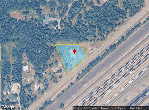
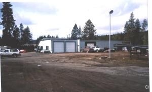
Property Record
19897 W Highway 53, Rathdrum, ID 83858

NEARBY LISTINGS FOR SALE OR LEASE
-
-
View all Rathdrum listings for sale on LoopNet.com
Property Detail
19897 W Highway 53
0290010009AA
Greenacres
Loftbuilding
GREENACRES IRR DISTRICT PLAT 2, TAX #6429 [TRS 9 & 10] 1051N05W
X
Kootenai
16055C0225E
Idaho
2025
1.52 AC
2025
Post Falls
000304
Other Market Areas
5,245 SF
Coeur d'Alene, ID
DEMOGRAPHICS near 19897 W Highway 53
1 Mile
3 Mile
5 Mile
2024 Total Population
543
9,576
48,345
2029 Population
642
11,461
57,714
Pop Growth 2024-2029
+ 18.23%
+ 19.68%
+ 19.38%
Average Age
42
39
38
2024 Total Households
199
3,513
17,733
HH Growth 2024-2029
+ 17.59%
+ 19.30%
+ 18.99%
Median Household Inc
$81,111
$78,651
$74,835
Avg Household Size
2.70
2.70
2.70
2024 Avg HH Vehicles
3.00
2.00
2.00
Median Home Value
$401,220
$453,437
$416,442
Median Year Built
1990
2004
2005
Nearby Places
Map Layers
Map Styles
 Street
 Aerial
- Restaurants
- Banks
- Shops
- Fitness
- Groceries
PUBLIC TRANSPORTATION
AIRPORT
Spokane International
DRIVE
WALK
Distance
Spokane International
44 min
33.4 mi
Freight Ports
Port of Everett
DRIVE
WALK
Distance
Port of Everett
372 min
328.9 mi
Nearby Properties
Address
Land Use
TOTAL SIZE
Lot Size
Zoning
Address
Land Use
TOTAL SIZE
Lot Size
Zoning
104,852 SF
5.70 AC
Address
Land Use
TOTAL SIZE
Lot Size
Zoning
94,960 SF
7.45 AC
Address
Land Use
TOTAL SIZE
Lot Size
Zoning
12,600 SF
29.04 AC
Address
Land Use
TOTAL SIZE
Lot Size
Zoning
14,159 SF
17.50 AC
Address
Land Use
TOTAL SIZE
Lot Size
Zoning
134,124 SF
43.63 AC
AG
Address
Land Use
TOTAL SIZE
Lot Size
Zoning
48,264 SF
10.87 AC
Address
Land Use
TOTAL SIZE
Lot Size
Zoning
79,232 SF
6.06 AC
Address
Land Use
TOTAL SIZE
Lot Size
Zoning
42,000 SF
2.54 AC
Address
Land Use
TOTAL SIZE
Lot Size
Zoning
60,220 SF
2.70 AC
Address
Land Use
TOTAL SIZE
Lot Size
Zoning
10,892 SF
38.79 AC
Address
Land Use
TOTAL SIZE
Lot Size
Zoning
7,741 SF
111.49 AC
IND
Address
Land Use
TOTAL SIZE
Lot Size
Zoning
25,785 SF
1.83 AC
Address
Land Use
TOTAL SIZE
Lot Size
Zoning
23,290 SF
43.09 AC
AGSUB
Address
Land Use
TOTAL SIZE
Lot Size
Zoning
53,654 SF
7.16 AC
Address
Land Use
TOTAL SIZE
Lot Size
Zoning
18,330 SF
3.60 AC
Address
Land Use
TOTAL SIZE
Lot Size
Zoning
11,604 SF
2.61 AC
Address
Land Use
TOTAL SIZE
Lot Size
Zoning
11,620 SF
12.50 AC
Address
Land Use
TOTAL SIZE
Lot Size
Zoning
17,920 SF
200 AC
MIN
Address
Land Use
TOTAL SIZE
Lot Size
Zoning
45,118 SF
4.61 AC
Address
Land Use
TOTAL SIZE
Lot Size
Zoning
7,792 SF
4.50 AC
RUR
Address
Land Use
TOTAL SIZE
Lot Size
Zoning
10,131 SF
1.47 AC
Address
Land Use
TOTAL SIZE
Lot Size
Zoning
3,822 SF
1.37 AC
Address
Land Use
TOTAL SIZE
Lot Size
Zoning
23,514 SF
1.63 AC
Address
Land Use
TOTAL SIZE
Lot Size
Zoning
15,000 SF
1.85 AC
Address
Land Use
TOTAL SIZE
Lot Size
Zoning
6,224 SF
77.29 AC
MINDEV
Address
Land Use
TOTAL SIZE
Lot Size
Zoning
3,499 SF
2.04 AC
Address
Land Use
TOTAL SIZE
Lot Size
Zoning
10,321 SF
0.38 AC
Address
Land Use
TOTAL SIZE
Lot Size
Zoning
2,250 SF
32.97 AC
The World's #1 Commercial Real Estate Marketplace
Connect with us
© 2025 CoStar Group
The information above has been obtained from sources believed reliable. While we do not doubt its accuracy we have not verified it and make no guarantee, warranty or representation about it. It is your responsibility to independently confirm its accuracy and completeness. Any projections, opinions, assumptions, or estimates used are for example only and do not represent the current or future performance of the property. The value of this transaction to you depends on tax and other factors which should be evaluated by your tax, financial, and legal advisors. You and your advisors should conduct a careful, independent investigation of the property to determine to your satisfaction the suitability of the property for your needs.