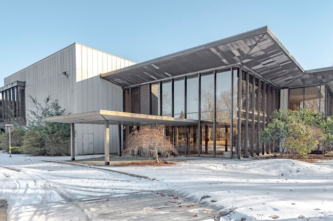
Property Record
199 Benson Rd, Middlebury, CT 06762
Property Detail
199 Benson Rd
MIDD-000802-000000-000006
Naugatuck Vly
Commercialnec
Connecticut
L200
6
C and X Area of minimal flood hazard, usually depicted on FIRMs as above the 500-year flood level.
40.53 AC
2025
Middlebury
2025
Westchester/So Connecticut
344200
New Haven, CT
NEARBY LISTINGS FOR SALE OR LEASE
DEMOGRAPHICS near 199 Benson Rd
1 mile
3 mile
5 mile
2025 Total Population
1,109
11,910
49,432
2030 Population
1,177
12,399
50,960
Pop Growth 2025-2030
+ 6.13%
+ 4.11%
+ 3.09%
Average Age
42
44
46
2025 Total Households
370
4,437
20,469
HH Growth 2025-2030
+ 5.95%
+ 4.01%
+ 2.99%
Median Household Inc
$119,359
$132,488
$102,378
Avg Household Size
2.70
2.60
2.40
2025 Avg HH Vehicles
3.00
2.00
2.00
Median Home Value
$540,576
$480,191
$405,357
Median Year Built
1995
1981
1975
Nearby Places
Map Layers
Map Styles
 Street
 Aerial
Layers
 Traffic
 Biking
Places
Listings with unknown addresses are not visible on the map
- Restaurants
- Banks
- Shops
- Fitness
- Groceries
PUBLIC TRANSPORTATION
COMMUTER RAIL
Naugatuck Station (New Haven Line - Metro-North Commuter Railroad Company (Metro-North))
Drive
Walk
Distance
Naugatuck Station (New Haven Line - Metro-North Commuter Railroad Company (Metro-North))
15 min
9.7 mi
AIRPORT
Tweed/New Haven
Drive
Walk
Distance
Tweed/New Haven
47 min
25.5 mi
Freight Ports
Port of New Haven
Drive
Walk
Distance
Port of New Haven
42 min
22.7 mi
SALE & LEASE HISTORY
LISTING DATE
SALE/LEASE

Sep 25, 2016
For Lease
Jun 06, 2017
For Lease
Jul 30, 2019
For Lease
Jul 26, 2019
For Sale
Feb 24, 2017
For Lease
Nearby Properties
Address
Land Use
TOTAL SIZE
Lot Size
Zoning
Address
Land Use
TOTAL SIZE
Lot Size
Zoning
404.50 AC
IND
Address
Land Use
TOTAL SIZE
Lot Size
Zoning
207,001 SF
60.66 AC
M-2
Address
Land Use
TOTAL SIZE
Lot Size
Zoning
23.58 AC
B-3A
Address
Land Use
TOTAL SIZE
Lot Size
Zoning
17.80 AC
IND
Address
Land Use
TOTAL SIZE
Lot Size
Zoning
20.30 AC
IND
Address
Land Use
TOTAL SIZE
Lot Size
Zoning
36.62 AC
L200
Address
Land Use
TOTAL SIZE
Lot Size
Zoning
137,519 SF
10.11 AC
IND
Address
Land Use
TOTAL SIZE
Lot Size
Zoning
3,744 SF
23.33 AC
OS60
Address
Land Use
TOTAL SIZE
Lot Size
Zoning
1,832 SF
77.04 AC
L200
Address
Land Use
TOTAL SIZE
Lot Size
Zoning
48,796 SF
13.53 AC
PDD
Address
Land Use
TOTAL SIZE
Lot Size
Zoning
20 AC
IND
Address
Land Use
TOTAL SIZE
Lot Size
Zoning
62.31 AC
IND
Address
Land Use
TOTAL SIZE
Lot Size
Zoning
110,160 SF
24.13 AC
IND
Address
Land Use
TOTAL SIZE
Lot Size
Zoning
142,146 SF
6.63 AC
B-2
Address
Land Use
TOTAL SIZE
Lot Size
Zoning
60,528 SF
10 AC
IND
Address
Land Use
TOTAL SIZE
Lot Size
Zoning
68,970 SF
10.50 AC
R-60
Address
Land Use
TOTAL SIZE
Lot Size
Zoning
32,264 SF
15.92 AC
R-60
Address
Land Use
TOTAL SIZE
Lot Size
Zoning
9.66 AC
IND
Address
Land Use
TOTAL SIZE
Lot Size
Zoning
60,000 SF
12 AC
IND
Address
Land Use
TOTAL SIZE
Lot Size
Zoning
43,250 SF
6.20 AC
IND
Address
Land Use
TOTAL SIZE
Lot Size
Zoning
45,000 SF
5.36 AC
IND
Address
Land Use
TOTAL SIZE
Lot Size
Zoning
51,345 SF
6.75 AC
IND
Address
Land Use
TOTAL SIZE
Lot Size
Zoning
67,910 SF
5.60 AC
IND
Address
Land Use
TOTAL SIZE
Lot Size
Zoning
18,685 SF
9.05 AC
CA40
Address
Land Use
TOTAL SIZE
Lot Size
Zoning
19.53 AC
Address
Land Use
TOTAL SIZE
Lot Size
Zoning
50,937 SF
7.25 AC
GI40
Address
Land Use
TOTAL SIZE
Lot Size
Zoning
35,820 SF
12 AC
IND
Address
Land Use
TOTAL SIZE
Lot Size
Zoning
41,200 SF
5.65 AC
IND
Address
Land Use
TOTAL SIZE
Lot Size
Zoning
44,000 SF
4.21 AC
IND
The World's #1 Commercial Real Estate Marketplace
Connect with us
© 2026 CoStar Group
The information above has been obtained from sources believed reliable. While we do not doubt its accuracy we have not verified it and make no guarantee, warranty or representation about it. It is your responsibility to independently confirm its accuracy and completeness. Any projections, opinions, assumptions, or estimates used are for example only and do not represent the current or future performance of the property. The value of this transaction to you depends on tax and other factors which should be evaluated by your tax, financial, and legal advisors. You and your advisors should conduct a careful, independent investigation of the property to determine to your satisfaction the suitability of the property for your needs.