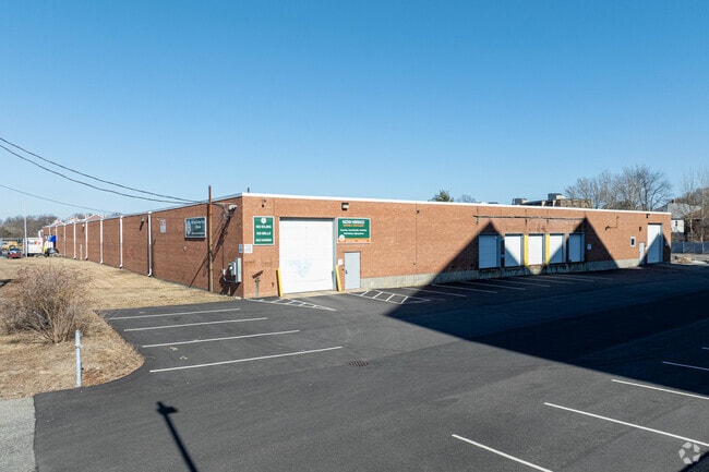
Property Record
199 Commander Shea Blvd, Quincy, MA 02171

Current Lease Availabilities
NEARBY LISTINGS FOR SALE OR LEASE
Property Detail
199 Commander Shea Blvd
QUIN-006076-000037-000010
Norfolk
Commercialbuilding
Massachusetts
AE
10
25025C0091J
3.29 AC
2025
Quincy/Braintree
2025
Boston
417300
Boston-Cambridge-Newton, MA-NH
67,932 SF
DEMOGRAPHICS near 199 Commander Shea Blvd
1 Mile
3 Mile
5 Mile
2024 Total Population
20,089
185,595
507,159
2029 Population
19,700
178,044
487,600
Pop Growth 2024-2029
(1.94%)
(4.07%)
(3.86%)
Average Age
42
39
39
2024 Total Households
8,889
71,025
203,472
HH Growth 2024-2029
(2.04%)
(4.23%)
(4.11%)
Median Household Inc
$102,207
$79,548
$82,308
Avg Household Size
2.20
2.50
2.30
2024 Avg HH Vehicles
1.00
1.00
1.00
Median Home Value
$643,837
$662,072
$686,450
Median Year Built
1962
1948
1951
Nearby Places
Map Layers
Map Styles
 Street
 Aerial
- Restaurants
- Banks
- Shops
- Fitness
- Groceries
PUBLIC TRANSPORTATION
COMMUTER RAIL
Quincy Center Station (Red Line - Massachusetts Bay Transportation Authority Subway (The T))
DRIVE
WALK
Distance
Quincy Center Station (Red Line - Massachusetts Bay Transportation Authority Subway (The T))
8 min
3.0 mi
Morton Street (Fairmount Line - Massachusetts Bay Transportation Authority Commuter Rail (Purple Line))
DRIVE
WALK
Distance
Morton Street (Fairmount Line - Massachusetts Bay Transportation Authority Commuter Rail (Purple Line))
6 min
3.4 mi
AIRPORT
General Edward Lawrence Logan International
DRIVE
WALK
Distance
General Edward Lawrence Logan International
17 min
8.9 mi
Nearby Properties
Address
Land Use
TOTAL SIZE
Lot Size
Zoning
Address
Land Use
TOTAL SIZE
Lot Size
Zoning
259,990 SF
2.84 AC
E
Address
Land Use
TOTAL SIZE
Lot Size
Zoning
148,456 SF
0.43 AC
Address
Land Use
TOTAL SIZE
Lot Size
Zoning
17.33 AC
Address
Land Use
TOTAL SIZE
Lot Size
Zoning
251,272 SF
3.77 AC
BUSC
Address
Land Use
TOTAL SIZE
Lot Size
Zoning
152,495 SF
6.51 AC
Address
Land Use
TOTAL SIZE
Lot Size
Zoning
254,856 SF
4.05 AC
BUSC
Address
Land Use
TOTAL SIZE
Lot Size
Zoning
3.31 AC
BUSC
Address
Land Use
TOTAL SIZE
Lot Size
Zoning
236,154 SF
1.41 AC
BUSC
Address
Land Use
TOTAL SIZE
Lot Size
Zoning
14.81 AC
Address
Land Use
TOTAL SIZE
Lot Size
Zoning
255,257 SF
2.34 AC
A
Address
Land Use
TOTAL SIZE
Lot Size
Zoning
681,518 SF
34.52 AC
Address
Land Use
TOTAL SIZE
Lot Size
Zoning
728,348 SF
11.71 AC
C
Address
Land Use
TOTAL SIZE
Lot Size
Zoning
526,040 SF
27.79 AC
E
Address
Land Use
TOTAL SIZE
Lot Size
Zoning
383,811 SF
5.86 AC
RESB
Address
Land Use
TOTAL SIZE
Lot Size
Zoning
5.06 AC
BUSC
Address
Land Use
TOTAL SIZE
Lot Size
Zoning
132,321 SF
3.94 AC
RC
Address
Land Use
TOTAL SIZE
Lot Size
Zoning
173,630 SF
4.46 AC
E
Address
Land Use
TOTAL SIZE
Lot Size
Zoning
17.85 AC
BUSC
Address
Land Use
TOTAL SIZE
Lot Size
Zoning
150,987 SF
6.90 AC
PUD
Address
Land Use
TOTAL SIZE
Lot Size
Zoning
132,997 SF
1.45 AC
Address
Land Use
TOTAL SIZE
Lot Size
Zoning
201,924 SF
2.17 AC
RC
Address
Land Use
TOTAL SIZE
Lot Size
Zoning
560,065 SF
28.20 AC
Address
Land Use
TOTAL SIZE
Lot Size
Zoning
147,611 SF
0.62 AC
BUSC
Address
Land Use
TOTAL SIZE
Lot Size
Zoning
275,752 SF
39.06 AC
E
Address
Land Use
TOTAL SIZE
Lot Size
Zoning
133,254 SF
4.21 AC
Address
Land Use
TOTAL SIZE
Lot Size
Zoning
167,236 SF
13.61 AC
C
Address
Land Use
TOTAL SIZE
Lot Size
Zoning
247,316 SF
2.75 AC
E
Address
Land Use
TOTAL SIZE
Lot Size
Zoning
124,274 SF
0.62 AC
Address
Land Use
TOTAL SIZE
Lot Size
Zoning
10.38 AC
Address
Land Use
TOTAL SIZE
Lot Size
Zoning
24,156 SF
7.65 AC
RESB
The World's #1 Commercial Real Estate Marketplace
Connect with us
© 2025 CoStar Group
The information above has been obtained from sources believed reliable. While we do not doubt its accuracy we have not verified it and make no guarantee, warranty or representation about it. It is your responsibility to independently confirm its accuracy and completeness. Any projections, opinions, assumptions, or estimates used are for example only and do not represent the current or future performance of the property. The value of this transaction to you depends on tax and other factors which should be evaluated by your tax, financial, and legal advisors. You and your advisors should conduct a careful, independent investigation of the property to determine to your satisfaction the suitability of the property for your needs.