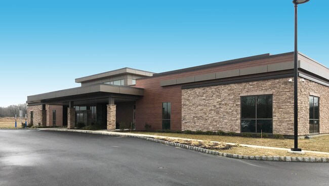
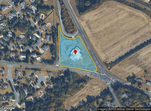
Property Record
199 Mullica Hill Rd, Mullica Hill, NJ 08062
NEARBY LISTINGS FOR SALE OR LEASE
Property Detail
199 Mullica Hill Rd
08-00034-03-00043
Gloucester
Vacantlandnec
New Jersey
X
43
34015C0177E
3.26 AC
2024
Gloucester County
2025
Philadelphia
502002
Philadelphia-Camden-Wilmington, PA-NJ-DE-MD
DEMOGRAPHICS near 199 Mullica Hill Rd
1 Mile
3 Mile
5 Mile
2024 Total Population
3,572
17,139
63,970
2029 Population
3,668
17,607
66,009
Pop Growth 2024-2029
+ 2.69%
+ 2.73%
+ 3.19%
Average Age
41
39
41
2024 Total Households
1,295
5,642
23,260
HH Growth 2024-2029
+ 2.70%
+ 2.75%
+ 3.28%
Median Household Inc
$122,840
$147,893
$114,198
Avg Household Size
2.70
3.00
2.70
2024 Avg HH Vehicles
2.00
2.00
2.00
Median Home Value
$421,533
$438,342
$339,102
Median Year Built
1992
1993
1985
Nearby Places
Map Layers
Map Styles
 Street
 Aerial
- Restaurants
- Banks
- Shops
- Fitness
- Groceries
PUBLIC TRANSPORTATION
AIRPORT
Philadelphia International
DRIVE
WALK
Distance
Philadelphia International
38 min
22.0 mi
Atlantic City International
DRIVE
WALK
Distance
Atlantic City International
82 min
46.7 mi
Freight Ports
Broadway Terminal - Pier 5
DRIVE
WALK
Distance
Broadway Terminal - Pier 5
26 min
16.1 mi
SALE & LEASE HISTORY
LISTING DATE
SALE/LEASE

Jan 30, 2019
For Lease
Nearby Properties
Address
Land Use
TOTAL SIZE
Lot Size
Zoning
Address
Land Use
TOTAL SIZE
Lot Size
Zoning
80.26 AC
INS
Address
Land Use
TOTAL SIZE
Lot Size
Zoning
13.76 AC
INS
Address
Land Use
TOTAL SIZE
Lot Size
Zoning
24.79 AC
R1
Address
Land Use
TOTAL SIZE
Lot Size
Zoning
Address
Land Use
TOTAL SIZE
Lot Size
Zoning
5,893 SF
12.79 AC
INSH
Address
Land Use
TOTAL SIZE
Lot Size
Zoning
7.85 AC
R12
Address
Land Use
TOTAL SIZE
Lot Size
Zoning
13.20 AC
INS
Address
Land Use
TOTAL SIZE
Lot Size
Zoning
3.79 AC
PRC
Address
Land Use
TOTAL SIZE
Lot Size
Zoning
5.15 AC
C1
Address
Land Use
TOTAL SIZE
Lot Size
Zoning
3.90 AC
INS
Address
Land Use
TOTAL SIZE
Lot Size
Zoning
19.15 AC
INS
Address
Land Use
TOTAL SIZE
Lot Size
Zoning
23.26 AC
LI
Address
Land Use
TOTAL SIZE
Lot Size
Zoning
Address
Land Use
TOTAL SIZE
Lot Size
Zoning
5 AC
AR
Address
Land Use
TOTAL SIZE
Lot Size
Zoning
177.74 AC
AR
Address
Land Use
TOTAL SIZE
Lot Size
Zoning
8 AC
C2
Address
Land Use
TOTAL SIZE
Lot Size
Zoning
7.28 AC
Address
Land Use
TOTAL SIZE
Lot Size
Zoning
4.73 AC
R1
Address
Land Use
TOTAL SIZE
Lot Size
Zoning
5.41 AC
LI
Address
Land Use
TOTAL SIZE
Lot Size
Zoning
2,984 SF
5.27 AC
R1
Address
Land Use
TOTAL SIZE
Lot Size
Zoning
9.59 AC
INS
Address
Land Use
TOTAL SIZE
Lot Size
Zoning
5.39 AC
C2
Address
Land Use
TOTAL SIZE
Lot Size
Zoning
14,889 SF
2.80 AC
C1
Address
Land Use
TOTAL SIZE
Lot Size
Zoning
6.66 AC
LI
Address
Land Use
TOTAL SIZE
Lot Size
Zoning
3.38 AC
C55
Address
Land Use
TOTAL SIZE
Lot Size
Zoning
6.16 AC
AR
Address
Land Use
TOTAL SIZE
Lot Size
Zoning
0.57 AC
C2
Address
Land Use
TOTAL SIZE
Lot Size
Zoning
3.70 AC
LI
Address
Land Use
TOTAL SIZE
Lot Size
Zoning
3.34 AC
LI
Address
Land Use
TOTAL SIZE
Lot Size
Zoning
15.76 AC
LI
The World's #1 Commercial Real Estate Marketplace
Connect with us
© 2025 CoStar Group
The information above has been obtained from sources believed reliable. While we do not doubt its accuracy we have not verified it and make no guarantee, warranty or representation about it. It is your responsibility to independently confirm its accuracy and completeness. Any projections, opinions, assumptions, or estimates used are for example only and do not represent the current or future performance of the property. The value of this transaction to you depends on tax and other factors which should be evaluated by your tax, financial, and legal advisors. You and your advisors should conduct a careful, independent investigation of the property to determine to your satisfaction the suitability of the property for your needs.