Property Record
199 S Addison Rd, Wood Dale, IL 60191


Current Lease Availabilities
NEARBY LISTINGS FOR SALE OR LEASE
Property Detail
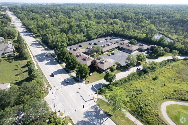
199 S Addison Rd
Chicago-Naperville-Elgin, IL-IN-WI
Brookwood Plaza
03-16-401-007
BROOKWOOD PLAZA OFFICE COMPLEX ALL /EX FOREST PRESERVE DIST/HALEAS ASSMT PLAT/
Commercialnec
DuPage
AE
Illinois
17043C0078J
2
2024
3.38 AC
2024
North DuPage
840104
Chicago
27,936 SF
DEMOGRAPHICS near 199 S Addison Rd
1 Mile
3 Mile
5 Mile
2024 Total Population
10,355
78,288
212,668
2029 Population
10,087
76,276
207,507
Pop Growth 2024-2029
(2.59%)
(2.57%)
(2.43%)
Average Age
42
40
41
2024 Total Households
3,816
27,524
78,005
HH Growth 2024-2029
(2.80%)
(2.77%)
(2.59%)
Median Household Inc
$84,968
$80,861
$84,663
Avg Household Size
2.70
2.70
2.60
2024 Avg HH Vehicles
2.00
2.00
2.00
Median Home Value
$275,178
$290,724
$295,110
Median Year Built
1969
1970
1970
Nearby Places
Map Layers
Map Styles
 Street
 Aerial
- Restaurants
- Banks
- Shops
- Fitness
- Groceries
PUBLIC TRANSPORTATION
COMMUTER RAIL
Wood Dale Station (Milwaukee District West Line - Northeast Illinois Regional Commuter Railroad (Metra))
DRIVE
WALK
Distance
Wood Dale Station (Milwaukee District West Line - Northeast Illinois Regional Commuter Railroad (Metra))
4 min
1.4 mi
Itasca Station (Milwaukee District West Line - Northeast Illinois Regional Commuter Railroad (Metra))
DRIVE
WALK
Distance
Itasca Station (Milwaukee District West Line - Northeast Illinois Regional Commuter Railroad (Metra))
6 min
2.3 mi
Nearby Properties
Address
Land Use
TOTAL SIZE
Lot Size
Zoning
Address
Land Use
TOTAL SIZE
Lot Size
Zoning
189,290 SF
9.51 AC
Address
Land Use
TOTAL SIZE
Lot Size
Zoning
18.91 AC
Address
Land Use
TOTAL SIZE
Lot Size
Zoning
Address
Land Use
TOTAL SIZE
Lot Size
Zoning
17.67 AC
Address
Land Use
TOTAL SIZE
Lot Size
Zoning
17.73 AC
Address
Land Use
TOTAL SIZE
Lot Size
Zoning
14.76 AC
Address
Land Use
TOTAL SIZE
Lot Size
Zoning
525,422 SF
8.45 AC
C
Address
Land Use
TOTAL SIZE
Lot Size
Zoning
15.32 AC
Address
Land Use
TOTAL SIZE
Lot Size
Zoning
487,027 SF
8.36 AC
C
Address
Land Use
TOTAL SIZE
Lot Size
Zoning
15.29 AC
Address
Land Use
TOTAL SIZE
Lot Size
Zoning
14.35 AC
Address
Land Use
TOTAL SIZE
Lot Size
Zoning
450,614 SF
17.97 AC
C
Address
Land Use
TOTAL SIZE
Lot Size
Zoning
469,492 SF
14.87 AC
I
Address
Land Use
TOTAL SIZE
Lot Size
Zoning
14.37 AC
I
Address
Land Use
TOTAL SIZE
Lot Size
Zoning
Address
Land Use
TOTAL SIZE
Lot Size
Zoning
441,232 SF
34.52 AC
I
Address
Land Use
TOTAL SIZE
Lot Size
Zoning
338,816 SF
16.84 AC
I
Address
Land Use
TOTAL SIZE
Lot Size
Zoning
288,000 SF
11.05 AC
C
Address
Land Use
TOTAL SIZE
Lot Size
Zoning
193,020 SF
8.94 AC
I
Address
Land Use
TOTAL SIZE
Lot Size
Zoning
309,864 SF
37.33 AC
I
Address
Land Use
TOTAL SIZE
Lot Size
Zoning
139,923 SF
11.98 AC
I
Address
Land Use
TOTAL SIZE
Lot Size
Zoning
136,975 SF
1.90 AC
Address
Land Use
TOTAL SIZE
Lot Size
Zoning
186,486 SF
2.43 AC
A
Address
Land Use
TOTAL SIZE
Lot Size
Zoning
249,304 SF
15.28 AC
I
Address
Land Use
TOTAL SIZE
Lot Size
Zoning
256,686 SF
10.60 AC
I
Address
Land Use
TOTAL SIZE
Lot Size
Zoning
15.33 AC
M
Address
Land Use
TOTAL SIZE
Lot Size
Zoning
10.60 AC
Address
Land Use
TOTAL SIZE
Lot Size
Zoning
9.59 AC
Address
Land Use
TOTAL SIZE
Lot Size
Zoning
139,672 SF
15.41 AC
I
Address
Land Use
TOTAL SIZE
Lot Size
Zoning
269,260 SF
10.61 AC
I
The World's #1 Commercial Real Estate Marketplace
Connect with us
© 2026 CoStar Group
The information above has been obtained from sources believed reliable. While we do not doubt its accuracy we have not verified it and make no guarantee, warranty or representation about it. It is your responsibility to independently confirm its accuracy and completeness. Any projections, opinions, assumptions, or estimates used are for example only and do not represent the current or future performance of the property. The value of this transaction to you depends on tax and other factors which should be evaluated by your tax, financial, and legal advisors. You and your advisors should conduct a careful, independent investigation of the property to determine to your satisfaction the suitability of the property for your needs.