Property Record
199 S Cherry St, Cherryville, NC 28021
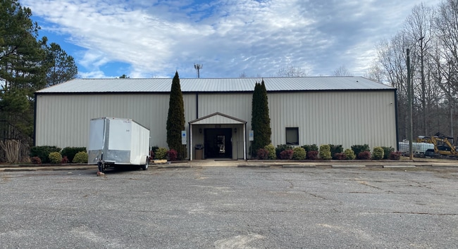

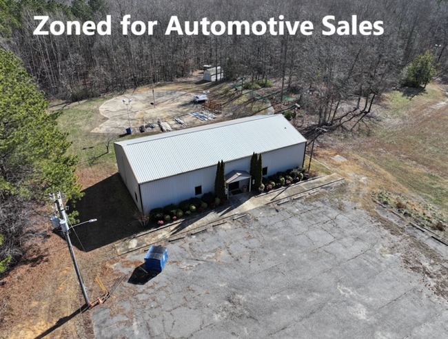
This Property Is For Sale
Property Detail
199 S Cherry St
131184
06 016A 012 04 000
Commercialofficeresidentialmixeduse
Gaston
STOR1
North Carolina
AE The base floodplain where base flood elevations are provided. AE Zones are now used on new format FIRMs instead of A1-A30 Zones.
27.45 AC
2025
Gaston County
2025
Charlotte
030700
Charlotte-Concord-Gastonia, NC-SC
3,528 SF
NEARBY LISTINGS FOR SALE OR LEASE
DEMOGRAPHICS near 199 S Cherry St
1 mile
3 mile
5 mile
2024 Total Population
3,498
10,568
19,381
2029 Population
3,695
11,206
20,474
Pop Growth 2024-2029
+ 5.63%
+ 6.04%
+ 5.64%
Average Age
43
42
42
2024 Total Households
1,414
4,220
7,684
HH Growth 2024-2029
+ 5.87%
+ 6.26%
+ 5.83%
Median Household Inc
$64,898
$61,319
$61,365
Avg Household Size
2.40
2.40
2.40
2024 Avg HH Vehicles
2.00
2.00
2.00
Median Home Value
$259,203
$258,523
$263,414
Median Year Built
1975
1977
1982
Nearby Places
Map Layers
Map Styles
 Street
 Aerial
Transit
 Traffic
 Biking
Places
Listings with unknown addresses are not visible on the map
- Restaurants
- Banks
- Shops
- Fitness
- Groceries
PUBLIC TRANSPORTATION
AIRPORT
Charlotte/Douglas International
Drive
Walk
Distance
Charlotte/Douglas International
52 min
32.0 mi
Nearby Properties
Address
Land Use
TOTAL SIZE
Lot Size
Zoning
Address
Land Use
TOTAL SIZE
Lot Size
Zoning
151,003 SF
27.39 AC
SHOP5
Address
Land Use
TOTAL SIZE
Lot Size
Zoning
69,747 SF
18.33 AC
R1
Address
Land Use
TOTAL SIZE
Lot Size
Zoning
1,320 SF
72.60 AC
Address
Land Use
TOTAL SIZE
Lot Size
Zoning
92,928 SF
21.25 AC
PUB01
Address
Land Use
TOTAL SIZE
Lot Size
Zoning
38,904 SF
5.84 AC
HCAR4
Address
Land Use
TOTAL SIZE
Lot Size
Zoning
3,917 SF
3.43 AC
R2
Address
Land Use
TOTAL SIZE
Lot Size
Zoning
75,190 SF
10.69 AC
PUB01
Address
Land Use
TOTAL SIZE
Lot Size
Zoning
6,116 SF
52.31 AC
Address
Land Use
TOTAL SIZE
Lot Size
Zoning
1,574 SF
16.90 AC
Address
Land Use
TOTAL SIZE
Lot Size
Zoning
18,300 SF
8.61 AC
Address
Land Use
TOTAL SIZE
Lot Size
Zoning
62,238 SF
17 AC
PUB01
Address
Land Use
TOTAL SIZE
Lot Size
Zoning
6,480 SF
12.98 AC
PUB01
Address
Land Use
TOTAL SIZE
Lot Size
Zoning
41,067 SF
2.42 AC
CHUR2
Address
Land Use
TOTAL SIZE
Lot Size
Zoning
97,650 SF
11.66 AC
INDS2
Address
Land Use
TOTAL SIZE
Lot Size
Zoning
35,044 SF
5.88 AC
CHUR2
Address
Land Use
TOTAL SIZE
Lot Size
Zoning
38,154 SF
26.69 AC
CHUR2
Address
Land Use
TOTAL SIZE
Lot Size
Zoning
106,624 SF
8.38 AC
INDS1
Address
Land Use
TOTAL SIZE
Lot Size
Zoning
22,808 SF
2.67 AC
HCAR4
Address
Land Use
TOTAL SIZE
Lot Size
Zoning
46,361 SF
14.71 AC
STOR2
Address
Land Use
TOTAL SIZE
Lot Size
Zoning
6,975 SF
105.20 AC
R2
Address
Land Use
TOTAL SIZE
Lot Size
Zoning
45,862 SF
4.99 AC
SHOP1
Address
Land Use
TOTAL SIZE
Lot Size
Zoning
650 SF
4.33 AC
INDS1
Address
Land Use
TOTAL SIZE
Lot Size
Zoning
7,702 SF
1.55 AC
OFF01
Address
Land Use
TOTAL SIZE
Lot Size
Zoning
24,098 SF
9.67 AC
OFF01
Address
Land Use
TOTAL SIZE
Lot Size
Zoning
768 SF
11.52 AC
APT01
Address
Land Use
TOTAL SIZE
Lot Size
Zoning
38,536 SF
10.20 AC
OFF01
Address
Land Use
TOTAL SIZE
Lot Size
Zoning
512 SF
912.91 AC
R15
Address
Land Use
TOTAL SIZE
Lot Size
Zoning
26,004 SF
12.35 AC
CHUR2
Address
Land Use
TOTAL SIZE
Lot Size
Zoning
119,424 SF
11.57 AC
INDS2
Address
Land Use
TOTAL SIZE
Lot Size
Zoning
13,881 SF
2.48 AC
GOV06
The World's #1 Commercial Real Estate Marketplace
Connect with us
© 2026 CoStar Group
The information above has been obtained from sources believed reliable. While we do not doubt its accuracy we have not verified it and make no guarantee, warranty or representation about it. It is your responsibility to independently confirm its accuracy and completeness. Any projections, opinions, assumptions, or estimates used are for example only and do not represent the current or future performance of the property. The value of this transaction to you depends on tax and other factors which should be evaluated by your tax, financial, and legal advisors. You and your advisors should conduct a careful, independent investigation of the property to determine to your satisfaction the suitability of the property for your needs.