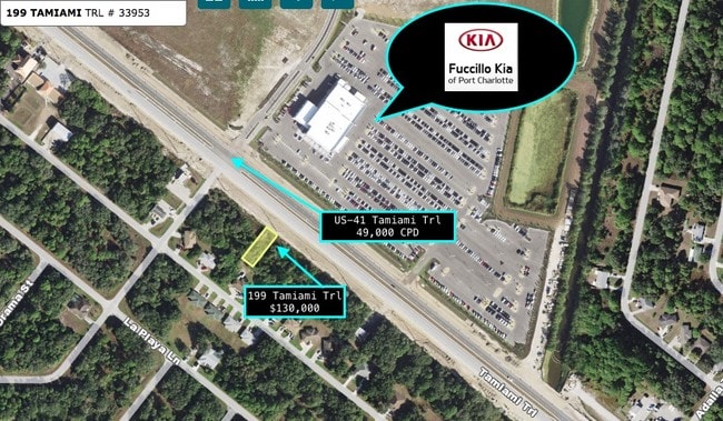
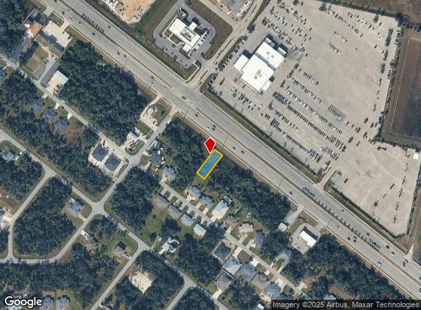
Property Record
199 Tamiami Trl, Port Charlotte, FL 33953
NEARBY LISTINGS FOR SALE OR LEASE
Property Detail
199 Tamiami Trl
Punta Gorda, FL
Port Charlotte
402103181021
PORT CHARLOTTE SEC32 BLK2446 LT 70 244/186 357/882 PR97-915 DC2228/1415-FBS TR AFF2245/12812 2171/1409 2271/1411 AFF3089/2054 NT3138/1902 3212/2157 TXD3851/1672 3940/1627 E4591/1996 3368791
Commercialacreage
Charlotte
X
Florida
12015C0040G
70
2024
0.17 AC
2025
Charlotte County
020402
Southwest Florida
DEMOGRAPHICS near 199 Tamiami Trl
1 Mile
3 Mile
5 Mile
2024 Total Population
3,830
30,613
85,773
2029 Population
4,483
35,362
99,486
Pop Growth 2024-2029
+ 17.05%
+ 15.51%
+ 15.99%
Average Age
45
47
47
2024 Total Households
1,516
12,716
35,784
HH Growth 2024-2029
+ 17.28%
+ 15.60%
+ 16.20%
Median Household Inc
$57,350
$61,478
$61,459
Avg Household Size
2.50
2.30
2.30
2024 Avg HH Vehicles
2.00
2.00
2.00
Median Home Value
$262,058
$244,306
$237,358
Median Year Built
1999
2001
1999
Nearby Places
- Restaurants
- Banks
- Shops
- Fitness
- Groceries
PUBLIC TRANSPORTATION
AIRPORT
Punta Gorda
DRIVE
WALK
Distance
Punta Gorda
29 min
15.9 mi
Freight Ports
Port Manatee
DRIVE
WALK
Distance
Port Manatee
73 min
56.1 mi
SALE & LEASE HISTORY
LISTING DATE
SALE/LEASE

Oct 28, 2024
For Sale
May 09, 2017
For Sale
Nearby Properties
Address
Land Use
TOTAL SIZE
Lot Size
Zoning
Address
Land Use
TOTAL SIZE
Lot Size
Zoning
316,994 SF
40.88 AC
V
Address
Land Use
TOTAL SIZE
Lot Size
Zoning
103,886 SF
21.48 AC
PD
Address
Land Use
TOTAL SIZE
Lot Size
Zoning
267,412 SF
23.26 AC
AC1
Address
Land Use
TOTAL SIZE
Lot Size
Zoning
132,969 SF
80.28 AC
PKR
Address
Land Use
TOTAL SIZE
Lot Size
Zoning
131,053 SF
14.40 AC
PD
Address
Land Use
TOTAL SIZE
Lot Size
Zoning
9,511 SF
40.53 AC
PD
Address
Land Use
TOTAL SIZE
Lot Size
Zoning
205,624 SF
21.37 AC
AC1
Address
Land Use
TOTAL SIZE
Lot Size
Zoning
94,423 SF
12.87 AC
V
Address
Land Use
TOTAL SIZE
Lot Size
Zoning
114,985 SF
29.77 AC
GU
Address
Land Use
TOTAL SIZE
Lot Size
Zoning
79,944 SF
15.64 AC
PCDN
Address
Land Use
TOTAL SIZE
Lot Size
Zoning
196,163 SF
15.60 AC
AC1
Address
Land Use
TOTAL SIZE
Lot Size
Zoning
95.20 AC
PD
Address
Land Use
TOTAL SIZE
Lot Size
Zoning
115,678 SF
8.58 AC
R3
Address
Land Use
TOTAL SIZE
Lot Size
Zoning
142,364 SF
13.87 AC
AC1
Address
Land Use
TOTAL SIZE
Lot Size
Zoning
37,567 SF
36.76 AC
PKR
Address
Land Use
TOTAL SIZE
Lot Size
Zoning
65,103 SF
10.16 AC
AC2
Address
Land Use
TOTAL SIZE
Lot Size
Zoning
85,529 SF
11.41 AC
CG
Address
Land Use
TOTAL SIZE
Lot Size
Zoning
105,046 SF
12.69 AC
AC1
Address
Land Use
TOTAL SIZE
Lot Size
Zoning
48,392 SF
3.89 AC
PD
Address
Land Use
TOTAL SIZE
Lot Size
Zoning
17.48 AC
AC1
Address
Land Use
TOTAL SIZE
Lot Size
Zoning
30,242 SF
7.40 AC
CG
Address
Land Use
TOTAL SIZE
Lot Size
Zoning
43,387 SF
5.09 AC
AC2
Address
Land Use
TOTAL SIZE
Lot Size
Zoning
42,923 SF
403.06 AC
PCDN
Address
Land Use
TOTAL SIZE
Lot Size
Zoning
40,467 SF
2.89 AC
CG
Address
Land Use
TOTAL SIZE
Lot Size
Zoning
22.07 AC
PD
Address
Land Use
TOTAL SIZE
Lot Size
Zoning
63,016 SF
2.56 AC
AC1
Address
Land Use
TOTAL SIZE
Lot Size
Zoning
12,670 SF
17.20 AC
CG
Address
Land Use
TOTAL SIZE
Lot Size
Zoning
31,470 SF
20.05 AC
PD
Address
Land Use
TOTAL SIZE
Lot Size
Zoning
29,760 SF
118.84 AC
PD
Address
Land Use
TOTAL SIZE
Lot Size
Zoning
109,239 SF
20 AC
RSF3.5
The World's #1 Commercial Real Estate Marketplace
Connect with us
© 2025 CoStar Group
The information above has been obtained from sources believed reliable. While we do not doubt its accuracy we have not verified it and make no guarantee, warranty or representation about it. It is your responsibility to independently confirm its accuracy and completeness. Any projections, opinions, assumptions, or estimates used are for example only and do not represent the current or future performance of the property. The value of this transaction to you depends on tax and other factors which should be evaluated by your tax, financial, and legal advisors. You and your advisors should conduct a careful, independent investigation of the property to determine to your satisfaction the suitability of the property for your needs.