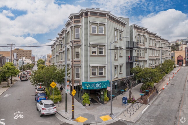
Property Record
199 Tiffany Ave, San Francisco, CA 94110
Current Lease Availabilities
NEARBY LISTINGS FOR SALE OR LEASE
Property Detail
199 Tiffany Ave
San Francisco
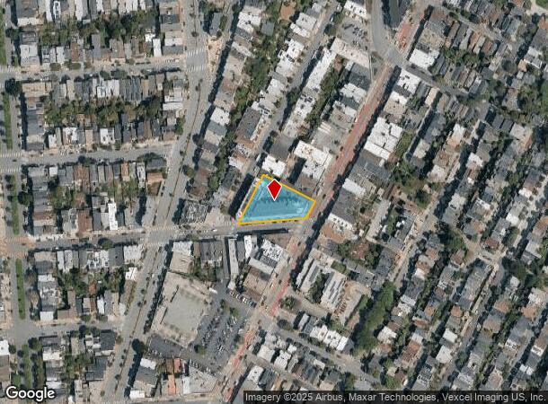
Map Of San Francisco Tiffany Gardens
San Francisco-Redwood City-South San Francisco, CA
San Francisco
6596-050
California
Condominium
0.59 AC
1,278 SF
Bernal Heights
DEMOGRAPHICS near 199 Tiffany Ave
1 Mile
3 Mile
5 Mile
2024 Total Population
70,805
484,986
848,666
2029 Population
65,787
447,434
785,712
Pop Growth 2024-2029
(7.09%)
(7.74%)
(7.42%)
Average Age
42
42
42
2024 Total Households
28,883
195,535
353,654
HH Growth 2024-2029
(7.62%)
(8.07%)
(7.76%)
Median Household Inc
$163,031
$122,613
$124,202
Avg Household Size
2.40
2.30
2.30
2024 Avg HH Vehicles
1.00
1.00
1.00
Median Home Value
$1,115,747
$1,088,038
$1,092,870
Median Year Built
1947
1950
1949
Nearby Places
Map Layers
Map Styles
 Street
 Aerial
- Restaurants
- Banks
- Shops
- Fitness
- Groceries
PUBLIC TRANSPORTATION
TRANSIT/SUBWAY
30th Street and Dolores (J Church - San Francisco Municipal Railway (MUNI Metro))
DRIVE
WALK
Distance
30th Street and Dolores (J Church - San Francisco Municipal Railway (MUNI Metro))
1 min
5 min
0.2 mi
Church and 29th Street (J Church - San Francisco Municipal Railway (MUNI Metro))
DRIVE
WALK
Distance
Church and 29th Street (J Church - San Francisco Municipal Railway (MUNI Metro))
1 min
6 min
0.3 mi
J Line Outbound (J Church - San Francisco Municipal Railway (MUNI Metro))
DRIVE
WALK
Distance
J Line Outbound (J Church - San Francisco Municipal Railway (MUNI Metro))
1 min
7 min
0.3 mi
Church and 27th Street (J Church - San Francisco Municipal Railway (MUNI Metro))
DRIVE
WALK
Distance
Church and 27th Street (J Church - San Francisco Municipal Railway (MUNI Metro))
2 min
10 min
0.5 mi
COMMUTER RAIL
DRIVE
WALK
Distance
8 min
3.3 mi
22nd Street (Caltrain - Caltrain (Caltrain))
DRIVE
WALK
Distance
22nd Street (Caltrain - Caltrain (Caltrain))
9 min
3.3 mi
AIRPORT
San Francisco International
DRIVE
WALK
Distance
San Francisco International
20 min
12.7 mi
Metro Oakland International
DRIVE
WALK
Distance
Metro Oakland International
37 min
22.7 mi
Norman Y Mineta San Jose International
DRIVE
WALK
Distance
Norman Y Mineta San Jose International
55 min
44.3 mi
Freight Ports
Port of San Francisco
DRIVE
WALK
Distance
Port of San Francisco
14 min
6.1 mi
Nearby Properties
Address
Land Use
TOTAL SIZE
Lot Size
Zoning
Address
Land Use
TOTAL SIZE
Lot Size
Zoning
1,015,000 SF
2.43 AC
RC4
Address
Land Use
TOTAL SIZE
Lot Size
Zoning
750,370 SF
3.25 AC
MBR3
Address
Land Use
TOTAL SIZE
Lot Size
Zoning
248,303 SF
4.35 AC
Address
Land Use
TOTAL SIZE
Lot Size
Zoning
717,234 SF
3.47 AC
UMU
Address
Land Use
TOTAL SIZE
Lot Size
Zoning
10.92 AC
Address
Land Use
TOTAL SIZE
Lot Size
Zoning
266,143 SF
4 AC
C-3-R
Address
Land Use
TOTAL SIZE
Lot Size
Zoning
885,581 SF
5.20 AC
M2
Address
Land Use
TOTAL SIZE
Lot Size
Zoning
696,431 SF
0.97 AC
C3G
Address
Land Use
TOTAL SIZE
Lot Size
Zoning
1.52 AC
C3G
Address
Land Use
TOTAL SIZE
Lot Size
Zoning
1,424,230 SF
2.60 AC
C3G
Address
Land Use
TOTAL SIZE
Lot Size
Zoning
2.74 AC
Address
Land Use
TOTAL SIZE
Lot Size
Zoning
313,306 SF
1.23 AC
WMUG
Address
Land Use
TOTAL SIZE
Lot Size
Zoning
314,826 SF
1.85 AC
MB-RA
Address
Land Use
TOTAL SIZE
Lot Size
Zoning
10.92 AC
Address
Land Use
TOTAL SIZE
Lot Size
Zoning
393,918 SF
3.36 AC
WMUG
Address
Land Use
TOTAL SIZE
Lot Size
Zoning
24.37 AC
Address
Land Use
TOTAL SIZE
Lot Size
Zoning
241,659 SF
3.76 AC
Address
Land Use
TOTAL SIZE
Lot Size
Zoning
230,853 SF
3.76 AC
Address
Land Use
TOTAL SIZE
Lot Size
Zoning
302,084 SF
0.88 AC
MBO
Address
Land Use
TOTAL SIZE
Lot Size
Zoning
674,317 SF
3.36 AC
UMU
Address
Land Use
TOTAL SIZE
Lot Size
Zoning
319,119 SF
0.76 AC
Address
Land Use
TOTAL SIZE
Lot Size
Zoning
649,376 SF
0.93 AC
C3S
Address
Land Use
TOTAL SIZE
Lot Size
Zoning
222,000 SF
1 AC
MB-RA
Address
Land Use
TOTAL SIZE
Lot Size
Zoning
10.92 AC
Address
Land Use
TOTAL SIZE
Lot Size
Zoning
2.93 AC
Address
Land Use
TOTAL SIZE
Lot Size
Zoning
342,727 SF
1.36 AC
C3G
Address
Land Use
TOTAL SIZE
Lot Size
Zoning
291,522 SF
6.66 AC
CM
Address
Land Use
TOTAL SIZE
Lot Size
Zoning
250,884 SF
1.66 AC
MB-RA
Address
Land Use
TOTAL SIZE
Lot Size
Zoning
718 SF
18.55 AC
RH2
Address
Land Use
TOTAL SIZE
Lot Size
Zoning
375,030 SF
0.96 AC
The World's #1 Commercial Real Estate Marketplace
Connect with us
© 2025 CoStar Group
The information above has been obtained from sources believed reliable. While we do not doubt its accuracy we have not verified it and make no guarantee, warranty or representation about it. It is your responsibility to independently confirm its accuracy and completeness. Any projections, opinions, assumptions, or estimates used are for example only and do not represent the current or future performance of the property. The value of this transaction to you depends on tax and other factors which should be evaluated by your tax, financial, and legal advisors. You and your advisors should conduct a careful, independent investigation of the property to determine to your satisfaction the suitability of the property for your needs.