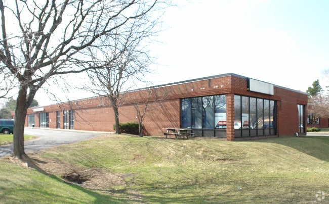
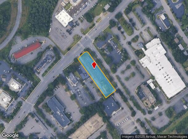
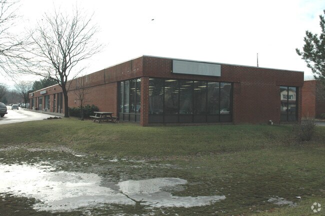
Property Record
199 Wolf Rd, Albany, NY 12205
NEARBY LISTINGS FOR SALE OR LEASE
Property Detail
199 Wolf Rd
012689-030-004-0001-055-004-0000
N-WOLF RD E-MARCUS BLVD C-99-09
Storesoffices
Albany
X
New York
36001C0181D
55.004
2025
1.10 AC
2024
E Outer Albany County
013708
Albany/Schenectady/Troy
12,500 SF
Albany-Schenectady-Troy, NY
DEMOGRAPHICS near 199 Wolf Rd
1 Mile
3 Mile
5 Mile
2024 Total Population
3,778
46,457
172,460
2029 Population
3,729
46,022
170,792
Pop Growth 2024-2029
(1.30%)
(0.94%)
(0.97%)
Average Age
47
43
40
2024 Total Households
1,816
18,995
70,132
HH Growth 2024-2029
(1.27%)
(1.02%)
(1.07%)
Median Household Inc
$79,191
$89,610
$74,433
Avg Household Size
2.10
2.30
2.20
2024 Avg HH Vehicles
2.00
2.00
2.00
Median Home Value
$324,116
$270,159
$261,716
Median Year Built
1977
1966
1964
Nearby Places
- Restaurants
- Banks
- Shops
- Fitness
- Groceries
PUBLIC TRANSPORTATION
COMMUTER RAIL
DRIVE
WALK
Distance
20 min
9.0 mi
AIRPORT
Albany International
DRIVE
WALK
Distance
Albany International
8 min
3.6 mi
SALE & LEASE HISTORY
LISTING DATE
SALE/LEASE

Sep 25, 2016
For Lease
Mar 01, 2019
For Lease
Jul 06, 2020
For Lease
Jan 09, 2017
For Lease
Nearby Properties
Address
Land Use
TOTAL SIZE
Lot Size
Zoning
Address
Land Use
TOTAL SIZE
Lot Size
Zoning
72,000 SF
279.23 AC
CO
Address
Land Use
TOTAL SIZE
Lot Size
Zoning
5.04 AC
CM
Address
Land Use
TOTAL SIZE
Lot Size
Zoning
Address
Land Use
TOTAL SIZE
Lot Size
Zoning
821,670 SF
803.50 AC
17
Address
Land Use
TOTAL SIZE
Lot Size
Zoning
18,340 SF
159.79 AC
04 - FARM
Address
Land Use
TOTAL SIZE
Lot Size
Zoning
10,216 SF
48.37 AC
16
Address
Land Use
TOTAL SIZE
Lot Size
Zoning
595,472 SF
6.06 AC
CO
Address
Land Use
TOTAL SIZE
Lot Size
Zoning
154,580 SF
89.34 AC
16
Address
Land Use
TOTAL SIZE
Lot Size
Zoning
12,096 SF
73.12 AC
CM
Address
Land Use
TOTAL SIZE
Lot Size
Zoning
373,296 SF
11.70 AC
46
Address
Land Use
TOTAL SIZE
Lot Size
Zoning
365,400 SF
73.90 AC
04 - FARM
Address
Land Use
TOTAL SIZE
Lot Size
Zoning
226,171 SF
26.39 AC
12
Address
Land Use
TOTAL SIZE
Lot Size
Zoning
301,834 SF
9 AC
26
Address
Land Use
TOTAL SIZE
Lot Size
Zoning
266,600 SF
22.60 AC
47
Address
Land Use
TOTAL SIZE
Lot Size
Zoning
84,242 SF
43.60 AC
12
Address
Land Use
TOTAL SIZE
Lot Size
Zoning
25,786 SF
8 AC
17
Address
Land Use
TOTAL SIZE
Lot Size
Zoning
167,222 SF
15.65 AC
14
Address
Land Use
TOTAL SIZE
Lot Size
Zoning
87.50 AC
CO
Address
Land Use
TOTAL SIZE
Lot Size
Zoning
10,500 SF
40.10 AC
CO
Address
Land Use
TOTAL SIZE
Lot Size
Zoning
77.50 AC
M1
Address
Land Use
TOTAL SIZE
Lot Size
Zoning
162,500 SF
19.90 AC
17
Address
Land Use
TOTAL SIZE
Lot Size
Zoning
256,101 SF
9 AC
12
Address
Land Use
TOTAL SIZE
Lot Size
Zoning
150,000 SF
1 AC
CM
Address
Land Use
TOTAL SIZE
Lot Size
Zoning
141,570 SF
4.43 AC
12
Address
Land Use
TOTAL SIZE
Lot Size
Zoning
59,239 SF
1.95 AC
R1A
Address
Land Use
TOTAL SIZE
Lot Size
Zoning
59,239 SF
2.06 AC
R1A
Address
Land Use
TOTAL SIZE
Lot Size
Zoning
143,885 SF
4.13 AC
C2
Address
Land Use
TOTAL SIZE
Lot Size
Zoning
51,540 SF
2.85 AC
C2
Address
Land Use
TOTAL SIZE
Lot Size
Zoning
238,709 SF
55.82 AC
04 - FARM
Address
Land Use
TOTAL SIZE
Lot Size
Zoning
83,120 SF
126.75 AC
25
The World's #1 Commercial Real Estate Marketplace
Connect with us
© 2025 CoStar Group
The information above has been obtained from sources believed reliable. While we do not doubt its accuracy we have not verified it and make no guarantee, warranty or representation about it. It is your responsibility to independently confirm its accuracy and completeness. Any projections, opinions, assumptions, or estimates used are for example only and do not represent the current or future performance of the property. The value of this transaction to you depends on tax and other factors which should be evaluated by your tax, financial, and legal advisors. You and your advisors should conduct a careful, independent investigation of the property to determine to your satisfaction the suitability of the property for your needs.