Property Record
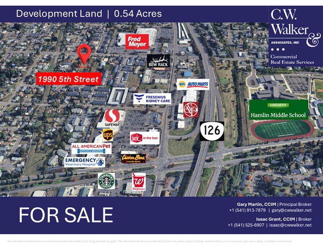
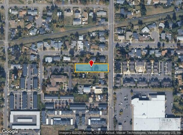
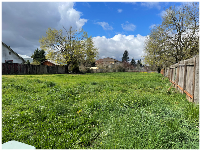
1990 5Th St, Springfield, OR 97477
NEARBY LISTINGS FOR SALE OR LEASE
Property Detail
1990 5Th St
Eugene-Springfield, OR
TL 03300
0218980
Lane
Residentialacreage
Oregon
X
3300
41039C1134F
0.54 AC
2025
Lane County
2025
Portland
002101
DEMOGRAPHICS near 1990 5Th St
1 Mile
3 Mile
5 Mile
2024 Total Population
16,599
72,976
163,018
2029 Population
16,502
73,064
163,895
Pop Growth 2024-2029
(0.58%)
+ 0.12%
+ 0.54%
Average Age
39
39
39
2024 Total Households
6,872
29,297
69,281
HH Growth 2024-2029
(0.67%)
+ 0.06%
+ 0.50%
Median Household Inc
$53,450
$57,003
$57,384
Avg Household Size
2.40
2.30
2.20
2024 Avg HH Vehicles
2.00
2.00
2.00
Median Home Value
$298,880
$347,295
$382,332
Median Year Built
1969
1975
1976
Nearby Places
Map Layers
Map Styles
 Street
 Aerial
- Restaurants
- Banks
- Shops
- Fitness
- Groceries
PUBLIC TRANSPORTATION
COMMUTER RAIL
Eugene (Amtrak Cascades - Amtrak, Coast Starlight - Amtrak)
DRIVE
WALK
Distance
Eugene (Amtrak Cascades - Amtrak, Coast Starlight - Amtrak)
8 min
4.4 mi
AIRPORT
Mahlon Sweet Field
DRIVE
WALK
Distance
Mahlon Sweet Field
21 min
12.4 mi
Freight Ports
Port of Coos Bay, OR
DRIVE
WALK
Distance
Port of Coos Bay, OR
158 min
112.8 mi
SALE & LEASE HISTORY
LISTING DATE
SALE/LEASE

Apr 03, 2025
For Sale
Nearby Properties
Address
Land Use
TOTAL SIZE
Lot Size
Zoning
Address
Land Use
TOTAL SIZE
Lot Size
Zoning
15.37 AC
PL
Address
Land Use
TOTAL SIZE
Lot Size
Zoning
71.87 AC
PL
Address
Land Use
TOTAL SIZE
Lot Size
Zoning
1.56 AC
C-2
Address
Land Use
TOTAL SIZE
Lot Size
Zoning
1.86 AC
C-2
Address
Land Use
TOTAL SIZE
Lot Size
Zoning
9.57 AC
LD
Address
Land Use
TOTAL SIZE
Lot Size
Zoning
24 AC
C-2
Address
Land Use
TOTAL SIZE
Lot Size
Zoning
13.82 AC
PL
Address
Land Use
TOTAL SIZE
Lot Size
Zoning
9.81 AC
C-2
Address
Land Use
TOTAL SIZE
Lot Size
Zoning
3.10 AC
S-WS
Address
Land Use
TOTAL SIZE
Lot Size
Zoning
33.20 AC
HI
Address
Land Use
TOTAL SIZE
Lot Size
Zoning
22.52 AC
LD
Address
Land Use
TOTAL SIZE
Lot Size
Zoning
16.80 AC
PL
Address
Land Use
TOTAL SIZE
Lot Size
Zoning
14.39 AC
E-1
Address
Land Use
TOTAL SIZE
Lot Size
Zoning
3.29 AC
S-RP
Address
Land Use
TOTAL SIZE
Lot Size
Zoning
Address
Land Use
TOTAL SIZE
Lot Size
Zoning
9.59 AC
R-1
Address
Land Use
TOTAL SIZE
Lot Size
Zoning
14.54 AC
C-2
Address
Land Use
TOTAL SIZE
Lot Size
Zoning
2.15 AC
PL
Address
Land Use
TOTAL SIZE
Lot Size
Zoning
Address
Land Use
TOTAL SIZE
Lot Size
Zoning
17.37 AC
AG
Address
Land Use
TOTAL SIZE
Lot Size
Zoning
13.55 AC
CI
Address
Land Use
TOTAL SIZE
Lot Size
Zoning
11.23 AC
Address
Land Use
TOTAL SIZE
Lot Size
Zoning
Address
Land Use
TOTAL SIZE
Lot Size
Zoning
Address
Land Use
TOTAL SIZE
Lot Size
Zoning
14.09 AC
CI
Address
Land Use
TOTAL SIZE
Lot Size
Zoning
Address
Land Use
TOTAL SIZE
Lot Size
Zoning
50.28 AC
LD
Address
Land Use
TOTAL SIZE
Lot Size
Zoning
28.66 AC
LMI
Address
Land Use
TOTAL SIZE
Lot Size
Zoning
19.48 AC
LD
Address
Land Use
TOTAL SIZE
Lot Size
Zoning
11.77 AC
R-3
The World's #1 Commercial Real Estate Marketplace
Connect with us
© 2026 CoStar Group
The information above has been obtained from sources believed reliable. While we do not doubt its accuracy we have not verified it and make no guarantee, warranty or representation about it. It is your responsibility to independently confirm its accuracy and completeness. Any projections, opinions, assumptions, or estimates used are for example only and do not represent the current or future performance of the property. The value of this transaction to you depends on tax and other factors which should be evaluated by your tax, financial, and legal advisors. You and your advisors should conduct a careful, independent investigation of the property to determine to your satisfaction the suitability of the property for your needs.