Property Record
1990 8Th Ave, West Linn, OR 97068
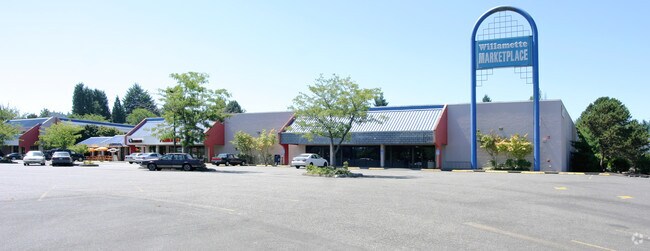

Property Detail
1990 8Th Ave
Portland-Vancouver-Hillsboro, OR-WA
SUBDIVISION WILLAMETTE TRACTS TRACTS 1-64 PT LT B BLK 37 & PT LT A BLK 41 147 SEE IMPROVEMENT ONLY ACCT 06003A1
00407660
Clackamas
Commercialbuilding
Oregon
GC
b,a
B and X Area of moderate flood hazard, usually the area between the limits of the 100-year and 500-year floods.
1 AC
2025
Lake Oswego/West Linn
2025
Portland
020700
NEARBY LISTINGS FOR SALE OR LEASE
DEMOGRAPHICS near 1990 8Th Ave
1 mile
3 mile
5 mile
2025 Total Population
8,524
48,603
129,676
2030 Population
8,489
48,462
129,529
Pop Growth 2025-2030
(0.41%)
(0.29%)
(0.11%)
Average Age
42
42
43
2025 Total Households
3,176
17,943
49,476
HH Growth 2025-2030
(0.60%)
(0.35%)
(0.17%)
Median Household Inc
$138,595
$123,807
$111,764
Avg Household Size
2.60
2.60
2.60
2025 Avg HH Vehicles
2.00
2.00
2.00
Median Home Value
$751,819
$709,706
$689,405
Median Year Built
1992
1985
1981
Nearby Places
Map Layers
Map Styles
 Street
 Aerial
Transit
 Traffic
 Biking
Places
Listings with unknown addresses are not visible on the map
- Restaurants
- Banks
- Shops
- Fitness
- Groceries
PUBLIC TRANSPORTATION
COMMUTER RAIL
Drive
Walk
Distance
9 min
4.1 mi
Tualatin (Westside Express Service - Tri-County Metropolitan Transportation District of Oregon Rail (TriMet Rail))
Drive
Walk
Distance
Tualatin (Westside Express Service - Tri-County Metropolitan Transportation District of Oregon Rail (TriMet Rail))
12 min
7.8 mi
AIRPORT
Portland International
Drive
Walk
Distance
Portland International
32 min
21.1 mi
Freight Ports
Port of Portland
Drive
Walk
Distance
Port of Portland
31 min
21.4 mi
Nearby Properties
Address
Land Use
TOTAL SIZE
Lot Size
Zoning
Address
Land Use
TOTAL SIZE
Lot Size
Zoning
58 AC
MUE
Address
Land Use
TOTAL SIZE
Lot Size
Zoning
3.11 AC
GC
Address
Land Use
TOTAL SIZE
Lot Size
Zoning
1,008 SF
10 AC
R3
Address
Land Use
TOTAL SIZE
Lot Size
Zoning
6 AC
OBC
Address
Land Use
TOTAL SIZE
Lot Size
Zoning
9.21 AC
R3
Address
Land Use
TOTAL SIZE
Lot Size
Zoning
980 SF
6.19 AC
GC
Address
Land Use
TOTAL SIZE
Lot Size
Zoning
6.16 AC
GC
Address
Land Use
TOTAL SIZE
Lot Size
Zoning
1,202 SF
3 AC
OBC
Address
Land Use
TOTAL SIZE
Lot Size
Zoning
6.14 AC
R2.1
Address
Land Use
TOTAL SIZE
Lot Size
Zoning
0.94 AC
MUD
Address
Land Use
TOTAL SIZE
Lot Size
Zoning
1,838 SF
4 AC
R3
Address
Land Use
TOTAL SIZE
Lot Size
Zoning
1,114 SF
3.11 AC
R2
Address
Land Use
TOTAL SIZE
Lot Size
Zoning
4.63 AC
GC
Address
Land Use
TOTAL SIZE
Lot Size
Zoning
2 AC
GC
Address
Land Use
TOTAL SIZE
Lot Size
Zoning
4.53 AC
R2.1
Address
Land Use
TOTAL SIZE
Lot Size
Zoning
Address
Land Use
TOTAL SIZE
Lot Size
Zoning
3.01 AC
GC
Address
Land Use
TOTAL SIZE
Lot Size
Zoning
2.33 AC
R4.5
Address
Land Use
TOTAL SIZE
Lot Size
Zoning
2,686 SF
1.17 AC
R10
Address
Land Use
TOTAL SIZE
Lot Size
Zoning
0.64 AC
GC
Address
Land Use
TOTAL SIZE
Lot Size
Zoning
0.97 AC
GC
Address
Land Use
TOTAL SIZE
Lot Size
Zoning
Address
Land Use
TOTAL SIZE
Lot Size
Zoning
4 AC
R2.1
Address
Land Use
TOTAL SIZE
Lot Size
Zoning
1,215 SF
1.98 AC
GC
Address
Land Use
TOTAL SIZE
Lot Size
Zoning
0.34 AC
GC
Address
Land Use
TOTAL SIZE
Lot Size
Zoning
3 AC
GC
Address
Land Use
TOTAL SIZE
Lot Size
Zoning
1 AC
MUD
Address
Land Use
TOTAL SIZE
Lot Size
Zoning
0.94 AC
GC
Address
Land Use
TOTAL SIZE
Lot Size
Zoning
64 AC
R10
Address
Land Use
TOTAL SIZE
Lot Size
Zoning
9,745 SF
1 AC
OBC
The World's #1 Commercial Real Estate Marketplace
Connect with us
© 2026 CoStar Group
The information above has been obtained from sources believed reliable. While we do not doubt its accuracy we have not verified it and make no guarantee, warranty or representation about it. It is your responsibility to independently confirm its accuracy and completeness. Any projections, opinions, assumptions, or estimates used are for example only and do not represent the current or future performance of the property. The value of this transaction to you depends on tax and other factors which should be evaluated by your tax, financial, and legal advisors. You and your advisors should conduct a careful, independent investigation of the property to determine to your satisfaction the suitability of the property for your needs.