Property Record
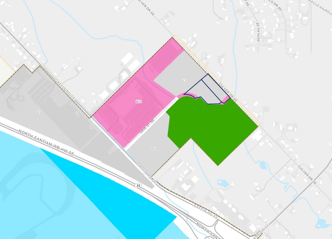
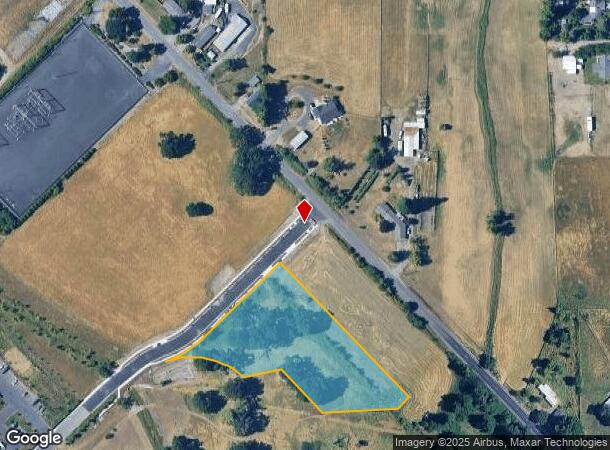
1990 Gaia St Se, Salem, OR 97317

NEARBY LISTINGS FOR SALE OR LEASE
Property Detail
1990 Gaia St Se
Portland
Pp 2022-032
Salem, OR
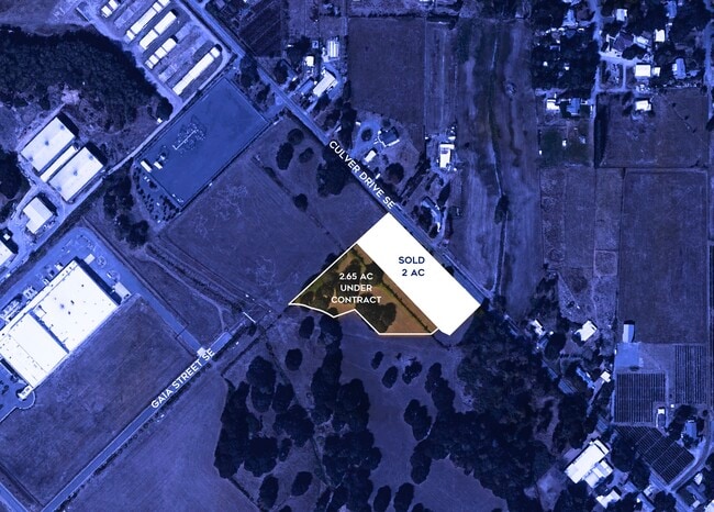
PP 2022-032 LOT 2 ACRES 2.65
605170
Marion
Officebuilding
Oregon
2024
2
2025
2.65 AC
001802
Marion County
3,780 SF
DEMOGRAPHICS near 1990 Gaia St Se
1 Mile
3 Mile
5 Mile
2024 Total Population
2,417
33,133
120,480
2029 Population
2,428
33,555
122,069
Pop Growth 2024-2029
+ 0.46%
+ 1.27%
+ 1.32%
Average Age
37
39
38
2024 Total Households
812
11,266
41,863
HH Growth 2024-2029
+ 0.49%
+ 1.35%
+ 1.37%
Median Household Inc
$82,447
$65,720
$62,130
Avg Household Size
2.90
2.80
2.70
2024 Avg HH Vehicles
2.00
2.00
2.00
Median Home Value
$360,112
$307,842
$323,625
Median Year Built
1988
1978
1977
Nearby Places
Map Layers
Map Styles
 Street
 Aerial
- Restaurants
- Banks
- Shops
- Fitness
- Groceries
PUBLIC TRANSPORTATION
COMMUTER RAIL
Salem (Amtrak Cascades - Amtrak, Coast Starlight - Amtrak)
DRIVE
WALK
Distance
Salem (Amtrak Cascades - Amtrak, Coast Starlight - Amtrak)
10 min
5.2 mi
Freight Ports
Port of Portland
DRIVE
WALK
Distance
Port of Portland
68 min
52.7 mi
SALE & LEASE HISTORY
LISTING DATE
SALE/LEASE

Nov 23, 2022
For Sale
Nearby Properties
Address
Land Use
TOTAL SIZE
Lot Size
Zoning
Address
Land Use
TOTAL SIZE
Lot Size
Zoning
1,018,020 SF
61.75 AC
EC
Address
Land Use
TOTAL SIZE
Lot Size
Zoning
257,350 SF
19.78 AC
PH
Address
Land Use
TOTAL SIZE
Lot Size
Zoning
466,506 SF
52.60 AC
EC
Address
Land Use
TOTAL SIZE
Lot Size
Zoning
412,248 SF
27.80 AC
Address
Land Use
TOTAL SIZE
Lot Size
Zoning
Address
Land Use
TOTAL SIZE
Lot Size
Zoning
341,320 SF
17.85 AC
PH
Address
Land Use
TOTAL SIZE
Lot Size
Zoning
33,560 SF
4.95 AC
CR
Address
Land Use
TOTAL SIZE
Lot Size
Zoning
152,237 SF
8.16 AC
RM2; RM1
Address
Land Use
TOTAL SIZE
Lot Size
Zoning
209,780 SF
19.85 AC
IC
Address
Land Use
TOTAL SIZE
Lot Size
Zoning
193,237 SF
9.98 AC
IG
Address
Land Use
TOTAL SIZE
Lot Size
Zoning
25.68 AC
IG
Address
Land Use
TOTAL SIZE
Lot Size
Zoning
129,850 SF
19.66 AC
IBC
Address
Land Use
TOTAL SIZE
Lot Size
Zoning
310,408 SF
203.73 AC
PH; PE
Address
Land Use
TOTAL SIZE
Lot Size
Zoning
Address
Land Use
TOTAL SIZE
Lot Size
Zoning
118,239 SF
10.69 AC
IG
Address
Land Use
TOTAL SIZE
Lot Size
Zoning
187,873 SF
10.34 AC
RM2; IC
Address
Land Use
TOTAL SIZE
Lot Size
Zoning
136,853 SF
13.32 AC
IC
Address
Land Use
TOTAL SIZE
Lot Size
Zoning
0.78 AC
PS
Address
Land Use
TOTAL SIZE
Lot Size
Zoning
167,956 SF
8.38 AC
RM2
Address
Land Use
TOTAL SIZE
Lot Size
Zoning
315,606 SF
18.68 AC
PH
Address
Land Use
TOTAL SIZE
Lot Size
Zoning
174,632 SF
4.58 AC
CO
Address
Land Use
TOTAL SIZE
Lot Size
Zoning
77,518 SF
15.90 AC
IP
Address
Land Use
TOTAL SIZE
Lot Size
Zoning
84,546 SF
9.23 AC
IC
Address
Land Use
TOTAL SIZE
Lot Size
Zoning
10.24 AC
IP
Address
Land Use
TOTAL SIZE
Lot Size
Zoning
97,720 SF
12.28 AC
PS
Address
Land Use
TOTAL SIZE
Lot Size
Zoning
97,721 SF
5 AC
RM2
Address
Land Use
TOTAL SIZE
Lot Size
Zoning
109,415 SF
7.35 AC
CR
Address
Land Use
TOTAL SIZE
Lot Size
Zoning
126,895 SF
6.98 AC
RM2
Address
Land Use
TOTAL SIZE
Lot Size
Zoning
117,691 SF
8.81 AC
CR
The World's #1 Commercial Real Estate Marketplace
Connect with us
© 2025 CoStar Group
The information above has been obtained from sources believed reliable. While we do not doubt its accuracy we have not verified it and make no guarantee, warranty or representation about it. It is your responsibility to independently confirm its accuracy and completeness. Any projections, opinions, assumptions, or estimates used are for example only and do not represent the current or future performance of the property. The value of this transaction to you depends on tax and other factors which should be evaluated by your tax, financial, and legal advisors. You and your advisors should conduct a careful, independent investigation of the property to determine to your satisfaction the suitability of the property for your needs.