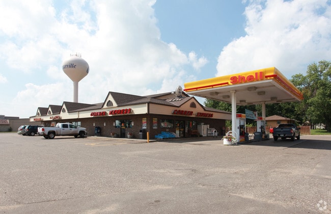
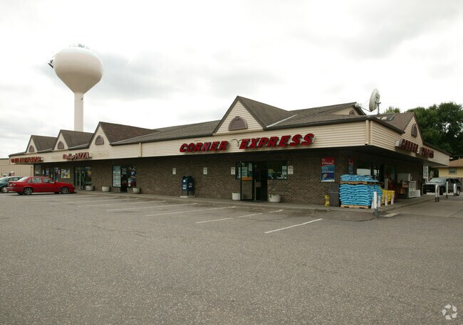
Property Record
1990 Main St, Hugo, MN 55038

Save to a Folder
{{folder.Name}}
{{folder.ListingIds.length}} Properties
{{folder.ListingIds.length}} Property
Create a New Folder
Property Detail
1990 Main St
23-31-22-14-0018
THAT PRT OF E 246.44 FT OF SE1/4 OF NE1/4 SEC 23 TWP 31 RGE22 LYG NLY OF FOL DESC LINE: COM AT NE COR THEREOF, TH S ALGE LINE THEREOF 310.89 FT TO POB, TH DEFL RT 90 DEG 58 MIN246.48 FT +OR- TO W LINE OF SD E 246.44 FT & THERE TERM; EXRD; SUBJ TO EAS
Commercialnec
Anoka
B and X Area of moderate flood hazard, usually the area between the limits of the 100-year and 500-year floods.
Minnesota
2026
1.20 AC
2026
Rosedale
050232
Minneapolis/St Paul
2,160 SF
Minneapolis-St. Paul-Bloomington, MN-WI
NEARBY LISTINGS FOR SALE OR LEASE
-
-
View all Hugo listings for sale on LoopNet.com
DEMOGRAPHICS near 1990 Main St
1 mile
3 mile
5 mile
2025 Total Population
5,117
25,110
54,109
2030 Population
5,357
26,422
55,962
Pop Growth 2025-2030
+ 4.69%
+ 5.23%
+ 3.42%
Average Age
40
40
41
2025 Total Households
1,771
9,166
19,363
HH Growth 2025-2030
+ 4.52%
+ 5.37%
+ 3.58%
Median Household Inc
$136,076
$126,674
$123,632
Avg Household Size
2.90
2.70
2.70
2025 Avg HH Vehicles
3.00
2.00
2.00
Median Home Value
$425,850
$435,718
$412,309
Median Year Built
1995
2001
1995
Nearby Places
Map Layers
Map Styles
 Street
 Aerial
Layers
 Traffic
 Biking
Places
Listings with unknown addresses are not visible on the map
- Restaurants
- Banks
- Shops
- Fitness
- Groceries
PUBLIC TRANSPORTATION
AIRPORT
Minneapolis-St Paul International/Wold-Chamberlain
Drive
Walk
Distance
Minneapolis-St Paul International/Wold-Chamberlain
42 min
26.4 mi
Nearby Properties
Address
Land Use
TOTAL SIZE
Lot Size
Zoning
Address
Land Use
TOTAL SIZE
Lot Size
Zoning
175,536 SF
7.60 AC
Address
Land Use
TOTAL SIZE
Lot Size
Zoning
402,000 SF
27.86 AC
Address
Land Use
TOTAL SIZE
Lot Size
Zoning
141,360 SF
Address
Land Use
TOTAL SIZE
Lot Size
Zoning
78,920 SF
7.50 AC
Address
Land Use
TOTAL SIZE
Lot Size
Zoning
Address
Land Use
TOTAL SIZE
Lot Size
Zoning
99,207 SF
5 AC
Address
Land Use
TOTAL SIZE
Lot Size
Zoning
100,794 SF
Address
Land Use
TOTAL SIZE
Lot Size
Zoning
Address
Land Use
TOTAL SIZE
Lot Size
Zoning
136,800 SF
Address
Land Use
TOTAL SIZE
Lot Size
Zoning
65,950 SF
9.68 AC
Address
Land Use
TOTAL SIZE
Lot Size
Zoning
163,329 SF
11.36 AC
Address
Land Use
TOTAL SIZE
Lot Size
Zoning
57,522 SF
8.63 AC
Address
Land Use
TOTAL SIZE
Lot Size
Zoning
86,423 SF
0.82 AC
Address
Land Use
TOTAL SIZE
Lot Size
Zoning
40,036 SF
18.45 AC
Address
Land Use
TOTAL SIZE
Lot Size
Zoning
137,960 SF
20 AC
Address
Land Use
TOTAL SIZE
Lot Size
Zoning
60,939 SF
Address
Land Use
TOTAL SIZE
Lot Size
Zoning
55,000 SF
Address
Land Use
TOTAL SIZE
Lot Size
Zoning
1 SF
4.40 AC
Address
Land Use
TOTAL SIZE
Lot Size
Zoning
21,056 SF
12.50 AC
Address
Land Use
TOTAL SIZE
Lot Size
Zoning
93,800 SF
13.10 AC
Address
Land Use
TOTAL SIZE
Lot Size
Zoning
83,351 SF
Address
Land Use
TOTAL SIZE
Lot Size
Zoning
63,100 SF
3.90 AC
Address
Land Use
TOTAL SIZE
Lot Size
Zoning
22,396 SF
2 AC
Address
Land Use
TOTAL SIZE
Lot Size
Zoning
19,740 SF
2.15 AC
Address
Land Use
TOTAL SIZE
Lot Size
Zoning
73,080 SF
5.88 AC
Address
Land Use
TOTAL SIZE
Lot Size
Zoning
29,373 SF
4.20 AC
Address
Land Use
TOTAL SIZE
Lot Size
Zoning
45,000 SF
3.30 AC
Address
Land Use
TOTAL SIZE
Lot Size
Zoning
74,222 SF
15.25 AC
Address
Land Use
TOTAL SIZE
Lot Size
Zoning
36,744 SF
11.99 AC
Address
Land Use
TOTAL SIZE
Lot Size
Zoning
14,152 SF
1.24 AC
The World's #1 Commercial Real Estate Marketplace
Connect with us
© 2026 CoStar Group
The information above has been obtained from sources believed reliable. While we do not doubt its accuracy we have not verified it and make no guarantee, warranty or representation about it. It is your responsibility to independently confirm its accuracy and completeness. Any projections, opinions, assumptions, or estimates used are for example only and do not represent the current or future performance of the property. The value of this transaction to you depends on tax and other factors which should be evaluated by your tax, financial, and legal advisors. You and your advisors should conduct a careful, independent investigation of the property to determine to your satisfaction the suitability of the property for your needs.