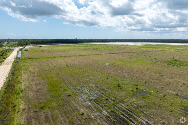
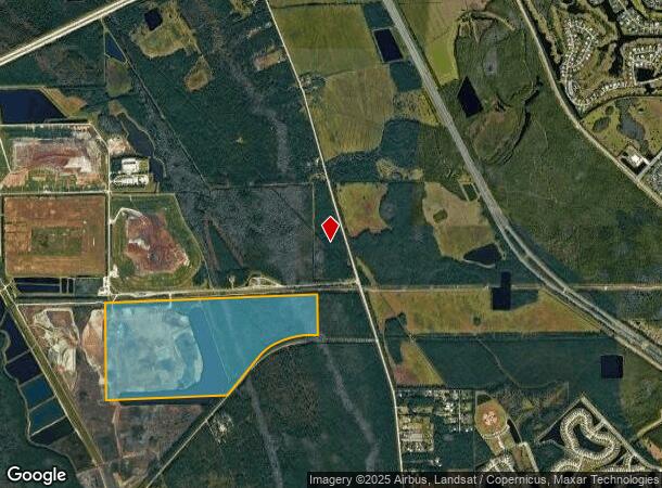
Property Record
1990 Tomoka Farms Rd, Port Orange, FL 32128

NEARBY LISTINGS FOR SALE OR LEASE
-
-
View all Port Orange listings for sale on LoopNet.com
Property Detail
1990 Tomoka Farms Rd
Deltona-Daytona Beach-Ormond Beach, FL
Easement
6210-00-00-0020
10-16-32 S 1/2 EXC S OF N/L OF OR 2537 PG 1320 EASEMENT & EXC 50% SUBSURFACE RIGHTS PER OR 3293 PG 0365
Vacantlandnec
Volusia
A
Florida
12127C0502J
293.14 AC
0
SE Volusia County
2025
Deltona/Daytona Beach
083207
DEMOGRAPHICS near 1990 Tomoka Farms Rd
1 Mile
3 Mile
5 Mile
2024 Total Population
0
9,377
54,235
2029 Population
0
10,361
59,851
Pop Growth 2024-2029
0.00%
+ 10.49%
+ 10.35%
Average Age
0
44
45
2024 Total Households
0
4,093
23,738
HH Growth 2024-2029
0.00%
+ 10.70%
+ 10.93%
Median Household Inc
$0
$58,384
$57,006
Avg Household Size
.00
2.20
2.10
2024 Avg HH Vehicles
.00
2.00
2.00
Median Home Value
$0
$262,723
$240,566
Median Year Built
0
2003
1989
Nearby Places
Map Layers
Map Styles
 Street
 Aerial
- Restaurants
- Banks
- Shops
- Fitness
- Groceries
PUBLIC TRANSPORTATION
AIRPORT
Daytona Beach International
DRIVE
WALK
Distance
Daytona Beach International
9 min
4.5 mi
Orlando Sanford International
DRIVE
WALK
Distance
Orlando Sanford International
49 min
31.8 mi
Freight Ports
Port Canaveral
DRIVE
WALK
Distance
Port Canaveral
83 min
68.1 mi
Nearby Properties
Address
Land Use
TOTAL SIZE
Lot Size
Zoning
Address
Land Use
TOTAL SIZE
Lot Size
Zoning
481,883 SF
0.10 AC
Address
Land Use
TOTAL SIZE
Lot Size
Zoning
33,958 SF
190.21 AC
A2
Address
Land Use
TOTAL SIZE
Lot Size
Zoning
442,125 SF
0.98 AC
A21
Address
Land Use
TOTAL SIZE
Lot Size
Zoning
490,775 SF
34.26 AC
01MH1
Address
Land Use
TOTAL SIZE
Lot Size
Zoning
396,385 SF
10 AC
01A2
Address
Land Use
TOTAL SIZE
Lot Size
Zoning
354,546 SF
24.71 AC
Address
Land Use
TOTAL SIZE
Lot Size
Zoning
462,136 SF
31.84 AC
01A2
Address
Land Use
TOTAL SIZE
Lot Size
Zoning
416,320 SF
0.13 AC
Address
Land Use
TOTAL SIZE
Lot Size
Zoning
408,078 SF
50.07 AC
Address
Land Use
TOTAL SIZE
Lot Size
Zoning
10,360 SF
1.56 AC
Address
Land Use
TOTAL SIZE
Lot Size
Zoning
412,064 SF
60 AC
Address
Land Use
TOTAL SIZE
Lot Size
Zoning
201,947 SF
0.23 AC
Address
Land Use
TOTAL SIZE
Lot Size
Zoning
175,132 SF
5 AC
Address
Land Use
TOTAL SIZE
Lot Size
Zoning
8,355 SF
1 AC
MH1
Address
Land Use
TOTAL SIZE
Lot Size
Zoning
141,361 SF
19.02 AC
Address
Land Use
TOTAL SIZE
Lot Size
Zoning
229,029 SF
0.43 AC
16PUD
Address
Land Use
TOTAL SIZE
Lot Size
Zoning
127,664 SF
15.07 AC
Address
Land Use
TOTAL SIZE
Lot Size
Zoning
62,574 SF
6.90 AC
MH1
Address
Land Use
TOTAL SIZE
Lot Size
Zoning
136.46 AC
B4
Address
Land Use
TOTAL SIZE
Lot Size
Zoning
105,676 SF
11.77 AC
Address
Land Use
TOTAL SIZE
Lot Size
Zoning
41,907 SF
3.83 AC
Address
Land Use
TOTAL SIZE
Lot Size
Zoning
106,441 SF
9.94 AC
IPUD
Address
Land Use
TOTAL SIZE
Lot Size
Zoning
220,091 SF
1.81 AC
Address
Land Use
TOTAL SIZE
Lot Size
Zoning
65,290 SF
38.49 AC
A22
Address
Land Use
TOTAL SIZE
Lot Size
Zoning
52,162 SF
144.25 AC
01A2
Address
Land Use
TOTAL SIZE
Lot Size
Zoning
49,391 SF
11.25 AC
BPUD
Address
Land Use
TOTAL SIZE
Lot Size
Zoning
90,949 SF
17.94 AC
IPUD
Address
Land Use
TOTAL SIZE
Lot Size
Zoning
85,048 SF
2.26 AC
Address
Land Use
TOTAL SIZE
Lot Size
Zoning
37,456 SF
4.51 AC
Address
Land Use
TOTAL SIZE
Lot Size
Zoning
45,150 SF
4.39 AC
The World's #1 Commercial Real Estate Marketplace
Connect with us
© 2025 CoStar Group
The information above has been obtained from sources believed reliable. While we do not doubt its accuracy we have not verified it and make no guarantee, warranty or representation about it. It is your responsibility to independently confirm its accuracy and completeness. Any projections, opinions, assumptions, or estimates used are for example only and do not represent the current or future performance of the property. The value of this transaction to you depends on tax and other factors which should be evaluated by your tax, financial, and legal advisors. You and your advisors should conduct a careful, independent investigation of the property to determine to your satisfaction the suitability of the property for your needs.