Property Record
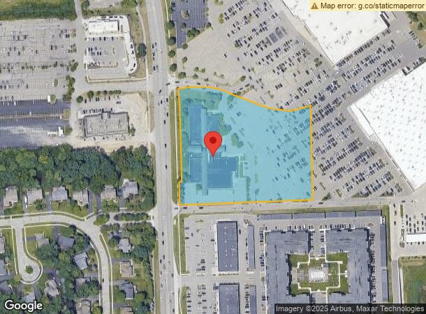
19900 Haggerty Rd, Livonia, MI 48152

Current Lease Availabilities
NEARBY LISTINGS FOR SALE OR LEASE
-
-
View all Livonia listings for lease on LoopNet.com
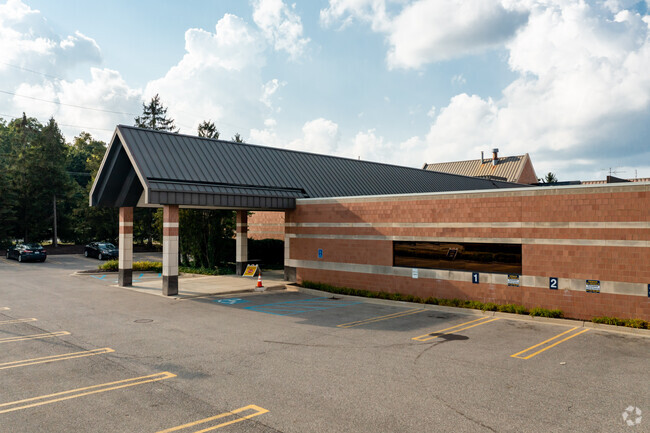
Property Detail
19900 Haggerty Rd
46-022-99-0004-002
PARCEL OF LAND BEING PT OF NW 1/4 SEC 6 T1S R9E WCR COMM AT THE W 1/4 COR SEC 6 TH N 01D 46M 19S W 30.0 FT ALONG W LINE N 87D 31M 16S E 60.0 FT TO POB TH N 01D 46M 19S W 101.10 FT TH N 89D 19M 50S E 5.0 FT TH N 01D 46M 19S W 387.01 FT TH N 88D 13M 39
Medicalbuilding
Wayne
X
Michigan
26163C0045E
0004
2025
5 AC
2025
Southern I-275 Corridor
556500
Detroit
45,078 SF
Detroit-Warren-Dearborn, MI
DEMOGRAPHICS near 19900 Haggerty Rd
1 Mile
3 Mile
5 Mile
2024 Total Population
2,499
73,638
171,860
2029 Population
2,435
71,457
166,958
Pop Growth 2024-2029
(2.56%)
(2.96%)
(2.85%)
Average Age
47
44
43
2024 Total Households
967
31,538
72,279
HH Growth 2024-2029
(2.38%)
(2.92%)
(2.83%)
Median Household Inc
$121,956
$102,395
$103,518
Avg Household Size
2.40
2.30
2.30
2024 Avg HH Vehicles
2.00
2.00
2.00
Median Home Value
$413,654
$329,145
$318,884
Median Year Built
1986
1979
1977
Nearby Places
Map Layers
Map Styles
 Street
 Aerial
- Restaurants
- Banks
- Shops
- Fitness
- Groceries
PUBLIC TRANSPORTATION
AIRPORT
Detroit Metro Wayne County
DRIVE
WALK
Distance
Detroit Metro Wayne County
32 min
23.0 mi
Windsor International
DRIVE
WALK
Distance
Windsor International
55 min
36.0 mi
Nearby Properties
Address
Land Use
TOTAL SIZE
Lot Size
Zoning
Address
Land Use
TOTAL SIZE
Lot Size
Zoning
57.28 AC
RM-1
Address
Land Use
TOTAL SIZE
Lot Size
Zoning
234,403 SF
74.21 AC
OS
Address
Land Use
TOTAL SIZE
Lot Size
Zoning
250,699 SF
16.89 AC
SH
Address
Land Use
TOTAL SIZE
Lot Size
Zoning
182,121 SF
10.85 AC
HPUD
Address
Land Use
TOTAL SIZE
Lot Size
Zoning
406,560 SF
46.04 AC
AI
Address
Land Use
TOTAL SIZE
Lot Size
Zoning
42.06 AC
RM-1
Address
Land Use
TOTAL SIZE
Lot Size
Zoning
38 AC
RM-1
Address
Land Use
TOTAL SIZE
Lot Size
Zoning
325,281 SF
36.25 AC
AI
Address
Land Use
TOTAL SIZE
Lot Size
Zoning
102,878 SF
10.48 AC
CJ
Address
Land Use
TOTAL SIZE
Lot Size
Zoning
327,206 SF
29.93 AC
AI
Address
Land Use
TOTAL SIZE
Lot Size
Zoning
192,478 SF
IND
Address
Land Use
TOTAL SIZE
Lot Size
Zoning
289,722 SF
7.34 AC
C-2
Address
Land Use
TOTAL SIZE
Lot Size
Zoning
228,748 SF
25.06 AC
AI
Address
Land Use
TOTAL SIZE
Lot Size
Zoning
30.32 AC
RM-1
Address
Land Use
TOTAL SIZE
Lot Size
Zoning
5,339 SF
20.10 AC
R-3
Address
Land Use
TOTAL SIZE
Lot Size
Zoning
214,242 SF
22.40 AC
AI
Address
Land Use
TOTAL SIZE
Lot Size
Zoning
264,994 SF
19.75 AC
AI
Address
Land Use
TOTAL SIZE
Lot Size
Zoning
730,656 SF
13.73 AC
C-4
Address
Land Use
TOTAL SIZE
Lot Size
Zoning
206,496 SF
12.72 AC
PO
Address
Land Use
TOTAL SIZE
Lot Size
Zoning
218,690 SF
10.02 AC
AI
Address
Land Use
TOTAL SIZE
Lot Size
Zoning
80,574 SF
19.95 AC
7MIPUD
Address
Land Use
TOTAL SIZE
Lot Size
Zoning
9,706 SF
40.41 AC
RM-1
Address
Land Use
TOTAL SIZE
Lot Size
Zoning
129,448 SF
9.37 AC
OSC
Address
Land Use
TOTAL SIZE
Lot Size
Zoning
Address
Land Use
TOTAL SIZE
Lot Size
Zoning
110,220 SF
0.78 AC
CBD
Address
Land Use
TOTAL SIZE
Lot Size
Zoning
46.60 AC
R-3
Address
Land Use
TOTAL SIZE
Lot Size
Zoning
66,109 SF
35.02 AC
PO
Address
Land Use
TOTAL SIZE
Lot Size
Zoning
976 SF
26.85 AC
RM-1
Address
Land Use
TOTAL SIZE
Lot Size
Zoning
Address
Land Use
TOTAL SIZE
Lot Size
Zoning
152,414 SF
13.91 AC
RM-1
The World's #1 Commercial Real Estate Marketplace
Connect with us
© 2026 CoStar Group
The information above has been obtained from sources believed reliable. While we do not doubt its accuracy we have not verified it and make no guarantee, warranty or representation about it. It is your responsibility to independently confirm its accuracy and completeness. Any projections, opinions, assumptions, or estimates used are for example only and do not represent the current or future performance of the property. The value of this transaction to you depends on tax and other factors which should be evaluated by your tax, financial, and legal advisors. You and your advisors should conduct a careful, independent investigation of the property to determine to your satisfaction the suitability of the property for your needs.