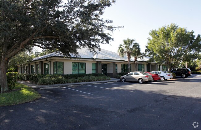
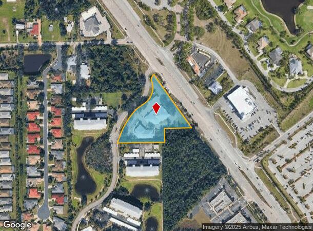
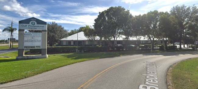
Property Record
19910 S Tamiami Trl, Estero, FL 33928
NEARBY LISTINGS FOR SALE OR LEASE
Property Detail
19910 S Tamiami Trl
20-46-25-E3-U1810.2594
S. 41 Corridor
Officebuilding
PAR IN MULTI SECS 20 + 21 FR SE COR SEC 20 DESC OR 2593 PG 3068 + OR 582 PG 2781
X
Lee
12071C0579G
Florida
2024
2.46 AC
2025
Estero
050104
Southwest Florida
20,071 SF
Cape Coral-Fort Myers, FL
DEMOGRAPHICS near 19910 S Tamiami Trl
1 Mile
3 Mile
5 Mile
2024 Total Population
7,975
54,148
82,883
2029 Population
9,582
64,372
98,965
Pop Growth 2024-2029
+ 20.15%
+ 18.88%
+ 19.40%
Average Age
55
45
50
2024 Total Households
4,003
22,919
36,915
HH Growth 2024-2029
+ 20.16%
+ 18.82%
+ 19.33%
Median Household Inc
$63,942
$79,733
$84,581
Avg Household Size
1.90
2.30
2.20
2024 Avg HH Vehicles
2.00
2.00
2.00
Median Home Value
$221,268
$295,951
$347,176
Median Year Built
1995
1998
2000
Nearby Places
Map Layers
Map Styles
 Street
 Aerial
- Restaurants
- Banks
- Shops
- Fitness
- Groceries
PUBLIC TRANSPORTATION
AIRPORT
Southwest Florida International
DRIVE
WALK
Distance
Southwest Florida International
24 min
13.3 mi
Punta Gorda
DRIVE
WALK
Distance
Punta Gorda
53 min
43.3 mi
SALE & LEASE HISTORY
LISTING DATE
SALE/LEASE

Sep 30, 2019
For Lease
Sep 24, 2016
For Lease
Nearby Properties
Address
Land Use
TOTAL SIZE
Lot Size
Zoning
Address
Land Use
TOTAL SIZE
Lot Size
Zoning
4,413,774 SF
760.09 AC
AG-2
Address
Land Use
TOTAL SIZE
Lot Size
Zoning
100,557 SF
17.66 AC
CPD
Address
Land Use
TOTAL SIZE
Lot Size
Zoning
20.19 AC
MPD
Address
Land Use
TOTAL SIZE
Lot Size
Zoning
395,259 SF
16.56 AC
MPD
Address
Land Use
TOTAL SIZE
Lot Size
Zoning
385,229 SF
16.69 AC
RPD
Address
Land Use
TOTAL SIZE
Lot Size
Zoning
462,334 SF
32.45 AC
MPD
Address
Land Use
TOTAL SIZE
Lot Size
Zoning
369,577 SF
16.39 AC
RPD
Address
Land Use
TOTAL SIZE
Lot Size
Zoning
482,782 SF
27.98 AC
CPD
Address
Land Use
TOTAL SIZE
Lot Size
Zoning
294,689 SF
17.95 AC
MPD
Address
Land Use
TOTAL SIZE
Lot Size
Zoning
345,170 SF
21.32 AC
RPD
Address
Land Use
TOTAL SIZE
Lot Size
Zoning
291,157 SF
23.38 AC
RPD
Address
Land Use
TOTAL SIZE
Lot Size
Zoning
540,648 SF
19.75 AC
MPD
Address
Land Use
TOTAL SIZE
Lot Size
Zoning
245,356 SF
12.54 AC
MPD
Address
Land Use
TOTAL SIZE
Lot Size
Zoning
274,691 SF
6.62 AC
MPD
Address
Land Use
TOTAL SIZE
Lot Size
Zoning
348,757 SF
69.01 AC
CF-2
Address
Land Use
TOTAL SIZE
Lot Size
Zoning
Address
Land Use
TOTAL SIZE
Lot Size
Zoning
69.37 AC
RPD
Address
Land Use
TOTAL SIZE
Lot Size
Zoning
14.42 AC
RPD
Address
Land Use
TOTAL SIZE
Lot Size
Zoning
5.39 AC
RPD
Address
Land Use
TOTAL SIZE
Lot Size
Zoning
236,456 SF
27.05 AC
MPD
Address
Land Use
TOTAL SIZE
Lot Size
Zoning
239.40 AC
Address
Land Use
TOTAL SIZE
Lot Size
Zoning
166,672 SF
8.58 AC
CPD
Address
Land Use
TOTAL SIZE
Lot Size
Zoning
79,833 SF
9.16 AC
Address
Land Use
TOTAL SIZE
Lot Size
Zoning
139,174 SF
4.73 AC
CPD
Address
Land Use
TOTAL SIZE
Lot Size
Zoning
247,870 SF
15.95 AC
MPD
Address
Land Use
TOTAL SIZE
Lot Size
Zoning
151,366 SF
15.47 AC
CPD
Address
Land Use
TOTAL SIZE
Lot Size
Zoning
123,815 SF
23.62 AC
CPD
Address
Land Use
TOTAL SIZE
Lot Size
Zoning
120,254 SF
5.32 AC
CPD
Address
Land Use
TOTAL SIZE
Lot Size
Zoning
21.13 AC
H
Address
Land Use
TOTAL SIZE
Lot Size
Zoning
122,339 SF
19.39 AC
RPD
The World's #1 Commercial Real Estate Marketplace
Connect with us
© 2025 CoStar Group
The information above has been obtained from sources believed reliable. While we do not doubt its accuracy we have not verified it and make no guarantee, warranty or representation about it. It is your responsibility to independently confirm its accuracy and completeness. Any projections, opinions, assumptions, or estimates used are for example only and do not represent the current or future performance of the property. The value of this transaction to you depends on tax and other factors which should be evaluated by your tax, financial, and legal advisors. You and your advisors should conduct a careful, independent investigation of the property to determine to your satisfaction the suitability of the property for your needs.